Norway Point Bottomlands
No. 151
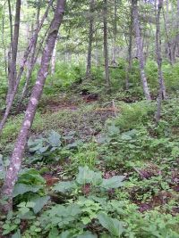
Photo by B. Delaney
Norway Point Bottomlands lies along a bend in the St. Croix River and encompasses five major lowland plant communities including a southern wet-mesic forest at its northern range limit in Wisconsin. Also present are a northern wet-mesic forest, shrub carr, northern sedge meadow, and a 0.3-mile reach of Iron Creek. Closest to the river is a bottomland hardwood forest with silver maple, American elm, white ash, and black ash. Between the floodplain and uplands are swamp hardwoods dominated by black ash with yellow birch and elm.
Along the base of the river terrace escarpments are similar hardwoods and white cedar with numerous springs and seeps that feed into Iron Creek. Willow, alder, dogwood, and Spirea dominate the surrounding shrub thickets. The adjacent sedge meadow was historically used for mowing before state ownership. Iron Creek is a minnow stream with turbid, acid, and infertile waters.
The wetlands provide nesting habitat for waterfowl and the area is home to high beaver and deer populations. Common breeding birds include the eastern bluebird, the eastern wood pewee, the veery, red-eyed vireo, the ovenbird, the mourning warbler, the black and white warbler, and the pileated woodpecker. Norway Point is owned by the DNR and National Park Service. It was designated a State Natural Area in 1979 and later expanded to include the St. Croix River.
Very few State Natural Areas have public facilities, but nearly all are open for a variety of recreational activities as indicated below. Generally, there are no picnic areas, restrooms, or other developments. Parking lots or designated parking areas are noted on individual SNA pages and maps. If a developed trail is present, it will normally be noted on the SNA map and/or under the Maps tab. A compass and topographic map or a GPS unit are useful tools for exploring larger, isolated SNAs.
The good majority of SNAs are isolated and have few or no facilities. Some SNAs have vehicle access lanes or parking lots, but their accessibility may vary depending on weather conditions. Parking lots and lanes are not plowed during winter. Hiking trails may be nonexistent or consist of undeveloped footpaths. A GPS unit or compass and a detailed topographic map are useful tools for exploring larger SNAs.
Hunting and trapping
Allowable activities: DNR-owned land
The activities listed below are generally allowed on all DNR-owned SNA lands. Exceptions to this list of public uses, such as SNAs closed to hunting, are noted above and posted with signs on the property site.
- Hiking
- Fishing
- Cross country skiing
- Hunting
- Trapping
- Scientific research (permit required [PDF])
- Outdoor education
- Wild edibles (What is this?)
- Pets (Rules)
- Wildlife viewing
Prohibited activities: all SNAs
- Camping and campfires
- Collecting of animals (other than legally harvested species), non-edible fungi, rocks, minerals, fossils, archaeological artifacts, soil, downed wood, or any other natural material, alive or dead.
- Collecting for scientific research requires a permit issued by the DNR
- Collecting of plants including seeds, roots or other non-edible parts of herbaceous plants such as wildflowers or grasses
- Geocaching
- Horseback riding
- Rock climbing
- Vehicles, including bicycles, ATVs, aircraft, and snowmobiles except on trails and roadways designated for their use.
For rules governing state-owned SNAs and other state lands, please consult Chapter NR 45 Wis. Admin. Code [exit DNR].
Location
Within Governor Knowles State Forest and the St. Croix National Scenic Riverway, Burnett County. T40N-R17W, Section 6. T40N-R18W, Sections 12-15, 19-24, 26-30. 4,022 acres.
Driving directions
From the intersection of Highways D and F at the north end of Grantsburg, go north on County Highway F for 9 miles, then north on Norway Point Road for 2 miles to a boat landing on the St. Croix River. Walk northeast into the area. An interpretive trail loops through the swamp.
The DNR's state natural areas program is comprised of lands owned by the state, private conservation organizations, municipalities, other governmental agencies, educational institutions and private individuals. While the majority of SNAs are open to the public, access may vary according to individual ownership policies. Public use restrictions may apply due to public safety, or to protect endangered or threatened species or unique natural features. Lands may be temporarily closed due to specific management activities.
Users are encouraged to contact the landowner for more specific details. The data shown on these maps have been obtained from various sources, and are of varying age, reliability, and resolution. The data may contain errors or omissions and should not be interpreted as a legal representation of legal ownership boundaries. To create your custom map where you can zoom to a specific location, please use the DNR's Mapping Application.
Norway Point Bottomlands is owned by: National Park Service and the Wisconsin DNR
Management objectives and prescriptions
- Read the Governor Knowles Master Plan [PDF] for details on the management of the DNR-owned portion of the natural area.