Northeast Lake
No. 472
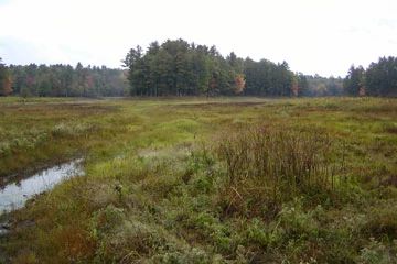
Photo by U.S. Forest Service
The primary features of this site are the two largely undeveloped lakes and a mosaic of upland northern dry-mesic forest and open bog. Both Northeast Lake and Sugar Bush Lake are soft-water seepage lakes surrounded by peatlands that support numerous rare plants and animals. Extensive emergent aquatics are found in Northeast Lake, which attracts large numbers of ducks and waterfowl. Near the northeast shore of Sugar Bush Lake (Mud Lake) is a diverse, extensive sphagnum-cranberry lawn with numerous sedges, leatherleaf, bog rosemary, grass pink, tawny cotton-grass, creeping snowberry, bog buckbean, pitcher plant, and horned bladderwort. To the south is an alder/tamarack/black spruce swamp with Labrador-tea, three-leaf Solomon's-seal, bunchberry, small green-fringed orchid, and bog birch.
Of note are the rare species present including the state-endangered lesser wintergreen, swamp pink, brown beak rush, and bog fritillary butterfly. Other Lepidoptera includes bog copper, brown elfin, eastern pine elfin, arctic jutta, and hobomok skipper. The uplands are comprised of dry red oak and white pine forest with canopy trees 28 to 30 inches in diameter. Red pine is also present. Numerous white pine saplings occur in scattered areas. The ground flora includes bracken fern, wild sarsaparilla, Canada mayflower, American starflower, rice grass, blueberries, and Pennsylvania sedge. Birds using the area include bald eagle, common raven, hermit thrush, cedar waxwing, red-eyed vireo, white-breasted nuthatch, red-breasted nuthatch, and eastern wood pewee. Northeast Lake is owned by the US Forest Service and was designated a State Natural Area in 2007.
Very few State Natural Areas have public facilities, but nearly all are open for a variety of recreational activities as indicated below. Generally, there are no picnic areas, restrooms, or other developments. Parking lots or designated parking areas are noted on individual SNA pages and maps. If a developed trail is present, it will normally be noted on the SNA map and/or under the Maps tab. A compass and topographic map or a GPS unit are useful tools for exploring larger, isolated SNAs.
The good majority of SNAs are isolated and have few or no facilities. Some SNAs have vehicle access lanes or parking lots, but their accessibility may vary depending on weather conditions. Parking lots and lanes are not plowed during winter. Hiking trails may be nonexistent or consist of undeveloped footpaths. A GPS unit or compass and a detailed topographic map are useful tools for exploring larger SNAs.
Non-DNR lands
Entrance fees: For non-DNR-owned SNAs, we are unaware of any vehicle or admission fees. However, please contact the landowner for more information.
Hunting and trapping
Other activities
Other allowable activities such as - but not limited to camping, geocaching and bicycling are determined by the landowner. Please contact them directly or visit their websites for details.
Location
Within the Chequamegon-Nicolet National Forest. Bayfield County. T44N-R7W, Sections 23, 25, 26, 27, 35, 36. 833 acres.
Driving directions
The site is located approximately 5 miles northeast of Cable, WI. From Cable, go east on County M for 2.5 miles, then north on FR 214 for 4 miles, then east on FR 373 to the site.
The DNR's state natural areas program is comprised of lands owned by the state, private conservation organizations, municipalities, other governmental agencies, educational institutions and private individuals. While the majority of SNAs are open to the public, access may vary according to individual ownership policies. Public use restrictions may apply due to public safety, or to protect endangered or threatened species or unique natural features. Lands may be temporarily closed due to specific management activities.
Users are encouraged to contact the landowner for more specific details. The data shown on these maps have been obtained from various sources, and are of varying age, reliability, and resolution. The data may contain errors or omissions and should not be interpreted as a legal representation of legal ownership boundaries. To create your custom map where you can zoom to a specific location, please use the DNR's Mapping Application.
Northeast Lake is owned by: US Forest Service