Northeast Coulee Oak Woodland
No. 597
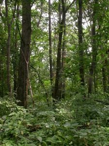
Photo by Wisconsin DNR
Situated at the northern edge of the Coulee Experimental Forest, this site features a large block of mature southern dry-mesic forest that is developing old-growth characteristics and has excellent structure and composition. The forest occurs on the north-facing slope of a sandstone ridge and is dominated by large red oak up to 45 inches in diameter with white oak, basswood, and red maple. Canopy associates include shagbark hickory, white ash, American elm, and black cherry. The most intact areas are of excellent quality, showing little to no evidence of past disturbance. Characteristic herbaceous species include wild sarsaparilla, maidenhair fern, wild geranium, large-flowered bellwort, and enchanter's nightshade.
More mesic patches support two-leaved miterwort, blue cohosh, and Goldie's fern. At the southern end of the site is a small dry prairie located on a very steep south-facing slope. Numerous characteristic species include little bluestem, side-oats grama, lead plant, silky aster, and gray goldenrod. Also present are moist outcroppings of limy sandstone near the crest of a steep north-facing slope. This area supports species such as bulblet fern, fragile fern, wild columbine, hairy goldenrod, and harebell. Also present is the uncommon jeweled shooting star, a plant found primarily within the Driftless Area. Breeding birds include the yellow-billed cuckoo, the eastern wood pewee, veery, wood thrush, ovenbird, mourning warbler, scarlet tanager, and rose-breasted grosbeak. Northeast Coulee Oak Woodland is owned by the DNR and was designated a State Natural Area in 2009.
Very few State Natural Areas have public facilities, but nearly all are open for a variety of recreational activities as indicated below. Generally, there are no picnic areas, restrooms, or other developments. Parking lots or designated parking areas are noted on individual SNA pages and maps. If a developed trail is present, it will normally be noted on the SNA map and/or under the Maps tab. A compass and topographic map or a GPS unit are useful tools for exploring larger, isolated SNAs.
The good majority of SNAs are isolated and have few or no facilities. Some SNAs have vehicle access lanes or parking lots, but their accessibility may vary depending on weather conditions. Parking lots and lanes are not plowed during winter. Hiking trails may be nonexistent or consist of undeveloped footpaths. A GPS unit or compass and a detailed topographic map are useful tools for exploring larger SNAs.
Entrance fees: Except for Parfrey's Glen, the Cambrian Outlook in the Dells of the Wisconsin River, SNAs within State Parks and some within State Forests, all other DNR-owned SNAs do not have any admission fees. For more information, see Wis. Admin. Code NR 45 [exit DNR]. For non-DNR-owned SNAs, we are unaware of any vehicle or admission fees. However, please contact the landowner for more information.
Allowable activities: DNR-owned land
The activities listed below are generally allowed on all DNR-owned SNA lands. Exceptions to this list of public uses, such as SNAs closed to hunting, are noted above and posted with signs on the property site.
- Hiking
- Fishing
- Cross country skiing
- Hunting
- Trapping
- Scientific research (permit required [PDF])
- Outdoor education
- Wild edibles (What is this?)
- Pets (Rules)
- Wildlife viewing
Prohibited activities: all SNAs
Although a handful of sites allow activities like primitive camping (e.g. Lower Chippewa River on sand bars) or horseback riding (e.g. S. Kettle Moraine), the activities listed below are generally prohibited on DNR-owned SNAs.
- Camping and campfires
- Collecting of animals (other than legally harvested species), non-edible fungi, rocks, minerals, fossils, archaeological artifacts, soil, downed wood, or any other natural material, alive or dead.
- Collecting for scientific research requires a permit issued by the DNR
- Collecting of plants including seeds, roots or other non-edible parts of herbaceous plants such as wildflowers or grasses
- Drones: Flying-related activities, including the use of drones, hang-gliders and model airplanes, are prohibited. Permission may be issued by the SNA Program for the use of drones for educational or research purposes
- Geocaching
- Horseback riding
- Rock climbing
- Vehicles, including bicycles, ATVs, aircraft, and snowmobiles except on trails and roadways designated for their use.
For rules governing state-owned SNAs and other state lands, please consult Chapter NR 45 Wis. Admin. Code [exit DNR].
Location
Within the Coulee Experimental Forest, La Crosse County. T16N-R5W, Section 18. T16N-R6W, Section 13. 287 acres.
Driving directions
From the I-90 and State Highway 62 interchange in Bangor, go south on 62 for 1.1 miles, then west on Russlan Coulee Road for 1.7 miles and park. Walk another 0.5 miles along the primitive state road (no vehicles allowed), then head north to the site.
The DNR's state natural areas program is comprised of lands owned by the state, private conservation organizations, municipalities, other governmental agencies, educational institutions and private individuals. While the majority of SNAs are open to the public, access may vary according to individual ownership policies. Public use restrictions may apply due to public safety, or to protect endangered or threatened species or unique natural features. Lands may be temporarily closed due to specific management activities.
Users are encouraged to contact the landowner for more specific details. The data shown on these maps have been obtained from various sources, and are of varying age, reliability, and resolution. The data may contain errors or omissions and should not be interpreted as a legal representation of legal ownership boundaries. To create your custom map where you can zoom to a specific location, please use the DNR's Mapping Application.
Northeast Coulee Oak Woodland is owned by: Wisconsin DNR