North Otter Creek
No. 448
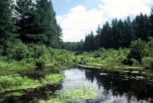
Photo by U.S. Forest Service
North Otter Creek features a fairly extensive hemlock hardwood forest dominated by large sugar maple and eastern hemlock with basswood, and yellow birch. Situated in hummocky topography, these stands form the bulk of the upland acreage of the complex. Lower areas along stream segments are often forested with hemlock and northern white cedar. Lowland community types include an area of old-growth white cedar in the northeast corner of the complex. Tiny spring holes feed a small creek that flows through this stand.
Other lowland community types include sedge meadow, shrub-carr, alder thicket, and black spruce-tamarack swamp. The riparian areas along the stream corridor are very diverse. One of the most interesting areas contains springs that originate in the uplands and that feed small spring ponds which in turn feed a small creek that then flows north into North Otter Creek. The opening along the stream corridor originated from beaver activity and now is an interesting mix of sedge meadow, alder thicket, and shrub carr. This diverse complex supports numerous rare plants and animals. North Otter Creek is owned by the US Forest Service and was designated a State Natural Area in 2007.
Very few State Natural Areas have public facilities, but nearly all are open for a variety of recreational activities as indicated below. Generally, there are no picnic areas, restrooms, or other developments. Parking lots or designated parking areas are noted on individual SNA pages and maps. If a developed trail is present, it will normally be noted on the SNA map and/or under the Maps tab. A compass and topographic map or a GPS unit are useful tools for exploring larger, isolated SNAs.
The good majority of SNAs are isolated and have few or no facilities. Some SNAs have vehicle access lanes or parking lots, but their accessibility may vary depending on weather conditions. Parking lots and lanes are not plowed during winter. Hiking trails may be nonexistent or consist of undeveloped footpaths. A GPS unit or compass and a detailed topographic map are useful tools for exploring larger SNAs.
Non-DNR lands
Entrance fees: For non-DNR-owned SNAs, we are unaware of any vehicle or admission fees. However, please contact the landowner for more information.
Hunting and trapping
Other activities
Other allowable activities such as - but not limited to camping, geocaching and bicycling are determined by the landowner. Please contact them directly or visit their websites for details.
Location
Located within the Chequamegon-Nicolet National Forest. Forest County. T36N-R14E, Sections 7, 18. 724 acres.
Driving directions
The site is located between Crandon and Laona approximately 2 miles north of Highway 8. From the intersection of Highway 8 and US Highway 55, go east on Hwy 8 for 5 miles, then north on Otter Creek Road for 0.65 miles, then northeast on Margies Road for 2.4 miles, then west on FR 2379 for 0.6 miles. The site lies northeast and southwest of the road.
The DNR's state natural areas program is comprised of lands owned by the state, private conservation organizations, municipalities, other governmental agencies, educational institutions and private individuals. While the majority of SNAs are open to the public, access may vary according to individual ownership policies. Public use restrictions may apply due to public safety, or to protect endangered or threatened species or unique natural features. Lands may be temporarily closed due to specific management activities.
Users are encouraged to contact the landowner for more specific details. The data shown on these maps have been obtained from various sources, and are of varying age, reliability, and resolution. The data may contain errors or omissions and should not be interpreted as a legal representation of legal ownership boundaries. To create your custom map where you can zoom to a specific location, please use the DNR's Mapping Application.
North Otter Creek is owned by: US Forest Service