North Fork Eau Claire River
No. 525
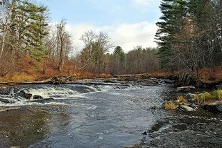
Photo by Aaron Carlson
North Fork Eau Claire River features a 3-mile stretch of the north fork from just north of Hamilton Falls to just south of the confluence with Beeman Creek. This warm-water drainage stream flows from Clark County southwest into the main branch of the Eau Claire River. Most of the site focuses on the river and adjacent cliff communities, although the southern portion extends to cover oxbows, islands, and adjacent meadows and savannas. This relatively wild reach contains several rare aquatic invertebrates.
The cliffs and steep-sided terraces harbor many rarer to uncommon plants and animals. These types of natural communities have received little recognition for their ecological reference attributes in the past. Cooperative recognition between Eau Claire County and the State Natural Area Program will provide long-term protection of this unique resource. North Fork Eau Claire River is owned by Eau Claire County and was designated a State Natural Area in 2007.
Very few State Natural Areas have public facilities, but nearly all are open for a variety of recreational activities as indicated below. Generally, there are no picnic areas, restrooms, or other developments. Parking lots or designated parking areas are noted on individual SNA pages and maps. If a developed trail is present, it will normally be noted on the SNA map and/or under the Maps tab. A compass and topographic map or a GPS unit are useful tools for exploring larger, isolated SNAs.
The good majority of SNAs are isolated and have few or no facilities. Some SNAs have vehicle access lanes or parking lots, but their accessibility may vary depending on weather conditions. Parking lots and lanes are not plowed during winter. Hiking trails may be nonexistent or consist of undeveloped footpaths. A GPS unit or compass and a detailed topographic map are useful tools for exploring larger SNAs.
Non-DNR lands
Entrance fees: For non-DNR-owned SNAs, we are unaware of any vehicle or admission fees. However, please contact the landowner for more information.
Hunting and trapping
Other activities
Other allowable activities such as - but not limited to camping, geocaching and bicycling are determined by the landowner. Please contact them directly or visit their websites for details.
Location
Within Eau Claire County Forest. T26N-R5W, Sections 2, 3, 10, 11. T27N-R5W, Sections 26, 27, 34. 367 acres.
Driving directions
This area is best seen by canoe.
The DNR's state natural areas program is comprised of lands owned by the state, private conservation organizations, municipalities, other governmental agencies, educational institutions and private individuals. While the majority of SNAs are open to the public, access may vary according to individual ownership policies. Public use restrictions may apply due to public safety, or to protect endangered or threatened species or unique natural features. Lands may be temporarily closed due to specific management activities.
Users are encouraged to contact the landowner for more specific details. The data shown on these maps have been obtained from various sources, and are of varying age, reliability, and resolution. The data may contain errors or omissions and should not be interpreted as a legal representation of legal ownership boundaries. To create your custom map where you can zoom to a specific location, please use the DNR's Mapping Application.
North Fork Eau Claire River is owned by: Eau Claire County