North Branch Bottoms
No. 489
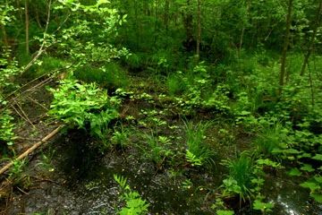
Photo by Josh Mayer
The core and highlight of North Branch Bottoms is the bottomland hardwood forest along the North Branch of the Oconto River. The floodplain forest is dominated by black ash, red maple, and large silver maple with a ground layer of nettles and ostrich fern. Steep, rocky slopes border the floodplain with pockets of fire-scarred hardwoods on the slope with super-canopy white pine found along the river corridor. An isolated stand of remnant old-growth hemlock and American beech forest is included in the complex. Rare plant and bird species are found here.
The understory is dominated by beech seedlings, maple-leaf viburnum, and witch hazel. Other plants include bracken fern, and hog-peanut. Upland stands are primarily red oak, sugar maple, and paper birch with some richer inclusions of sugar maple and basswood. Rare and uncommon species include butternut (Juglans cinerea) and Indian cucumber-root (Medeola virginiana). The rich understory is dominated by hog-peanut with maidenhair fern, lady fern, spikenard, round-lobed hepatica, bloodroot, and large-flowered trillium. A disjunct hemlock stand is found west of the complex. The rare pygmy shrew (Sorex hoyi) has been found just outside the SNA/RNA boundary and sufficient habitat exists within the site to support it. A complete survey may reveal the occurrence of this and other rare species within the site. North Branch Bottoms is owned by the US Forest Service and was designated a State Natural Area in 2007.
Very few State Natural Areas have public facilities, but nearly all are open for a variety of recreational activities as indicated below. Generally, there are no picnic areas, restrooms, or other developments. Parking lots or designated parking areas are noted on individual SNA pages and maps. If a developed trail is present, it will normally be noted on the SNA map and/or under the Maps tab. A compass and topographic map or a GPS unit are useful tools for exploring larger, isolated SNAs.
The good majority of SNAs are isolated and have few or no facilities. Some SNAs have vehicle access lanes or parking lots, but their accessibility may vary depending on weather conditions. Parking lots and lanes are not plowed during winter. Hiking trails may be nonexistent or consist of undeveloped footpaths. A GPS unit or compass and a detailed topographic map are useful tools for exploring larger SNAs.
Non-DNR lands
Entrance fees: For non-DNR-owned SNAs, we are unaware of any vehicle or admission fees. However, please contact the landowner for more information.
Hunting and trapping
Other activities
Other allowable activities such as - but not limited to camping, geocaching and bicycling are determined by the landowner. Please contact them directly or visit their websites for details.
Location
Within the Chequamegon-Nicolet National Forest. Oconto County. T33N-R16E, Section 36. T33-R17E, Section 31. 113 acres.
Driving directions
The site can be accessed from Lakewood, Wisconsin. From the intersection of Highways 32 and F in Lakewood, go north and east on F for 3 miles, then east on FR 2101 (Smyth Road) for 0.3 miles, then south on FR 2330 (Sullivan Springs Road) for 2.4 miles to the North Branch of the Oconto River. The site lies north of the road on either side of the river.
The DNR's state natural areas program is comprised of lands owned by the state, private conservation organizations, municipalities, other governmental agencies, educational institutions and private individuals. While the majority of SNAs are open to the public, access may vary according to individual ownership policies. Public use restrictions may apply due to public safety, or to protect endangered or threatened species or unique natural features. Lands may be temporarily closed due to specific management activities.
Users are encouraged to contact the landowner for more specific details. The data shown on these maps have been obtained from various sources, and are of varying age, reliability, and resolution. The data may contain errors or omissions and should not be interpreted as a legal representation of legal ownership boundaries. To create your custom map where you can zoom to a specific location, please use the DNR's Mapping Application.
North Branch Bottoms is owned by: US Forest Service