No Name Lake
No. 432
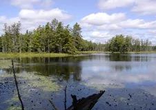
Photo by Linda Parker
No Name Lake is centered around an undeveloped, soft-water seepage lake in a remote setting. While evidence of past logging exists, the area maintains a healthy community gradient from lowland bog to upland, mesic hardwood forest. The lake itself has a highly irregular and hilly shoreline with numerous bays and backwater ponds created by ice-collapsed topography. Lake level fluctuations are common with water levels determined by changes in groundwater levels. On the rolling ground, the moraine is an extensive mature hemlock-white cedar wet-mesic forest with super-canopy white pine. Several small patches of older hemlock forest with super-canopy pines border the lakeshore margins.
An extensive open wetland dominated by sphagnum, sedges, and bog ericads grading into a tamarack swamp occurs on the north side of the lake. Also present is a northern mesic forest with mature, second-growth sugar maple and yellow birch with 10-18" diameter hemlock and scattered white pine. The drier hills are dominated by white ash, sugar maple, and basswood. The closed canopy provides for an open, park-like understory with a sparse shrub layer that includes American fly honeysuckle, mountain maple, and winterberry. Ground flora consists of spinulose wood fern, club mosses, sedges, and grasses. Dominant herbs are wild sarsaparilla and Canada mayflower with bunchberry, mountain wood sorrel, three-leaved goldthread, and fragrant bedstraw.
The ground layer contains a high diversity of Botrychium ferns including the uncommon triangle moonwort (Botrychium lanceolatum var. angustisegmentum). The lake and associated wetland communities appear to have intermittent drainage northeast to the East Fork of the Chippewa River. Wildlife observed using the site include a wide variety of waterfowl and marsh birds, river otters, beavers, kingfishers, saw-whet owls, common loons, and red-tailed hawks. No Name Lake is owned by the U.S. Forest Service and was designated a State Natural Area in 2007. This site is also recognized by the Forest Service as an established Research Natural Area.
Very few State Natural Areas have public facilities, but nearly all are open for a variety of recreational activities as indicated below. Generally, there are no picnic areas, restrooms, or other developments. Parking lots or designated parking areas are noted on individual SNA pages and maps. If a developed trail is present, it will normally be noted on the SNA map and/or under the Maps tab. A compass and topographic map or a GPS unit are useful tools for exploring larger, isolated SNAs.
The good majority of SNAs are isolated and have few or no facilities. Some SNAs have vehicle access lanes or parking lots, but their accessibility may vary depending on weather conditions. Parking lots and lanes are not plowed during winter. Hiking trails may be nonexistent or consist of undeveloped footpaths. A GPS unit or compass and a detailed topographic map are useful tools for exploring larger SNAs.
Non-DNR lands
Entrance fees: For non-DNR-owned SNAs, we are unaware of any vehicle or admission fees. However, please contact the landowner for more information.
Hunting and trapping
Other activities
Other allowable activities such as - but not limited to camping, geocaching and bicycling are determined by the landowner. Please contact them directly or visit their websites for details.
Location
Within the Chequamegon-Nicolet National Forest, Sawyer County. T40N-R3W, Section 6, 7. T40N-R4W, Sections 1, 12. 305 acres.
Driving directions
From the intersection of FS 162 and FS 163, go west on FR 163 approximately 0.6 miles to a gated road FS Trail 221. Go south 0.75 miles to the intersection of FS snowmobile trail 214. Go southwest approximately 0.5 miles into the site. The trail comes within a quarter mile of No Name Lake.
The DNR's state natural areas program is comprised of lands owned by the state, private conservation organizations, municipalities, other governmental agencies, educational institutions and private individuals. While the majority of SNAs are open to the public, access may vary according to individual ownership policies. Public use restrictions may apply due to public safety, or to protect endangered or threatened species or unique natural features. Lands may be temporarily closed due to specific management activities.
Users are encouraged to contact the landowner for more specific details. The data shown on these maps have been obtained from various sources, and are of varying age, reliability, and resolution. The data may contain errors or omissions and should not be interpreted as a legal representation of legal ownership boundaries. To create your custom map where you can zoom to a specific location, please use the DNR's Mapping Application.
No Name Lake is owned by: US Forest Service