Nixon Lake
No. 186
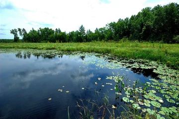
Photo by Josh Mayer
Nixon Lake features a complex of natural features including extensive wet meadow and shrub swamp, conifer swamp, muskeg, and northern dry forest surrounding an undeveloped drainage lake. Bordering Nixon Lake, Nixon Creek, and Partridge Creek is a mostly open shrub-herb wetland of American woolly-fruit sedge, blue-joint grass, bog birch, marsh bellflower, marsh cinquefoil, water hemlock, Virginia water-horehound, and marsh fern. Extensive beds of submerged aquatic vegetation occur in the inlet and outlet streams.
Marsh and bog species including cat-tail, bulrush, sweet fern, white meadowsweet, leather-leaf, and bog rosemary are significant in areas. Tamarack is scattered unevenly throughout the wetland and becomes co-dominant with black spruce away from the lake and streams. On gently rolling pitted sandy outwash northeast of Nixon Lake is a dry forest dominated by jack pine. Associates include red pine, balsam fir, red maple, and black cherry. The understory includes beaked hazelnut, bracken fern, winterberry, blueberry, Canada mayflower, gay wings, and cow-wheat. The 110-acre Nixon Lake is a moderately fertile drainage lake that supports dense beds of aquatic vegetation.
Common species include Robbins pondweed, big-leaf pondweed, floating pondweed, flat-stem pondweed, water-lilies, northern water nymphs, pickerel weed, common waterweed, and wild rice. Nixon Creek, the lake's outlet, empties into the Manitowish Flowage about two miles downstream. The lake and surrounding wetlands are extensively used by numerous water birds including mallards, American black ducks, blue-wing teal, wood duck, mergansers, coots, and Canada geese. Principal fish species are muskie, walleye, large-mouth bass, small-mouth bass, and panfish. Nixon Lake is owned by the DNR and was designated a State Natural Area in 2007.
Very few State Natural Areas have public facilities, but nearly all are open for a variety of recreational activities as indicated below. Generally, there are no picnic areas, restrooms, or other developments. Parking lots or designated parking areas are noted on individual SNA pages and maps. If a developed trail is present, it will normally be noted on the SNA map and/or under the Maps tab. A compass and topographic map or a GPS unit are useful tools for exploring larger, isolated SNAs.
The good majority of SNAs are isolated and have few or no facilities. Some SNAs have vehicle access lanes or parking lots, but their accessibility may vary depending on weather conditions. Parking lots and lanes are not plowed during winter. Hiking trails may be nonexistent or consist of undeveloped footpaths. A GPS unit or compass and a detailed topographic map are useful tools for exploring larger SNAs.
Entrance fees: Except for Parfrey's Glen, the Cambrian Outlook in the Dells of the Wisconsin River, SNAs within State Parks and some within State Forests, all other DNR-owned SNAs do not have any admission fees. For more information, see Wis. Admin. Code NR 45 [exit DNR]. For non-DNR-owned SNAs, we are unaware of any vehicle or admission fees. However, please contact the landowner for more information.
Allowable activities: DNR-owned land
The activities listed below are generally allowed on all DNR-owned SNA lands. Exceptions to this list of public uses, such as SNAs closed to hunting, are noted above and posted with signs on the property site.
- Hiking
- Fishing
- Cross country skiing
- Hunting
- Trapping
- Scientific research (permit required [PDF])
- Outdoor education
- Wild edibles (What is this?)
- Pets (Rules)
- Wildlife viewing
Prohibited activities: all SNAs
Although a handful of sites allow activities like primitive camping (e.g. Lower Chippewa River on sand bars) or horseback riding (e.g. S. Kettle Moraine), the activities listed below are generally prohibited on DNR-owned SNAs.
- Camping and campfires
- Collecting of animals (other than legally harvested species), non-edible fungi, rocks, minerals, fossils, archaeological artifacts, soil, downed wood, or any other natural material, alive or dead.
- Collecting for scientific research requires a permit issued by the DNR
- Collecting of plants including seeds, roots or other non-edible parts of herbaceous plants such as wildflowers or grasses
- Drones: Flying-related activities, including the use of drones, hang-gliders and model airplanes, are prohibited. Permission may be issued by the SNA Program for the use of drones for educational or research purposes
- Geocaching
- Horseback riding
- Rock climbing
- Vehicles, including bicycles, ATVs, aircraft, and snowmobiles except on trails and roadways designated for their use.
For rules governing state-owned SNAs and other state lands, please consult Chapter NR 45 Wis. Admin. Code [exit DNR].
Location
Within the Northern Highland-American Legion State Forest, Vilas County. T42N-R7E, Sections 23, 24, 25. T42N-R8E, Sections 19, 30. 737 acres.
Driving directions
The area is best seen by canoe. From the junction of County K and Nixon Lake Road 5 miles east of Boulder Junction, go north on Nixon Lake Road 1.5 miles to Nixon Creek.
The DNR's state natural areas program is comprised of lands owned by the state, private conservation organizations, municipalities, other governmental agencies, educational institutions and private individuals. While the majority of SNAs are open to the public, access may vary according to individual ownership policies. Public use restrictions may apply due to public safety, or to protect endangered or threatened species or unique natural features. Lands may be temporarily closed due to specific management activities.
Users are encouraged to contact the landowner for more specific details. The data shown on these maps have been obtained from various sources, and are of varying age, reliability, and resolution. The data may contain errors or omissions and should not be interpreted as a legal representation of legal ownership boundaries. To create your custom map where you can zoom to a specific location, please use the DNR's Mapping Application.
Nixon Lake is owned by: Wisconsin DNR