Nine Mile Island
No. 236
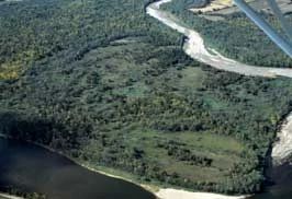
Photo by E. Epstein
Nine Mile Island is located within an extensive river ecosystem that includes the Chippewa River and Nine Mile Slough and features two high-quality native plant communities - oak barrens and floodplain forest. Most of the island is an extensive floodplain forest of silver maple, river birch, green ash, swamp white oak, elms, hackberry, and yellow bud hickory. Understory species include hop hornbeam, common winterberry and herbs such as cut-leaved coneflower, fox, bur and swollen sedges.
On the island's northeast corner the sandy, gravelly soils support excellent oak barrens maintained through the scouring action of floods, and other disturbances, such as fire and grazing. Canopy trees are mostly Hill's oak along with several bur and red oaks. There are also a few scattered red cedar and white pine. In some areas with 70-80% shading, the ground layer still harbors an excellent and diverse prairie component including cream and white wild indigo, stiff goldenrod, bush-clover, rough blazing-star, prairie thistle, whorled milkweed, and asters.
Grasses are dominated by big and little blue-stem with lesser amounts of Indian grass, needle grass, June grass, prairie cord grass, and three species of drop seed. The area has been identified as having an exceptionally diverse fauna with several rare species, including three freshwater mussel species, 9 species of fish, and numerous plants and other animals that prefer unfragmented floodplain forests as habitat. Nine Mile Island is owned by the DNR and was designated a State Natural Area in 1990.
Very few State Natural Areas have public facilities, but nearly all are open for a variety of recreational activities as indicated below. Generally, there are no picnic areas, restrooms, or other developments. Parking lots or designated parking areas are noted on individual SNA pages and maps. If a developed trail is present, it will normally be noted on the SNA map and/or under the Maps tab. A compass and topographic map or a GPS unit are useful tools for exploring larger, isolated SNAs.
The good majority of SNAs are isolated and have few or no facilities. Some SNAs have vehicle access lanes or parking lots, but their accessibility may vary depending on weather conditions. Parking lots and lanes are not plowed during winter. Hiking trails may be nonexistent or consist of undeveloped footpaths. A GPS unit or compass and a detailed topographic map are useful tools for exploring larger SNAs.
Hunting and trapping
Allowable activities: DNR-owned land
The activities listed below are generally allowed on all DNR-owned SNA lands. Exceptions to this list of public uses, such as SNAs closed to hunting, are noted above and posted with signs on the property site.
- Hiking
- Fishing
- Cross country skiing
- Hunting
- Trapping
- Scientific research (permit required [PDF])
- Outdoor education
- Wild edibles (What is this?)
- Pets (Rules)
- Wildlife viewing
Prohibited activities: all SNAs
- Camping and campfires
- Collecting of animals (other than legally harvested species), non-edible fungi, rocks, minerals, fossils, archaeological artifacts, soil, downed wood, or any other natural material, alive or dead.
- Collecting for scientific research requires a permit issued by the DNR
- Collecting of plants including seeds, roots or other non-edible parts of herbaceous plants such as wildflowers or grasses
- Geocaching
- Horseback riding
- Rock climbing
- Vehicles, including bicycles, ATVs, aircraft, and snowmobiles except on trails and roadways designated for their use.
For rules governing state-owned SNAs and other state lands, please consult Chapter NR 45 Wis. Admin. Code [exit DNR].
Location
Dunn and Pepin Counties. T25N-R12W, Section 6. T25N-R13W, Sections 1, 2, 3, 10, 11, 14, 15. T26N-R12W, Section 31. T26N-R13W, Sections 35, 36. 1,592 acres.
Driving directions
The main portion of the natural area is accessible by canoe. From the intersection of State Highways 10 and 85 in Durand, go northeast on 85 for 2.5 miles, then north on M for 2.1 miles to a carry-in canoe landing. Park on the road. Canoe across the river to the eastern tip of the island.
The DNR's state natural areas program is comprised of lands owned by the state, private conservation organizations, municipalities, other governmental agencies, educational institutions and private individuals. While the majority of SNAs are open to the public, access may vary according to individual ownership policies. Public use restrictions may apply due to public safety, or to protect endangered or threatened species or unique natural features. Lands may be temporarily closed due to specific management activities.
Users are encouraged to contact the landowner for more specific details. The data shown on these maps have been obtained from various sources, and are of varying age, reliability, and resolution. The data may contain errors or omissions and should not be interpreted as a legal representation of legal ownership boundaries. To create your custom map where you can zoom to a specific location, please use the DNR's Mapping Application.
Nine Mile Island is owned by: The Wisconsin DNR and Private