Nichols Creek Cedars and Springs
No. 677
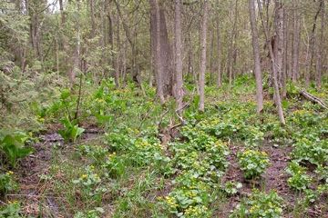
Photo by Wisconsin DNR
Located at the headwaters of Nichols Creek, Nichols Creek Cedars and Springs features a complex of good quality northern wet-mesic forest with springs and spring runs with a small calcareous fen embedded in the lowlands. Both community types are regionally significant for this area. A northeastern-facing morainal slope laced with springs and seepages supports an extensive wet-mesic forest dominated by northern white cedar. Middle and southern units have canopy trees that are mostly 9-15 inches in diameter with a few trees up to 50 inches noted in surveys. The most common canopy associates include yellow birch, paper birch, black ash and basswood. The cedar reproduction is locally strong with patches of large saplings present. Other canopy species are also reproducing.
Characteristic ground layer species include marsh marigold, marsh blue violet, skunk cabbage, jewelweed, bulblet bladder fern, dewberry, ragwort, fowl manna grass and swamp goldenrod. On the upper portions of the slope is a mature mesic to dry-mesic hardwood forest dominated by medium to large sugar maple, red oak, American beech, and basswood. Other canopy trees include white ash, yellow-bud hickory, shagbark hickory, white oak and big-tooth aspen. The herb layer is generally sparse but is richer downslope with wild ginger, blue cohosh and zig-zag goldenrod. Springs are frequent on the lower slopes where the canopy dominance shifts to northern white cedar. Resident birds include ovenbird, eastern wood-pewee, scarlet tanager and blue-winged warbler. The Nichols Creek area has been recognized as a Wetland Gem [PDF, exit DNR]. The site is owned by the DNR and was designated a State Natural Area in 2016.
Very few State Natural Areas have public facilities, but nearly all are open for a variety of recreational activities as indicated below. Generally, there are no picnic areas, restrooms, or other developments. Parking lots or designated parking areas are noted on individual SNA pages and maps. If a developed trail is present, it will normally be noted on the SNA map and/or under the Directions tab. A compass and topographic map or a GPS unit are useful tools for exploring larger, isolated SNAs.
The good majority of SNAs are isolated and have few or no facilities. Some SNAs have vehicle access lanes or parking lots, but their accessibility may vary depending on weather conditions. Parking lots and lanes are not plowed during winter. Hiking trails may be nonexistent or consist of undeveloped footpaths. A GPS unit or compass and a detailed topographic map are useful tools for exploring larger SNAs.
Entrance fees: Except for Parfrey's Glen, the Cambrian Outlook in the Dells of the Wisconsin River, SNAs within State Parks and some within State Forests, all other DNR-owned SNAs do not have any admission fees. For more information, see Wis. Admin. Code NR 45 [exit DNR]. For non-DNR-owned SNAs, we are unaware of any vehicle or admission fees. However, please contact the landowner for more information.
Allowable activities: DNR-owned land
The activities listed below are generally allowed on all DNR-owned SNA lands. Exceptions to this list of public uses, such as SNAs closed to hunting, are noted above and posted with signs on the property site.
- Hiking
- Fishing
- Cross country skiing
- Hunting
- Trapping
- Scientific research (permit required [PDF])
- Outdoor education
- Wild edibles (What is this?)
- Pets (Rules)
- Wildlife viewing
Prohibited activities: all SNAs
Although a handful of sites allow activities like primitive camping (e.g. Lower Chippewa River on sand bars) or horseback riding (e.g. S. Kettle Moraine), the activities listed below are generally prohibited on DNR-owned SNAs.
- Camping and campfires
- Collecting of animals (other than legally harvested species), non-edible fungi, rocks, minerals, fossils, archaeological artifacts, soil, downed wood, or any other natural material, alive or dead.
- Collecting for scientific research requires a permit issued by the DNR
- Collecting of plants including seeds, roots or other non-edible parts of herbaceous plants such as wildflowers or grasses
- Drones: Flying-related activities, including the use of drones, hang-gliders and model airplanes, are prohibited. Permission may be issued by the SNA Program for the use of drones for educational or research purposes
- Geocaching
- Horseback riding
- Rock climbing
- Vehicles, including bicycles, ATVs, aircraft, and snowmobiles except on trails and roadways designated for their use.
For rules governing state-owned SNAs and other state lands, please consult Chapter NR 45 Wis. Admin. Code [exit DNR].
Location
Within Nichols Creek Wildlife Area, Sheboygan County. T14N-R21E, Sections 7, 12, 18. 71 acres.
Driving directions
From the intersection of State Highway 28 and County NN in Cascade, go north on NN 2.1 miles, then west on N 1.1 miles to a DNR parking area.
The DNR's state natural areas program is comprised of lands owned by the state, private conservation organizations, municipalities, other governmental agencies, educational institutions and private individuals. While the majority of SNAs are open to the public, access may vary according to individual ownership policies. Public use restrictions may apply due to public safety, or to protect endangered or threatened species or unique natural features. Lands may be temporarily closed due to specific management activities.
Users are encouraged to contact the landowner for more specific details. The data shown on these maps have been obtained from various sources, and are of varying age, reliability, and resolution. The data may contain errors or omissions and should not be interpreted as a legal representation of legal ownership boundaries. To create your custom map where you can zoom to a specific location, please use the DNR's Mapping Application.
Nichols Creek Cedars and Springs is owned by: Wisconsin DNR