Nemadji River Floodplain Forest
No. 320
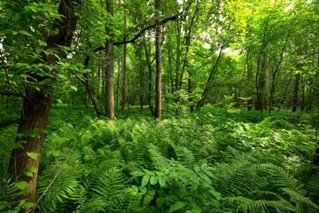
Photo by Josh Mayer
Nemadji River Floodplain Forest, along the banks of the Nemadji River, supports a type of forest unusual in composition and perhaps unique in the state. Floodplain forests are very rare along rivers flowing north into Lake Superior, most being located along major rivers emptying into the Mississippi or Lake Michigan. The natural area lies in a steep-sided valley cut through the Lake Superior clay plain, on terraces about fifteen feet above normal water levels. The forest canopy is composed of black ash, green ash, basswood, red maple, silver maple, balsam poplar, American elm, and bur oak.
Scattered conifers - white spruce, white cedar, white pine, and balsam fir - are also present in the canopy, making for an unusual mix of tree species. The deep, red clay alluvial soils support an exceptionally rich herb layer, with a species composition reminiscent of maple-basswood forests far to the south. Spring ephemerals and their associates are especially well-represented and include sessile-leaved bellwort, downy yellow violet, tall meadow rue, spring beauty, bloodroot, yellow trout lily, wild ginger, Dutchman’s breeches, cut-leaved toothwort, blue cohosh, wild leek, and American starflower. Resident birds include the common raven, Nashville warbler, northern waterthrush, ovenbird, red-eyed vireo, hermit and wood thrush, and rose-breasted grosbeak. Nemadji River Floodplain Forest is owned by Douglas County as a County Forest Special Use Area and was designated a State Natural Area in 1997.
Very few State Natural Areas have public facilities, but nearly all are open for a variety of recreational activities as indicated below. Generally, there are no picnic areas, restrooms, or other developments. Parking lots or designated parking areas are noted on individual SNA pages and maps. If a developed trail is present, it will normally be noted on the SNA map and/or under the Maps tab. A compass and topographic map or a GPS unit are useful tools for exploring larger, isolated SNAs.
The good majority of SNAs are isolated and have few or no facilities. Some SNAs have vehicle access lanes or parking lots, but their accessibility may vary depending on weather conditions. Parking lots and lanes are not plowed during winter. Hiking trails may be nonexistent or consist of undeveloped footpaths. A GPS unit or compass and a detailed topographic map are useful tools for exploring larger SNAs.
Non-DNR lands
Entrance fees: For non-DNR-owned SNAs, we are unaware of any vehicle or admission fees. However, please contact the landowner for more information.
Hunting and trapping
Other activities
Other allowable activities such as - but not limited to camping, geocaching and bicycling are determined by the landowner. Please contact them directly or visit their websites for details.
Location
Within the Douglas County Forest, Douglas County. T48N-R14E, Sections 22, 23, 26, 27. 368 acres.
Driving directions
The natural area can be reached by canoe via the Nemadji River. From the junction of State Highways 105 and 35 in South Superior, go south on 35 about 5.5 miles to the Nemadji River bridge. Canoe downstream 1.3 river miles to the southern boundary of the site. There is no direct public access by land. Permission must be secured from landowners along County Highway C or Darrow Road east of the site to cross their land.
The DNR's state natural areas program is comprised of lands owned by the state, private conservation organizations, municipalities, other governmental agencies, educational institutions and private individuals. While the majority of SNAs are open to the public, access may vary according to individual ownership policies. Public use restrictions may apply due to public safety, or to protect endangered or threatened species or unique natural features. Lands may be temporarily closed due to specific management activities.
Users are encouraged to contact the landowner for more specific details. The data shown on these maps have been obtained from various sources, and are of varying age, reliability, and resolution. The data may contain errors or omissions and should not be interpreted as a legal representation of legal ownership boundaries. To create your custom map where you can zoom to a specific location, please use the DNR's Mapping Application.
Nemadji River Floodplain Forest is owned by: Douglas County