Namekagon Barrens
No. 684
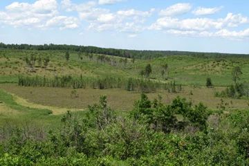
Photo by Wisconsin DNR
Situated on rolling pitted outwash terrain, Namekagon Barrens supports two pine and oak barren communities separated by the Namekagon River. The south unit occurs more on a rolling land form than the north, but both have characteristic soils that are excessively drained sand over outwash. The north unit is drained by two headwater streams that flow into the St. Croix River. Both sites are managed for sharp-tailed grouse and grassland birds resulting in a very sparse canopy cover of 1% or less with scattered areas of dense shrubs consisting of oak grubs, American hazelnut, sweet-fern, New Jersey tea and blueberry.- The ground layer is dominated by various sand prairies grass species such as big blue-stem, little blue-stem, and June grass and a diverse group of forbs like wood lily, rough blazing star, bird's-foot violet, prairie smoke, butterfly weed, hoary puccoon and blue giant hyssop. Each unit also includes numerous open bogs with elements of Poor Fen, Northern Sedge Meadow and Northern Wet Forest. The site is significant in that it protects the globally rare Pine and Oak Barrens communities that are better represented in this landscape than elsewhere in the state and have been identified as a priority in the Northwest Sands Plan, Ecological Landscapes of Wisconsin, the Northwest Sands Corridor Plan, Managing Habitat for Grassland Birds - A guide for Wisconsin, the Wildlife Action Plan, Wisconsin Sharp-tailed Grouse: A Comprehensive Management and Conservation Strategy, the Land Legacy Report and many more. The site supports numerous rare species including birds, invertebrates and plants. It is designated as an Important Bird Area by the Wisconsin Bird Conservation Initiative and is a part of the Great Wisconsin Birding & Nature Trail network. Sharp-tailed grouse viewing is available to the public every spring. To sign up for a blind and to find out about other events, please visit Friends of Namekagon Barrens Wildlife Area [exit DNR]. Namekagon Barrens is owned by the DNR and was designated a State Natural Area in 2017.
Very few State Natural Areas have public facilities, but nearly all are open for a variety of recreational activities as indicated below. Generally, there are no picnic areas, restrooms, or other developments. Parking lots or designated parking areas are noted on individual SNA pages and maps. If a developed trail is present, it will normally be noted on the SNA map and/or under the Maps tab. A compass and topographic map or a GPS unit are useful tools for exploring larger, isolated SNAs.
The good majority of SNAs are isolated and have few or no facilities. Some SNAs have vehicle access lanes or parking lots, but their accessibility may vary depending on weather conditions. Parking lots and lanes are not plowed during winter. Hiking trails may be nonexistent or consist of undeveloped footpaths. A GPS unit or compass and a detailed topographic map are useful tools for exploring larger SNAs.
Entrance fees: Except for Parfrey's Glen, the Cambrian Outlook in the Dells of the Wisconsin River, SNAs within State Parks and some within State Forests, all other DNR-owned SNAs do not have any admission fees. For more information, see Wis. Admin. Code NR 45 [exit DNR]. For non-DNR-owned SNAs, we are unaware of any vehicle or admission fees. However, please contact the landowner for more information.
Allowable activities: DNR-owned land
The activities listed below are generally allowed on all DNR-owned SNA lands. Exceptions to this list of public uses, such as SNAs closed to hunting, are noted above and posted with signs on the property site.
- Hiking
- Fishing
- Cross country skiing
- Hunting
- Trapping
- Scientific research (permit required [PDF])
- Outdoor education
- Wild edibles (What is this?)
- Pets (Rules)
- Wildlife viewing
Prohibited activities: all SNAs
Although a handful of sites allow activities like primitive camping (e.g. Lower Chippewa River on sand bars) or horseback riding (e.g. S. Kettle Moraine), the activities listed below are generally prohibited on DNR-owned SNAs.
- Camping and campfires
- Collecting of animals (other than legally harvested species), non-edible fungi, rocks, minerals, fossils, archaeological artifacts, soil, downed wood, or any other natural material, alive or dead.
- Collecting for scientific research requires a permit issued by the DNR
- Collecting of plants including seeds, roots or other non-edible parts of herbaceous plants such as wildflowers or grasses
- Drones: Flying-related activities, including the use of drones, hang-gliders and model airplanes, are prohibited. Permission may be issued by the SNA Program for the use of drones for educational or research purposes
- Geocaching
- Horseback riding
- Rock climbing
- Vehicles, including bicycles, ATVs, aircraft, and snowmobiles except on trails and roadways designated for their use.
For rules governing state-owned SNAs and other state lands, please consult Chapter NR 45 Wis. Admin. Code [exit DNR].
Location
Within the Namekagon Barrens Wildlife Area, Burnett and Washburn counties. T42N-R13W, Sections 6, 7. T43N-R14W, Sections 1, 2, 10-14, 23, 32, 33. 6,438 acres.
Driving directions
From the intersection of US 53 and State Highway 77 in Minong, go west on 77 0.8 miles, then north on County I for 4 miles, then west on St. Croix Trail for 6 miles where a property sign delineates the boundary of the site. For the south unit: from Danbury, go north on Highway 35 for 2 miles, then east on State Highway 77 for 10.5 miles, then north on Namekagon Trail for 2.5 miles until the pavement ends. The south unit lookout is west of Spring Brook Trail approximately 0.5 miles.
The DNR's state natural areas program is comprised of lands owned by the state, private conservation organizations, municipalities, other governmental agencies, educational institutions and private individuals. While the majority of SNAs are open to the public, access may vary according to individual ownership policies. Public use restrictions may apply due to public safety, or to protect endangered or threatened species or unique natural features. Lands may be temporarily closed due to specific management activities.
Users are encouraged to contact the landowner for more specific details. The data shown on these maps have been obtained from various sources, and are of varying age, reliability, and resolution. The data may contain errors or omissions and should not be interpreted as a legal representation of legal ownership boundaries. To create your custom map where you can zoom to a specific location, please use the DNR's Mapping Application.
Namekagon Barrens is owned by: Wisconsin DNR