Mukwonago River
No. 417
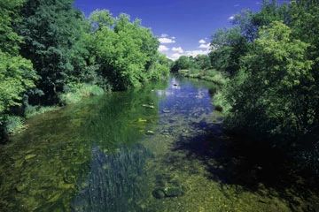
Photo by Thomas A. Meyer/DNR
The Mukwonago River is among the cleanest and most biologically diverse streams in southeastern Wisconsin and provides critical habitat for several threatened, and endangered species of fish and invertebrates. Between Eagle Spring and Phantom Lakes, the river is designated an Exceptional Resource Water, with clear, warm water and a maximum depth of 2 feet. The bottom is composed of sand, rocks and gravel and contains many large glacial boulders.
At least 53 species of fish, including two states state-listed, have been found here. A facile stretch of river from the natural area downstream to its confluence with the Fox River contains the last known self-sustaining population of one of these rare fish in Wisconsin. Among the other fish inhabiting the stream are grass pickerel, rosyfarosy facer, sand shiner, banded killifish, tadpole madtom, rainbow darter, and brook silverside.
Equally diverse is the freshwater mussel fauna. This reach of the Mukwonago is one of the most biologically-rich mussel habitats in the state. Sixteen species are found here, including Wisconsin's only remaining viable population of a state-endangered species. Rare dragonflies are also known from the stream. Beds of coontail and other submerged aquatics are common in the stream, while the banks contain bulrushes, sedges and other emergent plant species. The 44-acre State Natural Area lies within the larger Mukwonago River watershed corridor, a mosaic of natural communities including forest, savanna, wetlands, and lakes. This diverse landscape is home to a wide array of native plants and animals and is an important stopover site for several migratory birds. Mukwonago River is owned by the DNR and was designated a State Natural Area in 2005.
Very few State Natural Areas have public facilities, but nearly all are open for a variety of recreational activities as indicated below. Generally, there are no picnic areas, restrooms, or other developments. Parking lots or designated parking areas are noted on individual SNA pages and maps. Trails, if present, are typically undesignated footpaths. If a developed trail is present, it will normally be noted on the SNA map. A compass and topographic map or a GPS unit are useful tools for exploring larger, isolated SNAs.
The good majority of SNAs are isolated and have few or no facilities. Some SNAs have vehicle access lanes or parking lots, but their accessibility may vary depending on weather conditions. Parking lots and lanes are not plowed during winter. Hiking trails may be nonexistent or consist of undeveloped footpaths. A GPS unit or compass and a detailed topographic map are useful tools for exploring larger SNAs.
Entrance fees: Except for Parfrey's Glen, the Cambrian Outlook in the Dells of the Wisconsin River, SNAs within State Parks and some within State Forests, all other DNR-owned SNAs do not have any admission fees.
Allowable activities: DNR-owned land
In general, the activities listed below are allowed on all DNR-owned SNA lands. Exceptions to this list of public uses, such as SNAs closed to hunting, are noted below and posted with signs on the property site.
- Hiking
- Fishing
- Cross country skiing
- Hunting
- Trapping
- Scientific research (permit required [PDF])
- Outdoor education
- Wild edibles (What is this?)
- Pets (Rules)
- Wildlife viewing
Prohibited activities: all SNAs
- Camping and campfires
- Collecting of animals (other than legally harvested species), non-edible fungi, rocks, minerals, fossils, archaeological artifacts, soil, downed wood, or any other natural material, alive or dead.
- Collecting for scientific research requires a permit issued by the DNR
- Collecting of plants including seeds, roots or other non-edible parts of herbaceous plants such as wildflowers or grasses
- Geocaching
- Horseback riding
- Rock climbing
- Vehicles, including bicycles, ATVs, aircraft, and snowmobiles except on trails and roadways designated for their use.
For rules governing state-owned SNAs and other state lands, please consult Chapter NR 45 Wis. Admin. Code [exit DNR].
Location
Waukesha County. T5N-R18E, Section 36. 44 acres.
Driving directions
From the intersection of County ES and State Highway 83 in Mukwonago, go south on 83 0.8 miles to park and ride on the north side of the highway.
The DNR's state natural areas program is comprised of lands owned by the state, private conservation organizations, municipalities, other governmental agencies, educational institutions and private individuals. While the majority of SNAs are open to the public, access may vary according to individual ownership policies. Public use restrictions may apply due to public safety, or to protect endangered or threatened species or unique natural features. Lands may be temporarily closed due to specific management activities.
Users are encouraged to contact the landowner for more specific details. The data shown on these maps have been obtained from various sources, and are of varying age, reliability, and resolution. The data may contain errors or omissions and should not be interpreted as a legal representation of legal ownership boundaries. To create your custom map where you can zoom to a specific location, please use the DNR's Mapping Application.
Mukwonago River is owned by: Wisconsin DNR
Management objectives and prescriptions
- Read the Southern Region Planning Group Master Plan for details.