Mukwa Bottomland Forest
No. 159
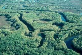
Photo by E. Epstein
Located along the lower Wolf River, Mukwa Bottomland Forest is a diverse southern wet-mesic forest in the floodplain of the Wolf River. Although dominated by silver maple and swamp white oak, small numbers of American elm persist. The trees vary in size from saplings to an occasional specimen more than 30 inches in diameter at breast height.
Areas with smaller trees appear quite natural with no evidence of past logging or grazing. Additional tree species include red elm, black ash, green ash, basswood, bur oak, hackberry, cottonwood, willows, and red maple. The understory has mostly buttonbush and prickly ash as shrubs; the herbaceous layer is dominated by wood nettle but also has Canadian honewort, moneywort, northern bugleweed, tall coneflower, woodland phlox, carrion flower, and bristly greenbriar.
The topography is uneven, the site having been dissected by many old channels and fluctuating water levels. Mukwa Bottomland Forest is owned by the DNR and was designated a State Natural Area in 1980.
Very few State Natural Areas have public facilities, but nearly all are open for a variety of recreational activities as indicated below. Generally, there are no picnic areas, restrooms, or other developments. Parking lots or designated parking areas are noted on individual SNA pages and maps. Trails, if present, are typically undesignated footpaths. If a developed trail is present, it will normally be noted on the SNA map. A compass and topographic map or a GPS unit are useful tools for exploring larger, isolated SNAs.
The good majority of SNAs are isolated and have few or no facilities. Some SNAs have vehicle access lanes or parking lots, but their accessibility may vary depending on weather conditions. Parking lots and lanes are not plowed during winter. Hiking trails may be nonexistent or consist of undeveloped footpaths. A GPS unit or compass and a detailed topographic map are useful tools for exploring larger SNAs.
Entrance fees: Except for Parfrey's Glen, the Cambrian Outlook in the Dells of the Wisconsin River, SNAs within State Parks and some within State Forests, all other DNR-owned SNAs do not have any admission fees.
Allowable activities: DNR-owned land
In general, the activities listed below are allowed on all DNR-owned SNA lands. Exceptions to this list of public uses, such as SNAs closed to hunting, are noted below and posted with signs on the property site.
- Hiking
- Fishing
- Cross country skiing
- Hunting
- Trapping
- Scientific research (permit required [PDF])
- Outdoor education
- Wild edibles (What is this?)
- Pets (Rules)
- Wildlife viewing
Prohibited activities: all SNAs
- Camping and campfires
- Collecting of animals (other than legally harvested species), non-edible fungi, rocks, minerals, fossils, archaeological artifacts, soil, downed wood, or any other natural material, alive or dead.
- Collecting for scientific research requires a permit issued by the DNR
- Collecting of plants including seeds, roots or other non-edible parts of herbaceous plants such as wildflowers or grasses
- Geocaching
- Horseback riding
- Rock climbing
- Vehicles, including bicycles, ATVs, aircraft, and snowmobiles except on trails and roadways designated for their use.
For rules governing state-owned SNAs and other state lands, please consult Chapter NR 45 Wis. Admin. Code [exit DNR].
Location
Within Mukwa Wildlife Area, Waupaca County. T22N-R14E, Sections 15, 16. 171 acres.
Driving directions
The natural area is located 3 miles west of New London. Access is by boat or canoe upstream from a boat landing in NE 1/4 of Sec. 21. To reach the landing from New London, go southwest on County W 0.75 mile, then west on Dey Road 1.5 miles to the Wolf River and boat launch.
The DNR's state natural areas program is comprised of lands owned by the state, private conservation organizations, municipalities, other governmental agencies, educational institutions and private individuals. While the majority of SNAs are open to the public, access may vary according to individual ownership policies. Public use restrictions may apply due to public safety, or to protect endangered or threatened species or unique natural features. Lands may be temporarily closed due to specific management activities.
Users are encouraged to contact the landowner for more specific details. The data shown on these maps have been obtained from various sources, and are of varying age, reliability, and resolution. The data may contain errors or omissions and should not be interpreted as a legal representation of legal ownership boundaries. To create your custom map where you can zoom to a specific location, please use the DNR's Mapping Application.
Mukwa Bottomland Forest is owned by: Wisconsin DNR