Mud Lake - Radley Creek Savanna
No. 224
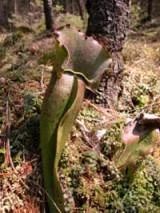
Photo by K. Kirk
Mud Lake is a shallow, hard water lake in a wilderness setting - having no access or human-made developments. The lake covers nearly eleven acres and is only three feet deep. The water is clear and quite fertile, with the major sources being seepage and springs. There is no inlet, but the lake does have a short outlet to Radley Creek. Wild rice dominates the emergent aquatics. Surrounding the lake is a forest of tamarack and poison sumac. The absence of black spruce makes this site very unusual for this locality. The understory is rich in northern wet forest herbs; sundew and pitcher plant are especially numerous. To the north the land rises into an open forest dominated by white and bur oaks, which has several ground layer species that are more typical of prairie. Mud Lake-Radley Creek Savanna is owned by the DNR and was designated a State Natural Area in 1989.
Very few State Natural Areas have public facilities, but nearly all are open for a variety of recreational activities as indicated below. Generally, there are no picnic areas, restrooms, or other developments. Parking lots or designated parking areas are noted on individual SNA pages and maps. Trails, if present, are typically undesignated footpaths. If a developed trail is present, it will normally be noted on the SNA map. A compass and topographic map or a GPS unit are useful tools for exploring larger, isolated SNAs.
The good majority of SNAs are isolated and have few or no facilities. Some SNAs have vehicle access lanes or parking lots, but their accessibility may vary depending on weather conditions. Parking lots and lanes are not plowed during winter. Hiking trails may be nonexistent or consist of undeveloped footpaths. A GPS unit or compass and a detailed topographic map are useful tools for exploring larger SNAs.
Entrance fees: Except for Parfrey's Glen, the Cambrian Outlook in the Dells of the Wisconsin River, SNAs within State Parks, and some within State Forests, all other DNR-owned SNAs do not have any admission fees.
Allowable activities: DNR-owned land
In general, the activities listed below are allowed on all DNR-owned SNA lands. Exceptions to this list of public uses, such as SNAs closed to hunting, are noted below and posted with signs on the property site.
- Hiking
- Fishing
- Cross country skiing
- Hunting
- Trapping
- Scientific research (permit required [PDF])
- Outdoor education
- Wild edibles (What is this?)
- Pets (Rules)
- Wildlife viewing
Prohibited activities: all SNAs
- Camping and campfires
- Collecting of animals (other than legally harvested species), non-edible fungi, rocks, minerals, fossils, archaeological artifacts, soil, downed wood, or any other natural material, alive or dead.
- Collecting for scientific research requires a permit issued by the DNR
- Collecting of plants including seeds, roots or other non-edible parts of herbaceous plants such as wildflowers or grasses
- Geocaching
- Horseback riding
- Rock climbing
- Vehicles, including bicycles, ATVs, aircraft, and snowmobiles except on trails and roadways designated for their use.
For rules governing state-owned SNAs and other state lands, please consult Chapter NR 45 Wis. Admin. Code [exit DNR].
Location
Within Radley Creek Fisheries Area, Waupaca County. T21N-R11E, Section 21. 98 acres.
Driving directions
From Rural go south on State Hwy. 22 three miles to Radley Road, then east on Radley Road 0.5 miles to a parking area. Walk north 0.3 and then east 0.25 miles on state-owned fisheries land to the west boundary.
The DNR's state natural areas program is comprised of lands owned by the state, private conservation organizations, municipalities, other governmental agencies, educational institutions and private individuals. While the majority of SNAs are open to the public, access may vary according to individual ownership policies. Public use restrictions may apply due to public safety, or to protect endangered or threatened species or unique natural features. Lands may be temporarily closed due to specific management activities.
Users are encouraged to contact the landowner for more specific details. The data shown on these maps have been obtained from various sources, and are of varying age, reliability, and resolution. The data may contain errors or omissions and should not be interpreted as a legal representation of legal ownership boundaries. To create your custom map where you can zoom to a specific location, please use the DNR's Mapping Application.
Mud Lake - Radley Creek Savanna is owned by: Wisconsin DNR