Mountain Lake
No. 473
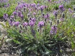
Photo by D. Kind
The primary feature of Mountain Lake is the fluctuating lakeshore habitat that supports one of our rarest plants, a federally threatened species. This Midwest endemic is found nowhere else in the world and is adapted to the sandy shores of shallow seepage lakes whose shorelines fluctuate widely over months or years depending on rainfall and drought patterns. When the shore is exposed, the seeds in the seed bank germinate, grow, flower, and drop seeds.
The plant requires open, sunny habitat and relies on periodic flooding to kill shade-producing trees that invade the shoreline in dry years. The shoreline also provides a habitat for other rare plants. The dramatic upland ridge east of the lake is primarily fire-origin second-growth dry-mesic forest of red oak, white pine and red pine grading into a more mesic forest of sugar maple-basswood as the ridge drops to the north and east. It forms a large block of relatively undisturbed forest in an area that is highly manipulated by production forestry. Mountain Lake is owned by the US Forest Service and was designated a State Natural Area in 2007.
Very few State Natural Areas have public facilities, but nearly all are open for a variety of recreational activities as indicated below. Generally, there are no picnic areas, restrooms, or other developments. Parking lots or designated parking areas are noted on individual SNA pages and maps. Trails, if present, are typically undesignated footpaths. If a developed trail is present, it will normally be noted on the SNA map. A compass and topographic map or a GPS unit are useful tools for exploring larger, isolated SNAs.
The good majority of SNAs are isolated and have few or no facilities. Some SNAs have vehicle access lanes or parking lots, but their accessibility may vary depending on weather conditions. Parking lots and lanes are not plowed during winter. Hiking trails may be nonexistent or consist of undeveloped footpaths. A GPS unit or compass and a detailed topographic map are useful tools for exploring larger SNAs.
Non-DNR lands
Entrance fees: For non-DNR-owned SNAs, we are unaware of any vehicle or admission fees. However, please contact the landowner for more information.
Hunting and trapping
Other activities
Other allowable activities such as - but not limited to camping, geocaching and bicycling are determined by the landowner. Please contact them directly or visit their websites for details.
Location
Within the Chequamegon-Nicolet National Forest. Bayfield County. T45N-R8W, Section 28. 14 acres.
Driving directions
The site is located 5.5 miles west of Drummond, WI. From Drummond, go west on County N 5.5 miles, then northeast on Pigeon Lake Road (FR 394) 0.15 miles to a private gated access lane to the north. Park on the road but please do not block the gate. Walk north on the access lane 0.35 miles into the site. The site lies east and west of the road. No vehicles are allowed on the access lane; however, the landowners do allow for public access to the site on foot. Please do not trespass on surrounding private lands.
The DNR's state natural areas program is comprised of lands owned by the state, private conservation organizations, municipalities, other governmental agencies, educational institutions and private individuals. While the majority of SNAs are open to the public, access may vary according to individual ownership policies. Public use restrictions may apply due to public safety, or to protect endangered or threatened species or unique natural features. Lands may be temporarily closed due to specific management activities.
Users are encouraged to contact the landowner for more specific details. The data shown on these maps have been obtained from various sources, and are of varying age, reliability, and resolution. The data may contain errors or omissions and should not be interpreted as a legal representation of legal ownership boundaries. To create your custom map where you can zoom to a specific location, please use the DNR's Mapping Application.
Mountain Lake is owned by: US Forest Service