Morgan Coulee Prairie
No. 205
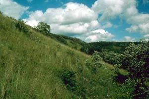
Photo by Eric Epstein
The second largest dry prairie in the west central region, Morgan Coulee Prairie extends for over a half-mile along a steep, south-facing bluff in a coulee opening onto the Rush River valley. The large expanse of relatively undisturbed dry prairie is broken up with scattered islands of bur oak savanna dominated by open-grown, gnarly oaks and shallow wooded draws.
Limestone outcrops are scattered about the area and support a community of lichens and ferns. Dominant grasses include big and little blue-stem, side-oats and hairy grama, Indian grass, needle grass, prairie drop-seed, and several muhly types of grass. The forbs are equally diverse, highlighted by showy species such as asters, milkweeds, white and purple prairie-clover, blazing-star,
Great Plains lady’s-tresses, and prairie larkspur. Wild bergamot, bastard toadflax, and western sunflower are found under the oaks. Much of the prairie is remarkably free of shrubs; those present include hazelnut, bittersweet, smooth sumac, and dogwoods. At the bluff is a southern dry oak forest. Morgan Coulee Prairie is owned by the DNR and was designated a State Natural Area in 1986.
Very few State Natural Areas have public facilities, but nearly all are open for a variety of recreational activities as indicated below. Generally, there are no picnic areas, restrooms, or other developments. Parking lots or designated parking areas are noted on individual SNA pages and maps. Trails, if present, are typically undesignated footpaths. If a developed trail is present, it will normally be noted on the SNA map. A compass and topographic map or a GPS unit are useful tools for exploring larger, isolated SNAs.
The good majority of SNAs are isolated and have few or no facilities. Some SNAs have vehicle access lanes or parking lots, but their accessibility may vary depending on weather conditions. Parking lots and lanes are not plowed during winter. Hiking trails may be nonexistent or consist of undeveloped footpaths. A GPS unit or compass and a detailed topographic map are useful tools for exploring larger SNAs.
Entrance fees: Except for Parfrey's Glen, the Cambrian Outlook in the Dells of the Wisconsin River, SNAs within State Parks and some within State Forests, all other DNR-owned SNAs do not have any admission fees.
Allowable activities: DNR-owned land
In general, the activities listed below are allowed on all DNR-owned SNA lands. Exceptions to this list of public uses, such as SNAs closed to hunting, are noted below and posted with signs on the property site.
- Hiking
- Fishing
- Cross country skiing
- Hunting
- Trapping
- Scientific research (permit required [PDF])
- Outdoor education
- Wild edibles (What is this?)
- Pets (Rules)
- Wildlife viewing
Prohibited activities: all SNAs
- Camping and campfires
- Collecting of animals (other than legally harvested species), non-edible fungi, rocks, minerals, fossils, archaeological artifacts, soil, downed wood, or any other natural material, alive or dead.
- Collecting for scientific research requires a permit issued by the DNR
- Collecting of plants including seeds, roots or other non-edible parts of herbaceous plants such as wildflowers or grasses
- Geocaching
- Horseback riding
- Rock climbing
- Vehicles, including bicycles, ATVs, aircraft, and snowmobiles except on trails and roadways designated for their use.
For rules governing state-owned SNAs and other state lands, please consult Chapter NR 45 Wis. Admin. Code [exit DNR].
Location
Pierce County. T25N-R16W, Section 34. 58 acres.
Driving directions
From the intersection of State Highway 35 and 385th Street (East River Road) on the west end of Maiden Rock, go north on 385th Street for 3.3 miles, then east on 200th Avenue (Morgan Road) for 0.2 miles to the southwest corner of the site. Park along the road.
The DNR's state natural areas program is comprised of lands owned by the state, private conservation organizations, municipalities, other governmental agencies, educational institutions and private individuals. While the majority of SNAs are open to the public, access may vary according to individual ownership policies. Public use restrictions may apply due to public safety, or to protect endangered or threatened species or unique natural features. Lands may be temporarily closed due to specific management activities.
Users are encouraged to contact the landowner for more specific details. The data shown on these maps have been obtained from various sources, and are of varying age, reliability, and resolution. The data may contain errors or omissions and should not be interpreted as a legal representation of legal ownership boundaries. To create your custom map where you can zoom to a specific location, please use the DNR's Mapping Application.
Morgan Coulee Prairie is owned by: Wisconsin DNR
Management objectives and prescriptions
Read the Morgan Coulee Prairie management plan [PDF] for details.