Moose Lake
No. 124
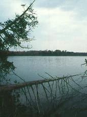
Photo by Thomas A. Meyer/DNR
Moose Lake is an exceptional example of a large, undeveloped lake in a wilderness setting. The 270 softwater water drainage lake has a maximum depth of 12 feet and harbors a diversity of emergent and submerged aquatic plants. It drains into the 13-acre Little Moose Lake. The fishery contains mostly northern lake fishes including a reproducing population of muskellunge.
While a diversity of wetland communities surround the lake, most of the shoreline is covered by a dense thicket of alder and sweet gale; the remainder is predominantly lowland conifer and hardwoods dominated by black spruce, white cedar and black ash. The upland forest surrounding the lake has pockets of higher rocky terrain dominated by sugar maple, basswood, paper birch and balsam fir. Sedge hummocks and alder mark the two small inlet streams and the site also harbors pockets of old-growth hemlock, especially to the south. The high canopy, mature timber and numerous decomposing logs on the forest floor give this site a magnificent virgin appearance.
Dominant trees are hemlock and yellow birch, some more than 2 feet in diameter at breast height. White spruce, white cedar, balsam fir, sugar maple and red maple are found occasionally and the ground layer species composition is representative of northern boreal forest. Some dead-standing hemlock and yellow birch accentuate the unmanaged appearance. Hemlock is reproducing as evidenced by seedlings and saplings. Large numbers of wildlife including black bear, hooded merganser and blue-winged teal use the area. Breeding birds include bald eagle and common loon. Moose Lake is owned by the DNR and was designated a State Natural Area in 1992.
Very few State Natural Areas have public facilities, but nearly all are open for a variety of recreational activities as indicated below. Generally, there are no picnic areas, restrooms, or other developments. Parking lots or designated parking areas are noted on individual SNA pages and maps. Trails, if present, are typically undesignated footpaths. If a developed trail is present, it will normally be noted on the SNA map or in the Directions tab. A compass and topographic map or a GPS unit are useful tools for exploring larger, isolated SNAs.
The good majority of SNAs are isolated and have few or no facilities. Some SNAs have vehicle access lanes or parking lots, but their accessibility may vary depending on weather conditions. Parking lots and lanes are not plowed during winter. Hiking trails may be nonexistent or consist of undeveloped footpaths. A GPS unit or compass and a detailed topographic map are useful tools for exploring larger SNAs.
Entrance fees: Except for Parfrey's Glen, the Cambrian Outlook in the Dells of the Wisconsin River, SNAs within State Parks and some within State Forests, all other DNR-owned SNAs do not have any admission fees.
Allowable activities: DNR-owned land
In general, the activities listed below are allowed on all DNR-owned SNA lands. Exceptions to this list of public uses, such as SNAs closed to hunting, are noted below and posted with signs on the property site.
- Hiking
- Fishing
- Cross country skiing
- Hunting
- Trapping
- Scientific research (permit required [PDF])
- Outdoor education
- Wild edibles (What is this?)
- Pets (Rules)
- Wildlife viewing
Prohibited activities: all SNAs
- Camping and campfires
- Collecting of animals (other than legally harvested species), non-edible fungi, rocks, minerals, fossils, archaeological artifacts, soil, downed wood, or any other natural material, alive or dead.
- Collecting for scientific research requires a permit issued by the DNR
- Collecting of plants including seeds, roots or other non-edible parts of herbaceous plants such as wildflowers or grasses
- Geocaching
- Horseback riding
- Rock climbing
- Vehicles, including bicycles, ATVs, aircraft, and snowmobiles except on trails and roadways designated for their use.
For rules governing state-owned SNAs and other state lands, please consult Chapter NR 45 Wis. Admin. Code [exit DNR].
Location
Iron County. T43N-R2E, Sections 2, 3, 10, 11, 14, 22, 23, 26, 27. 4,293 acres
Driving directions
For boat access, from the intersection of U.S. Highway 51 and County Highway J in Mercer, go north on 51 for 6.6 miles, then west on Moose Lake Road for 2.8 miles les, then north on Kaiser Road for 0.4 miles, then west on Moose Lake for Access Road to a boat ramp. Boat upstream 0.2 miles to the lake. To access Little Moose Lake, continue 0.3 miles west to another boat ramp. For land access, from the junction of Moose Lake Road and Kaiser Road, go north on Kaiser Road for 0.8 miles, then west at the fork on an access road 0.2 miles to a gate. Walk west into the site. For the southern portion, from the junction of Moose Lake and Kaiser Roads, go west on Moose Lake Road 0.4 miles to Moose Creek. Park along the road. The site lies west of the creek. The best old-growth forest is in the SE1/4 SW1/4 of Section 11.
NOTE: The road leading to the boat landings at Moose and Little Moose Lakes is often in a condition that is only passable by four-wheel drive vehicles with high clearance.
The DNR's state natural areas program is comprised of lands owned by the state, private conservation organizations, municipalities, other governmental agencies, educational institutions and private individuals. While the majority of SNAs are open to the public, access may vary according to individual ownership policies. Public use restrictions may apply due to public safety, or to protect endangered or threatened species or unique natural features. Lands may be temporarily closed due to specific management activities.
Users are encouraged to contact the landowner for more specific details. The data shown on these maps have been obtained from various sources, and are of varying age, reliability, and resolution. The data may contain errors or omissions and should not be interpreted as a legal representation of legal ownership boundaries. To create your custom map where you can zoom to a specific location, please use the DNR's Mapping Application.
Moose Lake is owned by the DNR.