Moonlight Bay Bedrock Beach
No. 233
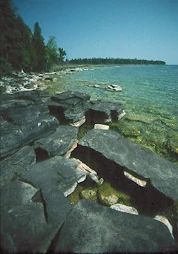
Photo by Thomas A. Meyer/DNR
Moonlight Bay Bedrock Beach protects a 5-acre undisturbed bedrock beach, rare plant and animal communities, geological features, and adjacent boreal forest relict, all of which are dependent on the dynamic influence of Lake Michigan. The primary feature is the dolomite bedrock beach, which is periodically covered and exposed, depending on Lake Michigan water levels.
When exposed, several plants indicative of these calcareous and unstable shorelines colonize the beach, including uncommon species such as small fringed gentian, tufted hair grass, and several sedges (Carex spp.). Ambient shorelines are present as low ledges in the forested portions of the site. The boreal forest is typical of the northeastern Door Peninsula with white cedar, white spruce, paper birch, white pine, hemlock, and balsam fir. Common understory plants are thimbleberry and mountain maple. The ground layer is sparse, with mosses and lichens predominating. Moonlight Bay Bedrock Beach is owned by the DNR and was designated a State Natural Area in 1990.
Very few State Natural Areas have public facilities, but nearly all are open for a variety of recreational activities as indicated below. Generally, there are no picnic areas, restrooms, or other developments. Parking lots or designated parking areas are noted on individual SNA pages and maps. Trails, if present, are typically undesignated footpaths. If a developed trail is present, it will normally be noted on the SNA map. A compass and topographic map or a GPS unit are useful tools for exploring larger, isolated SNAs.
The good majority of SNAs are isolated and have few or no facilities. Some SNAs have vehicle access lanes or parking lots, but their accessibility may vary depending on weather conditions. Parking lots and lanes are not plowed during winter. Hiking trails may be nonexistent or consist of undeveloped footpaths. A GPS unit or compass and a detailed topographic map are useful tools for exploring larger SNAs.
Entrance fees: Except for Parfrey's Glen, the Cambrian Outlook in the Dells of the Wisconsin River, SNAs within State Parks and some within State Forests, all other DNR-owned SNAs do not have any admission fees.
Allowable activities: DNR-owned land
In general, the activities listed below are allowed on all DNR-owned SNA lands. Exceptions to this list of public uses, such as SNAs closed to hunting, are noted below and posted with signs on the property site.
- Hiking
- Fishing
- Cross country skiing
- Hunting
- Trapping
- Scientific research (permit required [PDF])
- Outdoor education
- Wild edibles (What is this?)
- Pets (Rules)
- Wildlife viewing
Prohibited activities: all SNAs
- Camping and campfires
- Collecting of animals (other than legally harvested species), non-edible fungi, rocks, minerals, fossils, archaeological artifacts, soil, downed wood, or any other natural material, alive or dead.
- Collecting for scientific research requires a permit issued by the DNR
- Collecting of plants including seeds, roots or other non-edible parts of herbaceous plants such as wildflowers or grasses
- Geocaching
- Horseback riding
- Rock climbing
- Vehicles, including bicycles, ATVs, aircraft, and snowmobiles except on trails and roadways designated for their use.
For rules governing state-owned SNAs and other state lands, please consult Chapter NR 45 Wis. Admin. Code [exit DNR].
Location
Door County. T30N-R28E, Section 10, SE¼; Section 11, SW¼. 108 acres.
Driving directions
From the intersection of State Highway 57 and County Highway Q north of Baileys Harbor, go northeast on Q 3.5 miles to Cana Island Road, then south 0.9 miles to Bues Point Road. Park SE of the intersection and walk west into the natural area.
The DNR's state natural areas program is comprised of lands owned by the state, private conservation organizations, municipalities, other governmental agencies, educational institutions and private individuals. While the majority of SNAs are open to the public, access may vary according to individual ownership policies. Public use restrictions may apply due to public safety, or to protect endangered or threatened species or unique natural features. Lands may be temporarily closed due to specific management activities.
Users are encouraged to contact the landowner for more specific details. The data shown on these maps have been obtained from various sources, and are of varying age, reliability, and resolution. The data may contain errors or omissions and should not be interpreted as a legal representation of legal ownership boundaries. To create your custom map where you can zoom to a specific location, please use the DNR's Mapping Application.
Moonlight Bay Bedrock Beach is owned by: Wisconsin DNR
Management objectives and prescriptions
Read the Moonlight Bay Bedrock Beach management plan [PDF] for details.