Miscauno Cedar Swamp
No. 92
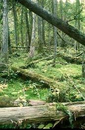
Photo by Thomas A. Meyer/DNR
Miscauno Cedar Swamp features a northern wet-mesic forest in a steep-sided basin along the South Branch of Miscauno Creek. The timber varies from nearly pure stands of pole-sized white cedar to mixtures of white cedar, balsam fir, and black spruce with black ash and elm along the stream. Tamarack snags indicate a former forest of this species and which was undoubtedly logged in the past. The surrounding uplands are mainly an aspen-oak and pine cutover forest.
The groundlayer is rich in smaller orchid species along with one-flowered pyrola, bunchberry, American starflower, yellow blue-bead-lily, gaywings, Canada mayflower, and several ferns. In the numerous headwater springs is a rich flora of mosses and lichens. Breeding bird surveys have shown that uncommon birds such as ravens, hermit thrush, black and white warblers, pine warblers, scarlet tanager, and black-billed cuckoo are found during the nesting season. Although the lowlands have been logged they still retain natural conditions. The swamp was also the site of a 20-year research study looking at the effects of cedar thinning. Miscauno Cedar Swamp is owned by the DNR and was designated in 1971.
Very few State Natural Areas have public facilities, but nearly all are open for a variety of recreational activities as indicated below. Generally, there are no picnic areas, restrooms, or other developments. Parking lots or designated parking areas are noted on individual SNA pages and maps. Trails, if present, are typically undesignated footpaths. If a developed trail is present, it will normally be noted on the SNA map and/or under the "Access" tab. A compass and topographic map or a GPS unit are useful tools for exploring larger, isolated SNAs.
The good majority of SNAs are isolated and have few or no facilities. Some SNAs have vehicle access lanes or parking lots, but their accessibility may vary depending on weather conditions. Parking lots and lanes are not plowed during winter. Hiking trails may be nonexistent or consist of undeveloped footpaths. A GPS unit or compass and a detailed topographic map are useful tools for exploring larger SNAs.
Entrance fees: Excepting Parfrey's Glen, the Cambrian Outlook in the Dells of the Wisconsin River, SNAs within State Parks and some within State Forests, all other DNR-owned SNAs do not have any admission fees.
Allowable activities: DNR-owned land
In general, the activities listed below are allowed on all DNR-owned SNA lands. Exceptions to this list of public uses, such as SNAs closed to hunting, are noted under the "Access" tab above and posted with signs on site.
- Hiking
- Fishing
- Cross country skiing
- Hunting
- Trapping
- Scientific research (permit required [PDF])
- Outdoor education
- Wild edibles (What is this?)
- Pets (Rules)
- Wildlife viewing
Prohibited activities: all SNAs
- Camping and campfires
- Collecting of animals (other than legally harvested species), non-edible fungi, rocks, minerals, fossils, archaeological artifacts, soil, downed wood, or any other natural material, alive or dead.
- Collecting for scientific research requires a permit issued by the DNR
- Collecting of plants including seeds, roots or other non-edible parts of herbaceous plants such as wildflowers or grasses
- Geocaching
- Horseback riding
- Rock climbing
- Vehicles, including bicycles, ATVs, aircraft, and snowmobiles except on trails and roadways designated for their use.
For rules governing state-owned SNAs and other state lands, please consult Chapter NR 45 Wis. Admin. Code [exit DNR].
Location
Within the Miscauno Wildlife Area, Marinette County. T36N-R20E, Sections 13, 14, 23, 24. 442 acres.
Driving directions
From the intersection of U.S. Highway 141 and County Highway Z in Beecher, go east on Z 1.6 miles, then south on Miscauno Lane 0.25 miles to the northwest corner of the site.
The DNR's state natural areas program is comprised of lands owned by the state, private conservation organizations, municipalities, other governmental agencies, educational institutions and private individuals. While the majority of SNAs are open to the public, access may vary according to individual ownership policies. Public use restrictions may apply due to public safety, or to protect endangered or threatened species or unique natural features. Lands may be temporarily closed due to specific management activities.
Users are encouraged to contact the landowner for more specific details. The data shown on these maps have been obtained from various sources, and are of varying age, reliability, and resolution. The data may contain errors or omissions and should not be interpreted as a legal representation of legal ownership boundaries. To create your custom map where you can zoom to a specific location, please use the DNR's Mapping Application.
Miscauno Cedar Swamp is owned by: Wisconsin DNR