Minito Lake
No. 288
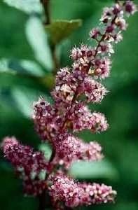
Photo by K. Sytsma and courtesy of the Wisconsin State Herbarium
Minito Lake is a soft water drainage lake bordered by a boggy sedge meadow, conifer swamp, alders, and second-growth northern hardwoods. There is no development along the lakeshore. The 14-acre lake contains a variety of aquatic vegetation including bur-reed, American eelgrass, common bladderwort, wild calla, water smartweed, broad-leaved arrowhead, bulrush, white water-lily, and rattlesnake manna grass. The lake also contains an abundance of freshwater sponges, a good indication of high water quality.
On recently exposed shorelines are such species as blue-joint grass, pond sedge, elliptic spike-rush, oval spike-rush, river horsetail, wild iris, tussock sedge, and beaked sedge. On the lake's northeast edge is a tamarack swamp and the immediate shoreline is covered with a well-developed zone of leather-leaf and steeplebush sedge meadow with associated broad-leaved cat-tails. The meadow then grades into a mixed upland forest located on the surrounding basin slope. Both inlet and outlet streams are a part of the Prairie River. Beavers are known to use this lake. Minito Lake is owned by Langlade County and was designated a State Natural Area in 1995.
Very few State Natural Areas have public facilities, but nearly all are open for a variety of recreational activities as indicated below. Generally, there are no picnic areas, restrooms, or other developments. Parking lots or designated parking areas are noted on individual SNA pages and maps. If a developed trail is present, it will normally be noted on the SNA map and/or under the Maps tab. A compass, topographic map, or GPS unit are useful tools for exploring larger, isolated SNAs.
The good majority of SNAs are isolated and have few or no facilities. Some SNAs have vehicle access lanes or parking lots, but their accessibility may vary depending on weather conditions. Parking lots and lanes are not plowed during winter. Hiking trails may be nonexistent or consist of undeveloped footpaths. A GPS unit or compass and a detailed topographic map are valuable tools for exploring larger SNAs.
Non-DNR lands
Entrance fees: For non-DNR-owned SNAs, we are unaware of any vehicle or admission fees. However, please contact the landowner for more information.
Hunting and trapping
Other activities
Other allowable activities such as - but not limited to camping, geocaching and bicycling are determined by the landowner. Please contact them directly or visit their websites for details.
Location
Within Langlade County Forest, Langlade County. T34N-R10E, Section 20 N½NE¼. 24 acres.
Driving directions
From the intersection of U.S. Highway 45 and County Highway T in Summit Lake, go west on T for 2.7 miles, then north on W. Elcho Road for 3 miles, then east on Pine Lake Road for 1.2 miles. Park on the road and walk overland about 0.3 miles north to Minito Lake.
The DNR's state natural areas program is comprised of lands owned by the state, private conservation organizations, municipalities, other governmental agencies, educational institutions and private individuals. While the majority of SNAs are open to the public, access may vary according to individual ownership policies. Public use restrictions may apply due to public safety, or to protect endangered or threatened species or unique natural features. Lands may be temporarily closed due to specific management activities.
Users are encouraged to contact the landowner for more specific details. The data shown on these maps have been obtained from various sources, and are of varying age, reliability, and resolution. The data may contain errors or omissions and should not be interpreted as a legal representation of legal ownership boundaries. To create your custom map where you can zoom to a specific location, please use the DNR's Mapping Application.
Minito Lake is owned by: Langlade County