Millville Oak Woodlands
No. 682
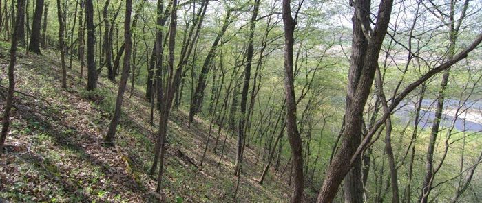
Photo by Thomas A. Meyer/DNR
Millville Oak Woodlands is a phenomenally rich and varied forest complex that includes perhaps the best oak woodland in the state. Situated on a dolomite upland ridge and ravine topography is a moderately dense to semi-open grown canopy of white oak along with lesser amounts of red oak and bur oak. The rare chinquapin oak, here at the northern limits of its range, is also a woodland component. The sub-canopy and sapling layers are moderately dense, dominated primarily by white oak with lesser amounts of red oak, bur oak, bigtooth aspen, American elm, hackberry and sugar maple. Virginia creeper, American hazelnut, poison ivy, and gray dogwood comprise the shrub layer.
The sparse ground layer includes the enchanter's nightshade, bracken fern, false Solomon's seal, Culver's root and wild geranium. A narrow strip of fair-to-good quality oak barrens lies on the upper sand terrace between the western block of floodplain forest and adjacent uplands. Here, scattered small black oaks are present while the ground layer is dominated by native grasses such as big bluestem, switchgrass, little bluestem, June grass and Pennsylvania sedge. Typical forbs include bird's-foot violet, western sunflower, dotted horsemint, leadplant, wild bergamot, prairie bush-clover, goat's-rue, flowering spurge, spiderwort, wild lupine and prairie coreopsis.
Situated along the Wisconsin River is a large floodplain forest dominated by silver maple with hackberry, swamp white oak and green ash on the ridges. The open sloughs are dominated by buttonbush with ground layer species of wood nettle, cut-leaved coneflower, woodland phlox, rough buttercup, fringed loosestrife and Virginia wild-rye. The diversity and connectivity of habitats and connection to other adjacent protected areas make this site one of the best locations for several conservative bird species and many other Species of Greatest Conservation Need. Millville Oak Woodlands is owned by the DNR and was designated a State Natural Area in 2016.
Very few State Natural Areas have public facilities, but nearly all are open for a variety of recreational activities as indicated below. Generally, there are no picnic areas, restrooms, or other developments. Parking lots or designated parking areas are noted on individual SNA pages and maps. Trails, if present, are typically undesignated footpaths. If a developed trail is present, it will normally be noted on the SNA map. A compass and topographic map or a GPS unit are useful tools for exploring larger, isolated SNAs.
The good majority of SNAs are isolated and have few or no facilities. Some SNAs have vehicle access lanes or parking lots, but their accessibility may vary depending on weather conditions. Parking lots and lanes are not plowed during winter. Hiking trails may be nonexistent or consist of undeveloped footpaths. A GPS unit or compass and a detailed topographic map are useful tools for exploring larger SNAs.
Entrance fees: Except for Parfrey's Glen, the Cambrian Outlook in the Dells of the Wisconsin River, SNAs within State Parks and some within State Forests, all other DNR-owned SNAs do not have any admission fees.
Allowable activities: DNR-owned land
In general, the activities listed below are allowed on all DNR-owned SNA lands. Exceptions to this list of public uses, such as SNAs closed to hunting, are noted below and posted with signs on the property site.
- Hiking
- Fishing
- Cross country skiing
- Hunting
- Trapping
- Scientific research (permit required [PDF])
- Outdoor education
- Wild edibles (What is this?)
- Pets (Rules)
- Wildlife viewing
Prohibited activities: all SNAs
- Camping and campfires
- Collecting of animals (other than legally harvested species), non-edible fungi, rocks, minerals, fossils, archaeological artifacts, soil, downed wood, or any other natural material, alive or dead.
- Collecting for scientific research requires a permit issued by the DNR
- Collecting of plants including seeds, roots or other non-edible parts of herbaceous plants such as wildflowers or grasses
- Geocaching
- Horseback riding
- Rock climbing
- Vehicles, including bicycles, ATVs, aircraft, and snowmobiles except on trails and roadways designated for their use.
For rules governing state-owned SNAs and other state lands, please consult Chapter NR 45 Wis. Admin. Code [exit DNR].
Location
Within the Lower Wisconsin State Riverway, Grant County. T7N-R5W, Sections 23, 24, 25, 26, 35, 36. 1,267 acres.
Driving directions
From Millville, go northwest on County Highway C 0.3 miles or 0.6 miles (Winker's Lane) to one of two DNR parking areas.
The DNR's state natural areas program is comprised of lands owned by the state, private conservation organizations, municipalities, other governmental agencies, educational institutions and private individuals. While the majority of SNAs are open to the public, access may vary according to individual ownership policies. Public use restrictions may apply due to public safety, or to protect endangered or threatened species or unique natural features. Lands may be temporarily closed due to specific management activities.
Users are encouraged to contact the landowner for more specific details. The data shown on these maps have been obtained from various sources, and are of varying age, reliability, and resolution. The data may contain errors or omissions and should not be interpreted as a legal representation of legal ownership boundaries. To create your custom map where you can zoom to a specific location, please use the DNR's Mapping Application.
Millville Oak Woodlands is owned by the Wisconsin DNR and The Prairie Enthusiasts.