Millston Sand Barrens
No. 637
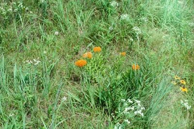
Photo by Eric Epstein
Situated on an area of extensive sandy outwash and punctuated by sandstone outcrops is Millston Sand Barrens – a large expanse of even-aged Hill's oak that originated after an intense fire in 1977. The forest varies from dense and at times impenetrable stands of oak to open areas. Pennsylvania sedge dominates the herbaceous layer although other dry prairie species including wild lupine, prairie violet, prairie alum-root and grasses are also present. Running through the center of the site is a 100-200 foot high sandstone ridge harboring dense stands of oak with scattered small openings that harbor sweet fern, lyrate rock cress, poverty oat grass, false heather, huckleberry, rough blazing star, round-headed bush-clover and early low blueberry. Along the north slope of the ridge is an "amphitheater", a highly diverse bowl-like valley. This 5-acre hillside sand prairie features species such as silky aster, little bluestem, annual false foxglove, evening primrose, prairie coreopsis, sand milkweed, butterfly milkweed, hairy puccoon, prairie phlox and goat's-rue. This site contains an abundant population a rare butterfly and numerous prairie insects. Oak Barrens are one of the rarest natural communities in the U.S. and Jackson County has recognized this site for its ecological values and rare species habitat. Millston Sand Barrens was designated a State Natural Area in 2010.
Very few State Natural Areas have public facilities, but nearly all are open for a variety of recreational activities as indicated below. Generally, there are no picnic areas, restrooms, or other developments. Parking lots or designated parking areas are noted on individual SNA pages and maps. Trails, if present, are typically undesignated footpaths. If a developed trail is present, it will normally be noted on the SNA map. A compass and topographic map or a GPS unit are useful tools for exploring larger, isolated SNAs.
The good majority of SNAs are isolated and have few or no facilities. Some SNAs have vehicle access lanes or parking lots, but their accessibility may vary depending on weather conditions. Parking lots and lanes are not plowed during winter. Hiking trails may be nonexistent or consist of undeveloped footpaths. A GPS unit or compass and a detailed topographic map are useful tools for exploring larger SNAs.
Non-DNR lands
Entrance fees: For non-DNR-owned SNAs, we are unaware of any vehicle or admission fees. However, please contact the landowner for more information.
Hunting and trapping
Other activities
Other allowable activities such as - but not limited to camping, geocaching and bicycling are determined by the landowner. Please contact them directly or visit their websites for details.
Location
Within the Jackson County Forest, Jackson County. T20N-R3W, Sections 1, 2, 11, 12. 181 acres.
Driving directions
From Millston, go 5 miles northwest on Old US Highway 12, then 1.5 miles north, then southeast on Lambert Road. Walk east into the site.
The DNR's state natural areas program is comprised of lands owned by the state, private conservation organizations, municipalities, other governmental agencies, educational institutions and private individuals. While the majority of SNAs are open to the public, access may vary according to individual ownership policies. Public use restrictions may apply due to public safety, or to protect endangered or threatened species or unique natural features. Lands may be temporarily closed due to specific management activities.
Users are encouraged to contact the landowner for more specific details. The data shown on these maps have been obtained from various sources, and are of varying age, reliability, and resolution. The data may contain errors or omissions and should not be interpreted as a legal representation of legal ownership boundaries. To create your custom map where you can zoom to a specific location, please use the DNR's Mapping Application.
Millston Sand Barrens is owned by: Jackson County