Mead Conifer Bogs
No. 373
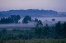
Photo by G. Fuehrer
Mead Conifer Bogs are extensive areas containing northern wet forests dominated by black spruce and tamarack. Both species are reproducing well. The center of the tract is dominated by black spruce, which is gradually replaced by larger tamaracks at the perimeter. Ground cover is a firm carpet of sphagnum moss dominated by leather-leaf and cotton grass.
Poison sumac may be locally abundant. Other species include bog birch, bog-rosemary, Labrador-tea, blueberry, bogbean, yellow blue-bead-lily, bogbean, pitcher plant, bunchberry, Canada mayflower and royal, cinnamon and interrupted fern. Alder-dogwood shrub-carr dominates on the eastern edge near the uplands. Animal life includes bog lemming, Sandhill crane, American redstart, common yellowthroat and Nashville warbler. Mead Conifer Bogs is owned by the DNR and was designated a State Natural Area in 2002.
Very few State Natural Areas have public facilities, but nearly all are open for a variety of recreational activities as indicated below. Generally, there are no picnic areas, restrooms, or other developments. Parking lots or designated parking areas are noted on individual SNA pages and maps. Trails, if present, are typically undesignated footpaths. If a developed trail is present, it will normally be noted on the SNA map and/or under the "Access" tab. A compass and topographic map or a GPS unit are useful tools for exploring larger, isolated SNAs.
The good majority of SNAs are isolated and have few or no facilities. Some SNAs have vehicle access lanes or parking lots, but their accessibility may vary depending on weather conditions. Parking lots and lanes are not plowed during winter. Hiking trails may be nonexistent or consist of undeveloped footpaths. A GPS unit or compass and a detailed topographic map are useful tools for exploring larger SNAs.
Entrance fees: Excepting Parfrey's Glen, the Cambrian Outlook in the Dells of the Wisconsin River, SNAs within State Parks and some within State Forests, all other DNR-owned SNAs do not have any admission fees.
Allowable activities: DNR-owned land
In general, the activities listed below are allowed on all DNR-owned SNA lands. Exceptions to this list of public uses, such as SNAs closed to hunting, are noted under the "Directions" tab above and posted with signs on site.
- Hiking
- Fishing
- Cross country skiing
- Hunting
- Trapping
- Scientific research (permit required [PDF])
- Outdoor education
- Wild edibles (What is this?)
- Pets (Rules)
- Wildlife viewing
Prohibited activities: all SNAs
- Camping and campfires
- Collecting of animals (other than legally harvested species), non-edible fungi, rocks, minerals, fossils, archaeological artifacts, soil, downed wood, or any other natural material, alive or dead.
- Collecting for scientific research requires a permit issued by the DNR
- Collecting of plants including seeds, roots or other non-edible parts of herbaceous plants such as wildflowers or grasses
- Geocaching
- Horseback riding
- Rock climbing
- Vehicles, including bicycles, ATVs, aircraft, and snowmobiles except on trails and roadways designated for their use.
For rules governing state-owned SNAs and other state lands, please consult Chapter NR 45 Wis. Admin. Code [exit DNR].
Location
Within George Mead Wildlife Area. Wood, Portage, and Marathon Counties. East Unit: T25N-R6E, Sections 5, 6, 7. T26N-R6E, Sections 31, 32. West Unit: T25N-R5E, Sections 2, 3, 10. 932 acres.
Driving directions
From the junction of Highway 10 and S in Milladore, go north on S 6.2 miles to the Wildlife Management Area Headquarters. Get a map and directions to the sites. Three parking areas provide access. To access the western portion: From the headquarters, go south on S 0.8 mile to a parking area on the west side of the road. For the eastern portion: Go south on S 0.75, then east on County Line Road about 0.8 miles to a parking area at the end. Alternatively, go south 2.75 miles, then east on H 2 miles, then north on Plum Lane to a parking area at the end of the road.
The DNR's state natural areas program is comprised of lands owned by the state, private conservation organizations, municipalities, other governmental agencies, educational institutions and private individuals. While the majority of SNAs are open to the public, access may vary according to individual ownership policies. Public use restrictions may apply due to public safety, or to protect endangered or threatened species or unique natural features. Lands may be temporarily closed due to specific management activities.
Users are encouraged to contact the landowner for more specific details. The data shown on these maps have been obtained from various sources, and are of varying age, reliability, and resolution. The data may contain errors or omissions and should not be interpreted as a legal representation of legal ownership boundaries. To create your custom map where you can zoom to a specific location, please use the DNR's Mapping Application.
Mead Conifer Bogs is owned by: Wisconsin DNR