Mccarthy Lake And Cedars
No. 293
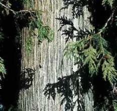
Photo by U.S. Forest Service
McCarthy Lake features undisturbed headwater wetlands, streams and McCarthy Lake, a 42-acre shallow, soft water drainage lake in a wilderness condition. Surrounding the lake are open wetlands dominated by ericaceous bog and northern sedge meadow while the northeast quarter is forested with old-growth white pine. The wetlands are drained by 2 slow, soft water streams, which flow into McCarthy Lake.
The stream outlets are overgrown with alders and flow over a field of large boulders. As such, they have been spared impoundment by beaver and lake water levels are stable. Blunt-leaved pondweed is common with ribbon-leaved pondweed, common pondweed, coon's-tail, and bull-head pond-lily also present.
The cedar swamp is primarily old second growth, dominated by white cedar with lesser amounts of yellow birch, paper birch, white spruce, and red maple. The swamp has recovered well from past disturbance although the numerous regenerating cedar seedlings are unlikely to reach sapling size because of the high white-tailed deer population.
Characteristic herbaceous species include Canada mayflower, blue bead lily, goldthread, and bunchberry. Migratory waterfowl use is high with nesting black ducks, blue-winged teal, and wood ducks. Raptors include bald eagles and sharp-shinned hawks. Mollusks present include the floater and fingernail clams. The site is owned by the U.S. Forest Service and was designated an SNA in 1996. This site is also recognized by the Forest Service as an established Research Natural Area.
Very few State Natural Areas have public facilities, but nearly all are open for a variety of recreational activities as indicated below. Generally, there are no picnic areas, restrooms, or other developments. Parking lots or designated parking areas are noted on individual SNA pages and maps. Trails, if present, are typically undesignated footpaths. If a developed trail is present, it will normally be noted on the SNA map. A compass and topographic map or a GPS unit are useful tools for exploring larger, isolated SNAs.
The good majority of SNAs are isolated and have few or no facilities. Some SNAs have vehicle access lanes or parking lots, but their accessibility may vary depending on weather conditions. Parking lots and lanes are not plowed during winter. Hiking trails may be nonexistent or consist of undeveloped footpaths. A GPS unit or compass and a detailed topographic map are useful tools for exploring larger SNAs.
Non-DNR lands
Entrance fees: For non-DNR-owned SNAs, we are unaware of any vehicle or admission fees. However, please contact the landowner for more information.
Hunting and trapping
Other activities
Other allowable activities such as - but not limited to camping, geocaching and bicycling are determined by the landowner. Please contact them directly or visit their websites for details.
Location
Within Chequamegon-Nicolet National Forest, Ashland County. T43N-R3W, Sections 7, 18. T43N-R4W, Section 12. Ashland County. 472 acres.
Driving directions
From the intersection of State Highways 13 and 77 (east) in Mellen, go south on 77 for 3.9 miles, then west on FR 184 (Conley Road) for 6.2 miles, south on FR 183 for about 3.0 miles, head southwest on unimproved hunter-walking trail along Iron Creek (FR 353) to the lake. To access the cedar swamp, continue on FR 183 for another 4.3 miles, then go west on FR 182 for 3.1 miles, then north on unimproved FR 1333 for about 0.7 miles. Walk west into the site. A compass and map are recommended to navigate this site.
The DNR's state natural areas program is comprised of lands owned by the state, private conservation organizations, municipalities, other governmental agencies, educational institutions and private individuals. While the majority of SNAs are open to the public, access may vary according to individual ownership policies. Public use restrictions may apply due to public safety, or to protect endangered or threatened species or unique natural features. Lands may be temporarily closed due to specific management activities.
Users are encouraged to contact the landowner for more specific details. The data shown on these maps have been obtained from various sources, and are of varying age, reliability, and resolution. The data may contain errors or omissions and should not be interpreted as a legal representation of legal ownership boundaries. To create your custom map where you can zoom to a specific location, please use the DNR's Mapping Application.
Mccarthy Lake And Cedars is owned by: US Forest Service