Mazomanie Bottoms
No. 142
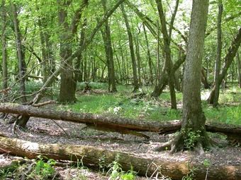
Photo by C. Isenring
Mazomanie Bottoms encompasses a large area of Wisconsin River floodplain forest dissected by old river channels that are dry except during periodic floods. Silver maple, elm, basswood, and ash dominate the forest; other trees include swamp white oak, cottonwood, willow, river birch, and hackberry. Openings in the canopy due to elm mortality have a dense understory of prickly ash, gray dogwood, buckthorn, and young trees. Ridges of sand support oaks but the slough margins are nearly pure silver maple.
Vining plants and lianas are found in abundance: virgin bower, wild yam, moonseed, wild cucumber, woodbine, poison ivy, carrion flower, and grape. Sand bars and ephemeral pools along the river add considerable diversity. The forest harbors thousands of migrating birds. The site has a large woodpecker population and is used in winter by bald eagles. Mazomanie Bottoms is owned by the DNR and was designated a State Natural Area in 1978.
Very few State Natural Areas have public facilities, but nearly all are open for a variety of recreational activities as indicated below. Generally, there are no picnic areas, restrooms, or other developments. Parking lots or designated parking areas are noted on individual SNA pages and maps. Trails, if present, are typically undesignated footpaths. If a developed trail is present, it will normally be noted on the SNA map and/or under the "Access" tab. A compass and topographic map or a GPS unit are useful tools for exploring larger, isolated SNAs.
The good majority of SNAs are isolated and have few or no facilities. Some SNAs have vehicle access lanes or parking lots, but their accessibility may vary depending on weather conditions. Parking lots and lanes are not plowed during winter. Hiking trails may be nonexistent or consist of undeveloped footpaths. A GPS unit or compass and a detailed topographic map are useful tools for exploring larger SNAs.
Entrance fees: Excepting Parfrey's Glen, the Cambrian Outlook in the Dells of the Wisconsin River, SNAs within State Parks and some within State Forests, all other DNR-owned SNAs do not have any admission fees.
Allowable activities: DNR-owned land
In general, the activities listed below are allowed on all DNR-owned SNA lands. Exceptions to this list of public uses, such as SNAs closed to hunting, are noted under the "Access" tab above and posted with signs on site.
- Hiking
- Fishing
- Cross country skiing
- Hunting
- Trapping
- Scientific research (permit required [PDF])
- Outdoor education
- Wild edibles (What is this?)
- Pets (Rules)
- Wildlife viewing
Prohibited activities: all SNAs
- Camping and campfires
- Collecting of animals (other than legally harvested species), non-edible fungi, rocks, minerals, fossils, archaeological artifacts, soil, downed wood, or any other natural material, alive or dead.
- Collecting for scientific research requires a permit issued by the DNR
- Collecting of plants including seeds, roots or other non-edible parts of herbaceous plants such as wildflowers or grasses
- Geocaching
- Horseback riding
- Rock climbing
- Vehicles, including bicycles, ATVs, aircraft, and snowmobiles except on trails and roadways designated for their use.
For rules governing state-owned SNAs and other state lands, please consult Chapter NR 45 Wis. Admin. Code [exit DNR].
Location
Within the Lower Wisconsin Riverway, Dane County. T8N-R6E, Section 6. T9N-R6E, Section 31. 352 acres.
Driving directions
Due to the DNR closure of the Mazo Beach area, access is only available from the south or east off County Y. From the junction of Highways 78 and County Y south of Sauk City in western Dane County, go west and south on Y 5.5 miles to a DNR parking lot west of the road. Walk west along the northside of the ditch 1.5 miles into the natural area. Alternatively, from the DNR parking lot off County Y, continue south on Y for another 0.6 miles, then west on Amenda Road for 2.6 miles to a DNR parking lot. Walk north 0.6 miles (staying to the west of the open field) into the natural area.
The DNR's state natural areas program is comprised of lands owned by the state, private conservation organizations, municipalities, other governmental agencies, educational institutions and private individuals. While the majority of SNAs are open to the public, access may vary according to individual ownership policies. Public use restrictions may apply due to public safety, or to protect endangered or threatened species or unique natural features. Lands may be temporarily closed due to specific management activities.
Users are encouraged to contact the landowner for more specific details. The data shown on these maps have been obtained from various sources, and are of varying age, reliability, and resolution. The data may contain errors or omissions and should not be interpreted as a legal representation of legal ownership boundaries. To create your custom map where you can zoom to a specific location, please use the DNR's Mapping Application.
Mazomanie Bottoms is owned by: Wisconsin DNR