Mayville Ledge Beech-Maple Woods
No. 143
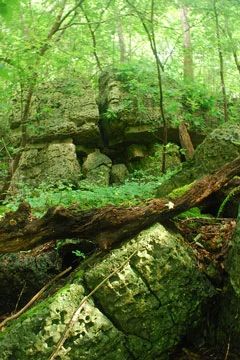
Photo by Joshua Mayer
Mayville Ledge is a one-half-mile exposure of Niagara dolomite escarpment, ranging from 40 to 60 feet in height. The escarpment slope supports an ungrazed forest of sugar maple, basswood, red oak, and American elm. The understory is quite rich in ferns and other deep-shade vegetation, including walking and bulblet ferns.
The level plain above the escarpment supports variable aged woods of ironwood, American beech, sugar maple, and yellowbud hickory. American beech is rare in this location and represents its westernmost range extension in southern Wisconsin. Mayville Ledge Beech-Maple Woods is owned by the University of Wisconsin-Milwaukee and was designated a State Natural Area in 1987.
Very few State Natural Areas have public facilities, but nearly all are open for a variety of recreational activities as indicated below. Generally, there are no picnic areas, restrooms, or other developments. Parking lots or designated parking areas are noted on individual SNA pages and maps. Trails, if present, are typically undesignated footpaths. If a developed trail is present, it will normally be noted on the SNA map. A compass and topographic map or a GPS unit are useful tools for exploring larger, isolated SNAs.
The good majority of SNAs are isolated and have few or no facilities. Some SNAs have vehicle access lanes or parking lots, but their accessibility may vary depending on weather conditions. Parking lots and lanes are not plowed during winter. Hiking trails may be nonexistent or consist of undeveloped footpaths. A GPS unit or compass and a detailed topographic map are useful tools for exploring larger SNAs.
Non-DNR lands
Entrance fees: For non-DNR-owned SNAs, we are unaware of any vehicle or admission fees. However, please contact the landowner for more information.
Hunting and trapping
Note: Hunting is not allowed on this property.
This is a non-DNR-owned SNA: Opportunities for hunting and trapping depend on the landowner. Please contact them directly to find out about their rules for hunting and trapping. You can find a link to other owner websites under the Resources tab. More details regarding allowable uses of this non-DNR-owned SNA may be noted above and posted with signs on the property site.
Other activities
Other allowable activities such as - but not limited to camping, geocaching and bicycling are determined by the landowner. Please contact them directly or visit their websites for details.
Location
Dodge County. T11N-R16E, Section 1. T12N-R16E, Section 36. 66 acres.
Driving directions
From the intersection of Hwys. 67 and 33, go north on Hwy. 67 0.75 miles to the south line of NW1/4 NW1/4 of Sec. 1. The legal access is a 100-foot strip of land, east up the escarpment by footpath.
The DNR's state natural areas program is comprised of lands owned by the state, private conservation organizations, municipalities, other governmental agencies, educational institutions and private individuals. While the majority of SNAs are open to the public, access may vary according to individual ownership policies. Public use restrictions may apply due to public safety, or to protect endangered or threatened species or unique natural features. Lands may be temporarily closed due to specific management activities.
Users are encouraged to contact the landowner for more specific details. The data shown on these maps have been obtained from various sources, and are of varying age, reliability, and resolution. The data may contain errors or omissions and should not be interpreted as a legal representation of legal ownership boundaries. To create your custom map where you can zoom to a specific location, please use the DNR's Mapping Application.
Mayville Ledge Beech-Maple Woods is owned by: The UW Board of Regents