Martin's Woods
No. 350
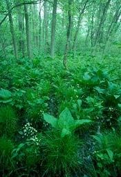
Photo by Thomas A. Meyer/DNR
Martin's Woods features a mesic and wet-mesic forest located on a low, gently sloping terrace adjacent to the Fox River. Sugar maple and basswood dominate the mesic forest while the southern hardwood swamp is dominated by green ash and large swamp white oaks. Associated species include chinquapin oak, basswood, American elm, red maple, black ash, bitternut hickory, and black walnut. The understory includes eastern hop-hornbeam, ironwood, rock elm, gray dogwood, and elderberry.
The uncommon Kentucky coffee tree is also present. Vines are prevalent with Virginia creeper, river grape, wild cucumber, wild yam, and upright carrion flower. Poison ivy is ubiquitous and is found as a vine, shrub, and herb. The herbaceous flora is rich with many uncommon species including American gromwell.
Other species include fragile fern, false mermaid, recurved trillium, declined trillium, spring cress, common great angelica, and hog peanut. Bird species include blue-gray gnatcatcher, veery, wood thrush, wood pewee, ovenbird, scarlet tanager, rose-breasted grosbeak, and indigo bunting. Martin's Woods is owned by the Waukesha Land Conservancy and was designated a State Natural Area in 2002.
Very few State Natural Areas have public facilities, but nearly all are open for a variety of recreational activities as indicated below. Generally, there are no picnic areas, restrooms, or other developments. Parking lots or designated parking areas are noted on individual SNA pages and maps. Trails, if present, are typically undesignated footpaths. If a developed trail is present, it will normally be noted on the SNA map. A compass and topographic map or a GPS unit are useful tools for exploring larger, isolated SNAs.
The good majority of SNAs are isolated and have few or no facilities. Some SNAs have vehicle access lanes or parking lots, but their accessibility may vary depending on weather conditions. Parking lots and lanes are not plowed during winter. Hiking trails may be nonexistent or consist of undeveloped footpaths. A GPS unit or compass and a detailed topographic map are useful tools for exploring larger SNAs.
Non-DNR lands
Entrance fees: For non-DNR-owned SNAs, we are unaware of any vehicle or admission fees. However, please contact the landowner for more information.
Hunting and trapping
Other activities
Other allowable activities such as - but not limited to camping, geocaching and bicycling are determined by the landowner. Please contact them directly or visit their websites for details.
Location
Waukesha County. T5N-R19E, Section 22. 32 acres.
Driving directions
From the junction of Highway 164 (Big Bend Drive) and Edgewood Avenue in Big Bend, go west on Edgewood Avenue for 1.1 miles. Park along the road and walk south into the natural area.
The DNR's state natural areas program is comprised of lands owned by the state, private conservation organizations, municipalities, other governmental agencies, educational institutions and private individuals. While the majority of SNAs are open to the public, access may vary according to individual ownership policies. Public use restrictions may apply due to public safety, or to protect endangered or threatened species or unique natural features. Lands may be temporarily closed due to specific management activities.
Users are encouraged to contact the landowner for more specific details. The data shown on these maps have been obtained from various sources, and are of varying age, reliability, and resolution. The data may contain errors or omissions and should not be interpreted as a legal representation of legal ownership boundaries. To create your custom map where you can zoom to a specific location, please use the DNR's Mapping Application.
Martin's Woods is owned by: Waukesha Land Conservancy