Magnolia Bluff
No. 648
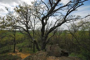
Photo by Josh Mayer
Located in the hilly western upland region of Rock County, Magnolia Bluff marks the second highest point and the only relatively undisturbed cliff in the county. Comprised of Galena dolomite and St. Peter sandstone, the bluff, including its narrow ridgetop, has been deeply incised by natural drainage ways with open and shaded cliffs flanking the sides. Southern dry-mesic forest dominated by black oak covers most of the area with white oak, bur oak, shagbark hickory, and American elm. Paper birch, found at only a handful of locations in the county, is locally abundant on the north-facing slopes.
The cliffs and dry, open slopes above support several plant species including ebony spleenwort, smooth cliffbrake, rusty woodsia, spike-moss, common rockrose, bird's-foot violet, huckleberry, and small skullcap. A state-threatened species is also present here. On the crest and upper slope of the bluff is a small dry prairie remnant with little bluestem, side oats grama grass, rock sandwort, and blue-eyed grass. Magnolia Bluff is owned by Rock County and was designated a State Natural Area in 2011.
Very few State Natural Areas have public facilities, but nearly all are open for a variety of recreational activities as indicated below. Generally, there are no picnic areas, restrooms, or other developments. Parking lots or designated parking areas are noted on individual SNA pages and maps. If a developed trail is present, it will normally be noted on the SNA map and/or under the Maps tab. A compass, topographic map, or GPS unit are useful tools for exploring larger, isolated SNAs.
The good majority of SNAs are isolated and have few or no facilities. Some SNAs have vehicle access lanes or parking lots, but their accessibility may vary depending on weather conditions. Parking lots and lanes are not plowed during winter. Hiking trails may be nonexistent or consist of undeveloped footpaths. A GPS unit or compass and a detailed topographic map are valuable tools for exploring larger SNAs.
Non-DNR lands
Entrance fees: For non-DNR-owned SNAs, we are unaware of any vehicle or admission fees. However, please contact the landowner for more information.
Hunting and trapping
Other activities
Other allowable activities such as - but not limited to camping, geocaching and bicycling are determined by the landowner. Please contact them directly or visit their websites for details.
Location
Within Magnolia Bluff County Park, Rock County. T3N-R10E, Sections 7, 8, 18. 54 acres.
Driving directions
From the intersection of Old Highway 92 and Highway 213 in Evansville, go south on Old 92 for 3.1 miles, then west on Highway 59 for 1 mile, then south on N. Croak Road for 0.5 miles to the park entrance.
The DNR's state natural areas program is comprised of lands owned by the state, private conservation organizations, municipalities, other governmental agencies, educational institutions and private individuals. While the majority of SNAs are open to the public, access may vary according to individual ownership policies. Public use restrictions may apply due to public safety, or to protect endangered or threatened species or unique natural features. Lands may be temporarily closed due to specific management activities.
Users are encouraged to contact the landowner for more specific details. The data shown on these maps have been obtained from various sources, and are of varying age, reliability, and resolution. The data may contain errors or omissions and should not be interpreted as a legal representation of legal ownership boundaries. To create your custom map where you can zoom to a specific location, please use the DNR's Mapping Application.
Magnolia Bluff is owned by: Rock County