Lulu Lake
No. 138
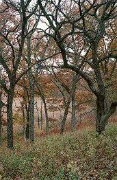
Photo by Thomas A. Meyer/DNR
A slow, no-wake lake, Lulu Lake is an assemblage of exceptionally high-quality and diverse wetland and upland communities on glacial topography in the Kettle Moraine region. Many of the natural communities protected here have been virtually eliminated from southeastern Wisconsin. The focal point of the area is the 95-acre Lulu Lake, a 40-foot deep, hard water drainage kettle lake fed by the Mukwonago River and situated at the base of glacial deposits.
A large wetland complex with patches of calcareous fen and shrub carr embedded within a sedge meadow matrix surrounds the lake on the north and west. An inlet stream contains many rare fen species. A small bog surrounded by tamarack forest is also present along with a good complement of other bog species typically found further north. Scattered patches of prairie grow within the oak opening and woodlands. Lulu Lake is owned by the DNR and The Nature Conservancy and was designated a State Natural Area in 1977.
Very few State Natural Areas have public facilities, but nearly all are open for a variety of recreational activities as indicated below. Generally, there are no picnic areas, restrooms, or other developments. Parking lots or designated parking areas are noted on individual SNA pages and maps. If a developed trail is present, it will normally be noted on the SNA map and/or under the Maps tab. A compass and topographic map or a GPS unit are useful tools for exploring larger, isolated SNAs.
The good majority of SNAs are isolated and have few or no facilities. Some SNAs have vehicle access lanes or parking lots, but their accessibility may vary depending on weather conditions. Parking lots and lanes are not plowed during winter. Hiking trails may be nonexistent or consist of undeveloped footpaths. A GPS unit or compass and a detailed topographic map are useful tools for exploring larger SNAs.
Hunting and trapping
For hunting opportunities on Nature Conservancy land, visit The Nature Conservancy's Deer Management [exit DNR].
Allowable activities: DNR-owned land
The activities listed below are generally allowed on all DNR-owned SNA lands. Exceptions to this list of public uses, such as SNAs closed to hunting, are noted above and posted with signs on the property site.
- Hiking
- Fishing
- Cross country skiing
- Hunting
- Trapping
- Scientific research (permit required [PDF])
- Outdoor education
- Wild edibles (What is this?)
- Pets (Rules)
- Wildlife viewing
Prohibited activities: all SNAs
- Camping and campfires
- Collecting of animals (other than legally harvested species), non-edible fungi, rocks, minerals, fossils, archaeological artifacts, soil, downed wood, or any other natural material, alive or dead.
- Collecting for scientific research requires a permit issued by the DNR
- Collecting of plants including seeds, roots or other non-edible parts of herbaceous plants such as wildflowers or grasses
- Geocaching
- Horseback riding
- Rock climbing
- Vehicles, including bicycles, ATVs, aircraft, and snowmobiles except on trails and roadways designated for their use.
For rules governing state-owned SNAs and other state lands, please consult Chapter NR 45 Wis. Admin. Code [exit DNR].
Location
Walworth and Waukesha Counties. T4N-R17E, Sections 1, 2, 3, 10, 11, 12. T5N-R17E, Sections 35, 36. 1,866 acres (DNR=1,238 and TNC=627).
Driving directions
The natural area can be accessed by land from the east, west, and south and by the water. For southern access: From the intersection of County Highways N and J in Troy Center (4.5 miles northwest of East Troy), go east on J 1.2 miles to a parking area north of the road. For eastern access: From the intersection of Highways N and J, go east on J for 2.2 miles, then go north on County Highway E 0.3 miles to a parking lot west of the road. For the western access: From the intersection of Highways N and J and Bluff Road in Troy Center, go north on Bluff Road for 0.5 miles, then continue north on Nature Road for 0.9 miles to a parking lot west of the road. Lulu Lake is proper and the wetlands are best seen by watercraft via the channel from Eagle Spring Lake to the north. To reach the Eagle Spring boat landing: From the intersection of Highways N and J in Troy Center, go east on J for 2.2 miles, then go north on Highway E for 2.0 miles, then go west on Wambold Road for 0.1 miles to the Eagle Spring Lake Public Boat Launch. Go southwest 0.3 miles to the southwest corner of Eagle Spring Lake and the channel leading to Lulu Lake. Take the channel one mile south to Lulu. For a close-up look at the wetlands, explore the narrow thread of the Mukwonago River where it enters Lulu Lake on its western shore.
The DNR's state natural areas program is comprised of lands owned by the state, private conservation organizations, municipalities, other governmental agencies, educational institutions and private individuals. While the majority of SNAs are open to the public, access may vary according to individual ownership policies. Public use restrictions may apply due to public safety, or to protect endangered or threatened species or unique natural features. Lands may be temporarily closed due to specific management activities.
Users are encouraged to contact the landowner for more specific details. The data shown on these maps have been obtained from various sources, and are of varying age, reliability, and resolution. The data may contain errors or omissions and should not be interpreted as a legal representation of legal ownership boundaries. To create your custom map where you can zoom to a specific location, please use the DNR's Mapping Application.
Lulu Lake is owned by: The Nature Conservancy and the Wisconsin DNR
Management objectives and prescriptions
- Read the Kettle Moraine Waters Master Plan [PDF] for more information.