Lost Lake Esker
No. 462
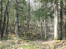
Photo by U.S. Forest Service
Located south of Lost Lake, this complex is centered around a prominent esker, which rises over 80 feet above the surrounding till plain. High-ranking natural communities include several good-quality stands of lowland swamp conifer dominated by white cedar and black ash, extensive tracts of the mature hemlock-hardwood forest of varying degrees of quality (including some small patches of the relatively undisturbed forest), a small acreage of the rich, maple-basswood forest, a large open marsh/wet meadow associated with the upper reaches of Sailor Creek, and several headwaters, morainal stream segments canopied with long-lived species. Together these form a relatively complete complex representing most of the major and minor natural features associated with this land type.
The hemlock-hardwood forest is the dominant forest type occurring on hummocky end moraine and esker topography. Common associates include yellow birch, sugar maple, and red maple. Paper birch, basswood, white ash, red oak, white spruce, and super-canopy white pine are also present. Northern white cedar is frequently found on slopes bordering wetlands and in some ground moraine areas, but never in any great quantity. The forest stands vary in age, quality, and composition with the highest quality stands supporting trees up to 24 inches in diameter and larger under occasional super-canopy white pine. Frequent snags and coarse woody debris contribute to the old-growth structure. The open shrub layer is dominated by American fly honeysuckle, hazelnut, and gooseberry.
The ground flora includes sweet cicely, intermediate wood fern, Canada mayflower, common oak fern, and rough-leaved rice grass. The lowland coniferous forest forms a closed canopy white cedar forest in some areas. Black ash, red maple, yellow birch, hemlock, and balsam fir are common associates. The ground layer is lush and diverse featuring such species as cinnamon fern, sensitive fern, poison ivy, one-sided shin-leaf, alder-leaf buckthorn, dwarf red raspberry, bunchberry, and bryophytes. The understory is dense and consists of mountain maple, speckled alder, common winterberry, and swamp fly honeysuckle.
Fairly extensive bog forests of tamarack and black spruce with red maple, paper birch, yellow birch, and white pine are also present. Northern sedge meadows are common along Sailor Creek, especially where beaver have flooded the hardwood swamps. Common resident birds include winter wren, hermit thrush, red-eyed vireo, ovenbird, blackburnian warbler, and black-throated green warbler. Lost Lake Esker is owned by the US Forest Service and was designated a State Natural Area in 2007.
Very few State Natural Areas have public facilities, but nearly all are open for a variety of recreational activities as indicated below. Generally, there are no picnic areas, restrooms, or other developments. Parking lots or designated parking areas are noted on individual SNA pages and maps. If a developed trail is present, it will normally be noted on the SNA map and/or under the Maps tab. A compass and topographic map or a GPS unit are useful tools for exploring larger, isolated SNAs.
The good majority of SNAs are isolated and have few or no facilities. Some SNAs have vehicle access lanes or parking lots, but their accessibility may vary depending on weather conditions. Parking lots and lanes are not plowed during winter. Hiking trails may be nonexistent or consist of undeveloped footpaths. A GPS unit or compass and a detailed topographic map are useful tools for exploring larger SNAs.
Non-DNR lands
Entrance fees: For non-DNR-owned SNAs, we are unaware of any vehicle or admission fees. However, please contact the landowner for more information.
Hunting and trapping
Other activities
Other allowable activities such as - but not limited to camping, geocaching and bicycling are determined by the landowner. Please contact them directly or visit their websites for details.
Location
Within the Chequamegon-Nicolet National Forest. Taylor County. T32N-R1W, Sections 6, 7, 18. T32N-R2W, Sections 1, 11, 12, 13. 1,264 acres.
Driving directions
From the intersection of Hwy M and Sailor Creek Road (FS 571) just east of Perkinstown, go north on FS 571 approximately 5 miles to the Ice Age Trail crossing. Take the trail east into the site. Or continue to the end of Sailor Creek Road where it intersects with Lost Lake Road. The esker runs northwest of this junction.
The DNR's state natural areas program is comprised of lands owned by the state, private conservation organizations, municipalities, other governmental agencies, educational institutions and private individuals. While the majority of SNAs are open to the public, access may vary according to individual ownership policies. Public use restrictions may apply due to public safety, or to protect endangered or threatened species or unique natural features. Lands may be temporarily closed due to specific management activities.
Users are encouraged to contact the landowner for more specific details. The data shown on these maps have been obtained from various sources, and are of varying age, reliability, and resolution. The data may contain errors or omissions and should not be interpreted as a legal representation of legal ownership boundaries. To create your custom map where you can zoom to a specific location, please use the DNR's Mapping Application.
Lost Lake Esker is owned by: US Forest Service