Lost Canoe
No. 108
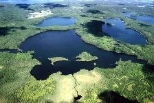
Photo by R. Eckstein
Lost Canoe features a mosaic of natural community types including old-growth mesic forest, northern dry-mesic forest, poor fen, and undeveloped seepage lake. Situated on a 25-acre island in a conifer swamp of black spruce, balsam fir, and tamarack is an old-growth hemlock forest on the southeast shore of Escanaba Lake. Some large white pines were removed long ago but there is no evidence of other disturbances. Hemlock is dominant with little or no reproduction due to large deer populations and possibly heavy shading.
Other canopy species are yellow birch, paper birch, and occasional white pine. The understory and ground layer are depauperate and composed only of scattered balsam fir, pipsissewa, large-leaved aster, snowberry, partridge berry, and club mosses. On the isthmus between Lost Canoe, Pallette, and Escanaba Lakes is a mature hardwood forest dominated by medium-sized red oak, paper birch, and big-tooth aspen. Associated species include white pine, basswood, ironwood, balsam fir, and red maple. Saplings are primarily sugar maple, balsam fir, and occasionally white pine and oak. The moderately dense shrub layer is composed of beaked hazelnut with American fly honeysuckle, and maple-leaved viburnum. Characteristic low shrubs and herbs include early low blueberry, wood anemone, wild sarsaparilla, intermediate wood fern, and grass-leaved ricegrass. Two extensive sedge meadows occur along the upper stretches and headwaters of Stevenson Creek.
The easternmost meadow (poor fen) is dominated by Carex lasiocarpa with white beak rush, pitcher plant, marsh fern, and St. John's-wort. Boggier patches with sphagnum, bog rosemary, and leather leaf are also present. Beds of wild rice, bur reeds, floating-leaved pondweed, ribbon-leaf pondweed, and yellow water lily are found in the creek outlets and springs. The 173-acre Pallette Lake is a deep (65 feet) seepage lake with exceptionally clear water. Birds using the lake and surrounding wetlands include bald eagle, sedge wren, northern harrier, and American black duck. Forest avifauna is a broad-winged hawk, least flycatcher, great-crested flycatcher, scarlet tanager, ovenbird, yellow-throated vireo, white-breasted nuthatch, pileated woodpecker, black-throated green warbler, and pine warbler. Lost Canoe is owned by the DNR and was first designated as Escanaba Lake Hemlocks State Natural Area in 1973. The boundary was later expanded in 2007.
Very few State Natural Areas have public facilities, but nearly all are open for a variety of recreational activities as indicated below. Generally, there are no picnic areas, restrooms, or other developments. Parking lots or designated parking areas are noted on individual SNA pages and maps. If a developed trail is present, it will normally be noted on the SNA map and/or under the Maps tab. A compass and topographic map or a GPS unit are useful tools for exploring larger, isolated SNAs.
The good majority of SNAs are isolated and have few or no facilities. Some SNAs have vehicle access lanes or parking lots, but their accessibility may vary depending on weather conditions. Parking lots and lanes are not plowed during winter. Hiking trails may be nonexistent or consist of undeveloped footpaths. A GPS unit or compass and a detailed topographic map are useful tools for exploring larger SNAs.
Entrance fees: Except for Parfrey's Glen, the Cambrian Outlook in the Dells of the Wisconsin River, SNAs within State Parks and some within State Forests, all other DNR-owned SNAs do not have any admission fees. For more information, see Wis. Admin. Code NR 45 [exit DNR]. For non-DNR-owned SNAs, we are unaware of any vehicle or admission fees. However, please contact the landowner for more information.
Allowable activities: DNR-owned land
The activities listed below are generally allowed on all DNR-owned SNA lands. Exceptions to this list of public uses, such as SNAs closed to hunting, are noted above and posted with signs on the property site.
- Hiking
- Fishing
- Cross country skiing
- Hunting
- Trapping
- Scientific research (permit required [PDF])
- Outdoor education
- Wild edibles (What is this?)
- Pets (Rules)
- Wildlife viewing
Prohibited activities: all SNAs
Although a handful of sites allow activities like primitive camping (e.g. Lower Chippewa River on sand bars) or horseback riding (e.g. S. Kettle Moraine), the activities listed below are generally prohibited on DNR-owned SNAs.
- Camping and campfires
- Collecting of animals (other than legally harvested species), non-edible fungi, rocks, minerals, fossils, archaeological artifacts, soil, downed wood, or any other natural material, alive or dead.
- Collecting for scientific research requires a permit issued by the DNR
- Collecting of plants including seeds, roots or other non-edible parts of herbaceous plants such as wildflowers or grasses
- Drones: Flying-related activities, including the use of drones, hang-gliders and model airplanes, are prohibited. Permission may be issued by the SNA Program for the use of drones for educational or research purposes
- Geocaching
- Horseback riding
- Rock climbing
- Vehicles, including bicycles, ATVs, aircraft, and snowmobiles except on trails and roadways designated for their use.
For rules governing state-owned SNAs and other state lands, please consult Chapter NR 45 Wis. Admin. Code [exit DNR].
Location
Within the Northern Highland-American Legion State Forest, Vilas County. T41N-R7E, Sections 1, 2, 3. T42N-R7E, Sections 34, 35. 1,119 acres.
Driving directions
From the intersection of Highways M and K in Boulder Junction, go south on M for 4.3 miles, then east on Nebish Road3.4 miles, then north for 0.2 miles to the boat landing on Escanaba Lake. Walk north and east along the shore about 0.75 miles to the old-growth hemlocks or walk north and west along the shore about 1 mile to Pallette Lake and the hardwood forest.
The DNR's state natural areas program is comprised of lands owned by the state, private conservation organizations, municipalities, other governmental agencies, educational institutions and private individuals. While the majority of SNAs are open to the public, access may vary according to individual ownership policies. Public use restrictions may apply due to public safety, or to protect endangered or threatened species or unique natural features. Lands may be temporarily closed due to specific management activities.
Users are encouraged to contact the landowner for more specific details. The data shown on these maps have been obtained from various sources, and are of varying age, reliability, and resolution. The data may contain errors or omissions and should not be interpreted as a legal representation of legal ownership boundaries. To create your custom map where you can zoom to a specific location, please use the DNR's Mapping Application.
Lost Canoe is owned by: Wisconsin DNR