Little Wolf River
No. 388
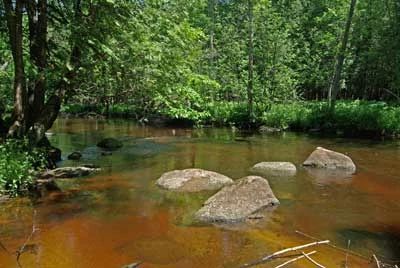
Photo by Thomas A. Meyer/DNR
Little Wolf River contains an unaltered stretch of the Little Wolf River and its springs, seeps, and tributaries that traverse the area. A narrow corridor of floodplain sedge meadow and black ash swamp flanks the river. At this location, the Little Wolf River is a high-quality trout stream running fast and clear. The site also harbors an unfragmented block of northern wet-mesic forest dominated by white cedar with balsam fir, yellow birch, hemlock, and American elm. Numerous large boulders are strewn about the area.
The ground flora is lush and dense with several species more typical of southern Wisconsin forested communities. Common species include lady fern, bulblet fern, Jack-in-the-pulpit, wild sarsaparilla, Michigan lily, alpine enchanter's nightshade, and several sedges. Tag alder and black ash saplings are abundant in the tall shrub layer while swamp dewberry dominates the lower shrub layer. An elevated island of northern mesic forest contains large hemlock (up to 24" diameter), red oak, and yellow birch. The uplands to the west are dominated by hemlock with white pine, yellow birch, and some red oak. Red elderberry and raspberry dominate the shrub layer.
Old cut and burned hemlock stumps indicate the area may have been impacted during the original logging era but is regenerating well today. Birds include broad-winged hawks, great-horned owls, great blue herons, black-billed cuckoos, ovenbird, and winter wren. The property was donated to the DNR by Jerry and Jill Martin. Little Wolf River is owned by the DNR and was designated a State Natural Area in 2002.
Very few State Natural Areas have public facilities, but nearly all are open for a variety of recreational activities as indicated below. Generally, there are no picnic areas, restrooms, or other developments. Parking lots or designated parking areas are noted on individual SNA pages and maps. If a developed trail is present, it will normally be noted on the SNA map and/or under the Maps tab. A compass and topographic map or a GPS unit are useful tools for exploring larger, isolated SNAs.
The good majority of SNAs are isolated and have few or no facilities. Some SNAs have vehicle access lanes or parking lots, but their accessibility may vary depending on weather conditions. Parking lots and lanes are not plowed during winter. Hiking trails may be nonexistent or consist of undeveloped footpaths. A GPS unit or compass and a detailed topographic map are useful tools for exploring larger SNAs.
Entrance fees: Except for Parfrey's Glen, the Cambrian Outlook in the Dells of the Wisconsin River, SNAs within State Parks and some within State Forests, all other DNR-owned SNAs do not have any admission fees. For more information, see Wis. Admin. Code NR 45 [exit DNR]. For non-DNR-owned SNAs, we are unaware of any vehicle or admission fees. However, please contact the landowner for more information.
Allowable activities: DNR-owned land
The activities listed below are generally allowed on all DNR-owned SNA lands. Exceptions to this list of public uses, such as SNAs closed to hunting, are noted above and posted with signs on the property site.
- Hiking
- Fishing
- Cross country skiing
- Hunting
- Trapping
- Scientific research (permit required [PDF])
- Outdoor education
- Wild edibles (What is this?)
- Pets (Rules)
- Wildlife viewing
Prohibited activities: all SNAs
Although a handful of sites allow activities like primitive camping (e.g. Lower Chippewa River on sand bars) or horseback riding (e.g. S. Kettle Moraine), the activities listed below are generally prohibited on DNR-owned SNAs.
- Camping and campfires
- Collecting of animals (other than legally harvested species), non-edible fungi, rocks, minerals, fossils, archaeological artifacts, soil, downed wood, or any other natural material, alive or dead.
- Collecting for scientific research requires a permit issued by the DNR
- Collecting of plants including seeds, roots or other non-edible parts of herbaceous plants such as wildflowers or grasses
- Drones: Flying-related activities, including the use of drones, hang-gliders and model airplanes, are prohibited. Permission may be issued by the SNA Program for the use of drones for educational or research purposes
- Geocaching
- Horseback riding
- Rock climbing
- Vehicles, including bicycles, ATVs, aircraft, and snowmobiles except on trails and roadways designated for their use.
For rules governing state-owned SNAs and other state lands, please consult Chapter NR 45 Wis. Admin. Code [exit DNR].
Location
Waupaca County. T25N-R11E, Section 20. 161 acres.
Driving directions
The natural is only accessible at this time by water via the Little Wolf River. From the junction of Main Street and Highway 66 in Rosholt, go east on Highway 66 for 2 miles, then east on Highway 49 for 0.3 miles, then north and east on County Highway NN for 2.7 miles, then north on County Highway P for 0.25 miles, then east on Wolf River Road 1.5 miles to the bridge spanning the Little Wolf River. Paddle downstream 0.9 river miles to the northern boundary of the natural area. The nearest take-out point is another 2 miles downstream at the Ness Road bridge.
The DNR's state natural areas program is comprised of lands owned by the state, private conservation organizations, municipalities, other governmental agencies, educational institutions and private individuals. While the majority of SNAs are open to the public, access may vary according to individual ownership policies. Public use restrictions may apply due to public safety, or to protect endangered or threatened species or unique natural features. Lands may be temporarily closed due to specific management activities.
Users are encouraged to contact the landowner for more specific details. The data shown on these maps have been obtained from various sources, and are of varying age, reliability, and resolution. The data may contain errors or omissions and should not be interpreted as a legal representation of legal ownership boundaries. To create your custom map where you can zoom to a specific location, please use the DNR's Mapping Application.
Little Wolf River is owned by: Wisconsin DNR