Lauterman Lake
No. 451
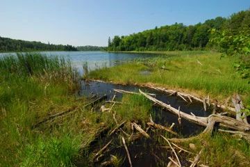
Photo by Josh Mayer
Lauterman Lake features an older-growth mesic hardwood forest with a hemlock component situated on rich silt loam soils on a rolling pitted outwash plain. The site's rich silt loam soils combined with good drainage support an unusual concentration of good quality hardwood stands. The site is divided into three natural divisions: east of Lauterman Lake has rolling topography; the section between Lauterman Lake and Little Porcupine Lake is more rugged with hummocks and steep slopes; and the north end of an extensive braided esker system enters the complex to the south of Little Porcupine Lake.
The braided esker system is dominated by sugar maple with yellow birch, basswood, and hemlock. Understory species include rock elm and eastern hop hornbeam. The richest stands are found to the south of Little Porcupine Lake in the flat area bordering the lacustrine zone. Here Virginia water-leaf and wood nettle are abundant in the understory and coarse woody debris is relatively common. Other species include wild licorice, maidenhair fern, wild leek, large-flowered bellwort, bloodroot, and blue cohosh. This site is an important landscape link between the Whisker Lake Wilderness and Kieper Creek Special Management and Old Growth Area. Lauterman Lake is owned by the US Forest Service and was designated a State Natural Area in 2007.
Very few State Natural Areas have public facilities, but nearly all are open for a variety of recreational activities as indicated below. Generally, there are no picnic areas, restrooms, or other developments. Parking lots or designated parking areas are noted on individual SNA pages and maps. If a developed trail is present, it will normally be noted on the SNA map and/or under the Maps tab. A compass and topographic map or a GPS unit are useful tools for exploring larger, isolated SNAs.
The good majority of SNAs are isolated and have few or no facilities. Some SNAs have vehicle access lanes or parking lots, but their accessibility may vary depending on weather conditions. Parking lots and lanes are not plowed during winter. Hiking trails may be nonexistent or consist of undeveloped footpaths. A GPS unit or compass and a detailed topographic map are useful tools for exploring larger SNAs.
Non-DNR lands
Entrance fees: For non-DNR-owned SNAs, we are unaware of any vehicle or admission fees. However, please contact the landowner for more information.
Hunting and trapping
Other activities
Other allowable activities such as - but not limited to camping, geocaching and bicycling are determined by the landowner. Please contact them directly or visit their websites for details.
Location
Within the Chequamegon-Nicolet National Forest. Florence County. T40N-R16E, Sections 28-32. 1,109 acres.
Driving directions
From Florence, go west on State Highway 70 about 12 miles to the north boundary of the site. FR 2154 and FR 2553 provide interior access to the site.
The DNR's state natural areas program is comprised of lands owned by the state, private conservation organizations, municipalities, other governmental agencies, educational institutions and private individuals. While the majority of SNAs are open to the public, access may vary according to individual ownership policies. Public use restrictions may apply due to public safety, or to protect endangered or threatened species or unique natural features. Lands may be temporarily closed due to specific management activities.
Users are encouraged to contact the landowner for more specific details. The data shown on these maps have been obtained from various sources, and are of varying age, reliability, and resolution. The data may contain errors or omissions and should not be interpreted as a legal representation of legal ownership boundaries. To create your custom map where you can zoom to a specific location, please use the DNR's Mapping Application.
Lauterman Lake is owned by: US Forest Service