LaFave Swamp
No. 492
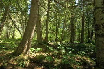
Photo by Josh Mayer
LaFave Swamp features an older northern wet-mesic forest dominated by white cedar with black spruce and tamarack. Coarse woody debris is common. Most of the cedar is less than 12 inches in diameter, although individuals up to 20 inches in diameter are scattered throughout the site. Hemlock, black ash, red maple and paper birch are also present in the overstory. A strong red maple and alder sapling/shrub layer is present in the western part of the natural area but is absent in areas where white cedar is more common and casts a dense shade.
The understory is rich in mosses, lichens, liverworts, and ferns with goldthread, fringed polygola, naked miterwort, and other characteristic species present. White adder's mouth, a small, bog orchid found in conifer swamps, has also been found here. A cool, unnamed headwater creek meanders through the site and flows into the North Fork Thunder River, an outstanding/exceptional resource water and Class I trout stream. LaFave Swamp is owned by the U.S. Forest Service and was designated a State Natural Area in 2007.
Very few State Natural Areas have public facilities, but nearly all are open for a variety of recreational activities as indicated below. Generally, there are no picnic areas, restrooms, or other developments. Parking lots or designated parking areas are noted on individual SNA pages and maps. If a developed trail is present, it will normally be noted on the SNA map and/or under the Maps tab. A compass and topographic map or a GPS unit are useful tools for exploring larger, isolated SNAs.
The good majority of SNAs are isolated and have few or no facilities. Some SNAs have vehicle access lanes or parking lots, but their accessibility may vary depending on weather conditions. Parking lots and lanes are not plowed during winter. Hiking trails may be nonexistent or consist of undeveloped footpaths. A GPS unit or compass and a detailed topographic map are useful tools for exploring larger SNAs.
Non-DNR lands
Entrance fees: For non-DNR-owned SNAs, we are unaware of any vehicle or admission fees. However, please contact the landowner for more information.
Hunting and trapping
Other activities
Other allowable activities such as - but not limited to camping, geocaching and bicycling are determined by the landowner. Please contact them directly or visit their websites for details.
Location
Within the Chequamegon-Nicolet National Forest, Oconto County. T33N-R17E, Sections 26, 35. 125 acres.
Driving directions
From the intersection of State Highway 32 and County Highway W in Mountain, go east on County W for 8.5 miles, then north on FR 2101 (La Fave Road) for 4.6 miles. Walk west into the site.
The DNR's state natural areas program is comprised of lands owned by the state, private conservation organizations, municipalities, other governmental agencies, educational institutions and private individuals. While the majority of SNAs are open to the public, access may vary according to individual ownership policies. Public use restrictions may apply due to public safety, or to protect endangered or threatened species or unique natural features. Lands may be temporarily closed due to specific management activities.
Users are encouraged to contact the landowner for more specific details. The data shown on these maps have been obtained from various sources, and are of varying age, reliability, and resolution. The data may contain errors or omissions and should not be interpreted as a legal representation of legal ownership boundaries. To create your custom map where you can zoom to a specific location, please use the DNR's Mapping Application.
LaFave Swamp is owned by: US Forest Service