Koro Railroad Prairie
No. 225
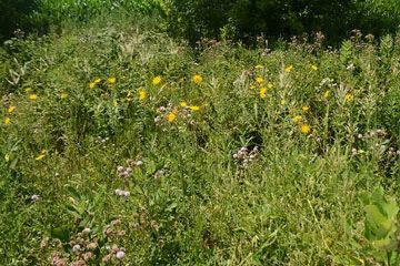
Photo by Josh Mayer
Koro Prairie features a stretch of high-quality mesic prairie with many species of native prairie plants. Dominated by big bluestem, this site contains other common mesic prairie species such as switchgrass, New Jersey tea, prairie dock, stiff goldenrod, and spiderwort. This remnant is especially noteworthy because of its location at the northeastern edge of the prairie-oak savanna region in Wisconsin. The site runs along an abandoned railroad right-of-way and frequent fires sparked by the trains helped maintain the fire-adapted prairie vegetation. Other species include mountain mint, shooting star, narrow-leaved loosestrife, Turk's cap lily, culver's root, and Riddell's goldenrod. Koro Prairie is owned by Winnebago County and was designated a State Natural Area in 1990.
Very few State Natural Areas have public facilities, but nearly all are open for a variety of recreational activities as indicated below. Generally, there are no picnic areas, restrooms, or other developments. Parking lots or designated parking areas are noted on individual SNA pages and maps. If a developed trail is present, it will normally be noted on the SNA map and/or under the Maps tab. A compass and topographic map or a GPS unit are useful tools for exploring larger, isolated SNAs.
The good majority of SNAs are isolated and have few or no facilities. Some SNAs have vehicle access lanes or parking lots, but their accessibility may vary depending on weather conditions. Parking lots and lanes are not plowed during winter. Hiking trails may be nonexistent or consist of undeveloped footpaths. A GPS unit or compass and a detailed topographic map are useful tools for exploring larger SNAs.
Non-DNR lands
Entrance fees: For non-DNR-owned SNAs, we are unaware of any vehicle or admission fees. However, please contact the landowner for more information.
Hunting and trapping
Other activities
Other allowable activities such as - but not limited to camping, geocaching and bicycling are determined by the landowner. Please contact them directly or visit their websites for details.
Location
Along the Mascoutin Valley State Trail, Winnebago County. T17N-R14E, Section 17 W½SW¼. 3 acres.
Driving directions
From the intersection of County Highways V and E just west of Rush Lake, go west on V for one mile, then north on Koro Road 1.25 miles to the Winnebago County Recreational Trail. The site starts at the road and continues east along the trail for 0.4 miles.
The DNR's state natural areas program is comprised of lands owned by the state, private conservation organizations, municipalities, other governmental agencies, educational institutions and private individuals. While the majority of SNAs are open to the public, access may vary according to individual ownership policies. Public use restrictions may apply due to public safety, or to protect endangered or threatened species or unique natural features. Lands may be temporarily closed due to specific management activities.
Users are encouraged to contact the landowner for more specific details. The data shown on these maps have been obtained from various sources, and are of varying age, reliability, and resolution. The data may contain errors or omissions and should not be interpreted as a legal representation of legal ownership boundaries. To create your custom map where you can zoom to a specific location, please use the DNR's Mapping Application.
Koro Railroad Prairie is owned by: Winnebago County