Kohler-Peet Barrens
No. 152
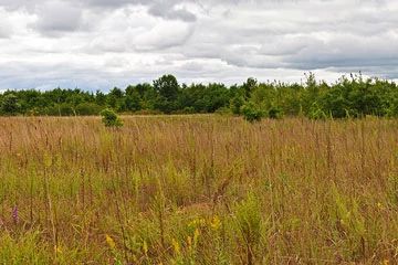
Photo by Aaron Carlson
Kohler-Peet Barrens is a nearly flat expanse of sandy, open barrens situated within the vast glacial outwash deposits of northwestern Wisconsin and adjacent to the steep-walled St. Croix River Valley. Historically, this region supported Pine Barrens vegetation, which burned repeatedly. Today, Hill's oak grubs, jack pine, quaking aspen, and pin cherry are the common trees, and many of the oaks have multiple trunks and bushy sprouts, the result of prescribed burning used to maintain the open barrens. The barrens flora is diverse, with many species of prairies, barrens and bracken grassland communities.
Four plant species with Great Plains distribution - blue giant hyssop (Agastache foeniculum), autumn onion (Allium stellatum), Carolina larkspur (Delphinium carolinianum) and hairy four-o'clock (Mirabilis hirsuta) - are found here at their northeastern range limit. Common shrub species include beaked and American hazelnut, New Jersey tea, and prairie red-root. Many rare and uncommon animals of open habitats are found here, including the eastern bluebird, vesper sparrow and field sparrow. Kohler-Peet Barrens is owned by the DNR and was designated a State Natural Area in 1979.
Very few State Natural Areas have public facilities, but nearly all are open for a variety of recreational activities, as indicated below. Generally, there are no picnic areas, restrooms, or other developments. Parking lots or designated parking areas are noted on individual SNA pages and maps. If a developed trail is present, it will normally be noted on the SNA map and/or under the Maps tab. A compass and topographic map or a GPS unit are useful tools for exploring larger, isolated SNAs.
The good majority of SNAs are isolated and have few or no facilities. Some SNAs have vehicle access lanes or parking lots, but their accessibility may vary depending on weather conditions. Parking lots and lanes are not plowed during winter. Hiking trails may be nonexistent or consist of undeveloped footpaths. A GPS unit or compass and a detailed topographic map are useful tools for exploring larger SNAs.
Entrance fees: Except for Parfrey's Glen, the Cambrian Outlook in the Dells of the Wisconsin River, SNAs within State Parks and some within State Forests, all other DNR-owned SNAs do not have any admission fees. For more information, see Wis. Admin. Code NR 45 [exit DNR]. For non-DNR-owned SNAs, we are unaware of any vehicle or admission fees. However, please contact the landowner for more information.
Allowable activities: DNR-owned land
The activities listed below are generally allowed on all DNR-owned SNA lands. Exceptions to this list of public uses, such as SNAs closed to hunting, are noted above and posted with signs on the property site.
- Hiking
- Fishing
- Cross country skiing
- Hunting
- Trapping
- Scientific research (permit required [PDF])
- Outdoor education
- Wild edibles (What is this?)
- Pets (Rules)
- Wildlife viewing
Prohibited activities: all SNAs
Although a handful of sites allow activities like primitive camping (e.g., Lower Chippewa River on sand bars) or horseback riding (e.g., S. Kettle Moraine), the activities listed below are generally prohibited on DNR-owned SNAs.
- Camping and campfires
- Collecting of animals (other than legally harvested species), non-edible fungi, rocks, minerals, fossils, archaeological artifacts, soil, downed wood, or any other natural material, alive or dead.
- Collecting for scientific research requires a permit issued by the DNR
- Collecting of plants, including seeds, roots or other non-edible parts of herbaceous plants such as wildflowers or grasses
- Drones: Flying-related activities, including the use of drones, hang-gliders and model airplanes, are prohibited. Permission may be issued by the SNA Program for the use of drones for educational or research purposes
- Geocaching
- Horseback riding
- Rock climbing
- Vehicles, including bicycles, ATVs, aircraft, and snowmobiles, except on trails and roadways designated for their use.
For rules governing state-owned SNAs and other state lands, please consult Chapter NR 45 Wis. Admin. Code [exit DNR].
Location
Within the Governor Knowles State Forest, Burnett County. T40N-R18W, Sections 13, 23, 24, 26. 834 acres.
Driving directions
From the junction of County Highways F and D in Grantsville, go north and east on F 15.3 miles to a parking area north of the road at the right-angle corner.
The DNR's state natural areas program is comprised of lands owned by the state, private conservation organizations, municipalities, other governmental agencies, educational institutions and private individuals. While the majority of SNAs are open to the public, access may vary according to individual ownership policies. Public use restrictions may apply due to public safety or to protect endangered or threatened species or unique natural features. Lands may be temporarily closed due to specific management activities.
Users are encouraged to contact the landowner for more specific details. The data shown on these maps have been obtained from various sources and are of varying age, reliability, and resolution. The data may contain errors or omissions and should not be interpreted as a legal representation of legal ownership boundaries. To create your custom map where you can zoom to a specific location, please use the DNR's Mapping Application.
Kohler-Peet Barrens is owned by: Wisconsin DNR
Management objectives and prescriptions
- Read the Governor Knowles Master Plan [PDF] for details.