Kickapoo Valley Reserve
No. 354
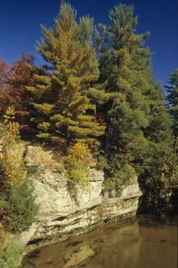
Photo by Thomas A. Meyer/DNR
Located in the Driftless Area of southwestern Wisconsin, Kickapoo Valley Reserve features an extensive landscape with a high diversity of plant communities, numerous rare plants and animals, and significant archeological and geological features. Meandering through the site is the scenic Kickapoo River bordered by numerous sheer cliffs and forested bluffs. The surrounding vegetation is diverse with northern stands of white pine and hemlock, extensive, rich southern hardwood forests dominated by sugar maple and oaks, forested spring seeps, southern sedge meadow, shrub-carr, alder thickets, hardwood swamp, and shaded cliffs.
The shady, sandstone cliffs contain numerous seeps and harbor many rare plants that are restricted to cool, moist microclimates. These cliffs are important habitats for one of Wisconsin's largest populations of a federally threatened plant. Numerous other rare plants are present including a central Wisconsin endemic found nowhere else in the world.
Other communities include oak savanna with an understory of native grasses, robin's plantain, culver's-root, hoary puccoon, and spiderwort; dry prairie remnants with little blue-stem, side-oats grama, pasqueflower, and rough blazing-star; red and white pine relicts; and floodplain forest with silver maple, green ash, and American elm. The Reserve is also home to many rare and uncommon birds.
Restoration and management within many areas will encourage native vegetation and increase the amount of habitat for the rare plants and animals that live within the site. The Kickapoo Valley Reserve is owned by the State of Wisconsin and Bureau of Indian Affairs - in Trust for the Ho-Chunk Nation, and managed by the Kickapoo Reserve Management Board and was designated a State Natural Area in 2002.
Very few State Natural Areas have public facilities, but nearly all are open for a variety of recreational activities as indicated below. Generally, there are no picnic areas, restrooms, or other developments. Parking lots or designated parking areas are noted on individual SNA pages and maps. If a developed trail is present, it will normally be noted on the SNA map and/or under the Maps tab. A compass and topographic map or a GPS unit are useful tools for exploring larger, isolated SNAs.
The good majority of SNAs are isolated and have few or no facilities. Some SNAs have vehicle access lanes or parking lots, but their accessibility may vary depending on weather conditions. Parking lots and lanes are not plowed during winter. Hiking trails may be nonexistent or consist of undeveloped footpaths. A GPS unit or compass and a detailed topographic map are useful tools for exploring larger SNAs.
Non-DNR lands
Entrance fees: For non-DNR-owned SNAs, we are unaware of any vehicle or admission fees. However, please contact the landowner for more information.
Hunting and trapping
Other activities
Other allowable activities such as - but not limited to camping, geocaching and bicycling are determined by the landowner. Please contact them directly or visit their websites for details.
Location
Located between the villages of La Farge and Ontario in Vernon County. 3600 acres.
Driving directions
The two SNA units within the KVR are accessible at multiple points along Highway 131, county highways and township roads. Paddlers can access the Kickapoo River at 20 bridge crossings and landings in the 22.5-mile stretch between Ontario and La Farge. The five-mile-long segment between Landing 5 on Highway 131 downstream to Landing 10 on County Highway P, winds through the hearts of both SNA units. Contact the Kickapoo Valley Reserve Visitor Center in La Farge for access information and maps: S3661 State Highway 131, 608-625-2960. Or visit Kickapoo Valley Reserve [exit DNR] for more information.
The DNR's state natural areas program is comprised of lands owned by the state, private conservation organizations, municipalities, other governmental agencies, educational institutions and private individuals. While the majority of SNAs are open to the public, access may vary according to individual ownership policies. Public use restrictions may apply due to public safety, or to protect endangered or threatened species or unique natural features. Lands may be temporarily closed due to specific management activities.
Users are encouraged to contact the landowner for more specific details. The data shown on these maps have been obtained from various sources, and are of varying age, reliability, and resolution. The data may contain errors or omissions and should not be interpreted as a legal representation of legal ownership boundaries. To create your custom map where you can zoom to a specific location, please use the DNR's Mapping Application.
Kickapoo Valley Reserve is owned by: The Bureau of Indian Affairs and the State of Wisconsin.