Kentuck Lake
No. 442
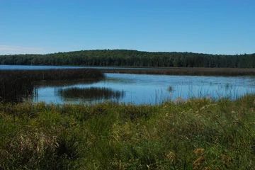
Photo by Josh Mayer
Kentuck Lake features a unique 0.7 miles long, 10-20 meter wide swale flanked by two narrow, curving sandy ridges that parallel the north shore of Kentuck Lake. Wind and wave action, in concert with the lake's size, shape, orientation and basin morphology, have over the centuries created the unique ridge and swale topography found here. The assemblage of plants found on the swale contains representatives of several natural communities seldom found in such close association. Species normally associated with xeric pine forests or barrens exist here intermingled with species characteristic of open bog, conifer swamp, sedge meadow, and calcareous fen. The inland beach consists of a wet, open sandy-peat swale with scattered small trees of tamarack, jack pine, white pine, paper birch, showy mountain ash, red maple, and winter holly.
In open areas are patches of bog species such as sphagnum moss, wire-leaved sedges, and ericaceous shrubs interspersed with patches of bog club moss, sundews, bladderworts, beak-rushes, and sedges. The low ridge adjacent to the lake is densely forested with scattered pines, white spruce, red maple, and balsam fir. To the northeast is a one to two-meter high, 10-30 meters-wide beach ridge forested with an older-growth forest of white and red pine, hemlock, white spruce, black spruce, balsam fir, yellow birch, and white cedar. Further inland is a larger northern wet forest dominated by black spruce and tamarack with small pockets of white cedar, black ash, and red maple.
A dense shrub layer of tag alder, winterberry, and mountain holly is present in the less boggy portions of this wetland. Where a deep carpet of sphagnum moss is present, the shrub layer is composed of ericaceous species including Labrador tea, bog rosemary, and cranberry. Common herbaceous species are cinnamon fern, water arum, and swamp false Solomon's seal. Breeding birds include the Nashville warbler, yellow-rumped warbler, yellow-bellied flycatcher, and white-throated sparrow. Kentuck Lake is owned by the US Forest Service and was designated a State Natural Area in 2007.
Very few State Natural Areas have public facilities, but nearly all are open for a variety of recreational activities as indicated below. Generally, there are no picnic areas, restrooms, or other developments. Parking lots or designated parking areas are noted on individual SNA pages and maps. If a developed trail is present, it will usually be noted on the SNA map and/or under the Maps tab. A compass and topographic map or a GPS unit are useful tools for exploring larger, isolated SNAs.
The good majority of SNAs are isolated and have few or no facilities. Some SNAs have vehicle access lanes or parking lots, but their accessibility may vary depending on weather conditions. Parking lots and lanes are not plowed during winter. Hiking trails may be nonexistent or consist of undeveloped footpaths. A GPS unit or compass and a detailed topographic map are useful tools for exploring larger SNAs.
Non-DNR lands
Entrance fees: For non-DNR-owned SNAs, we are unaware of any vehicle or admission fees. However, please contact the landowner for more information.
Hunting and trapping
Other activities
Other allowable activities such as - but not limited to camping, geocaching and bicycling are determined by the landowner. Please contact them directly or visit their websites for details.
Location
Located within the Chequamegon-Nicolet National Forest. Vilas County. T41N-R12E, Sections 27, 34. 291 acres.
Driving directions
From Eagle River, go east on State Highway 70 for 15 miles, then north on Divide Road for 3 miles to the USFS Kentuck Lake campground. Park and walk on the hiking trail 0.3 miles northwest along the north shore of the lake into the site.
The DNR's state natural areas program is comprised of lands owned by the state, private conservation organizations, municipalities, other governmental agencies, educational institutions and private individuals. While the majority of SNAs are open to the public, access may vary according to individual ownership policies. Public use restrictions may apply due to public safety, or to protect endangered or threatened species or unique natural features. Lands may be temporarily closed due to specific management activities.
Users are encouraged to contact the landowner for more specific details. The data shown on these maps have been obtained from various sources, and are of varying age, reliability, and resolution. The data may contain errors or omissions and should not be interpreted as a legal representation of legal ownership boundaries. To create your custom map where you can zoom to a specific location, please use the DNR's Mapping Application.
Kentuck Lake is owned by: US Forest Service