Kelly Lynn Bog
No. 528
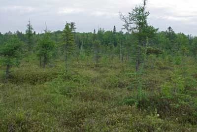
Photo by Thomas A. Meyer/DNR
Kelly Lynn Bog is a large wetland complex comprised of two units with an open bog as the primary feature. Other natural community types are the northern wet forest, the northern sedge meadow, and several shallow, soft-water seepage lakes. Stunted black spruce dominates the bog and in some areas the trees are more densely clustered and form a closed canopy conifer forest. The seepage lakes occur on the southern margin of the area and are surrounded by eskers, kames, and various glacial features. The lake margins support floating bog mats and a great diversity of plant species including a rare orchid. Compared to the west unit, the eastern unit is a more open community. Species composition indicates the flow of mineral water permitting the development of a forested fen. Breeding birds include olive-sided flycatcher, least flycatcher, yellow-throated vireo, Cape May warbler, Canada warbler, mourning warbler, black-and-white warbler, and ovenbird. Kelly Lynn Bog is owned by Langlade County and was designated a State Natural Area in 2006.
Very few State Natural Areas have public facilities, but nearly all are open for a variety of recreational activities as indicated below. Generally, there are no picnic areas, restrooms, or other developments. Parking lots or designated parking areas are noted on individual SNA pages and maps. If a developed trail is present, it will usually be noted on the SNA map and/or under the Maps tab. A compass and topographic map or a GPS unit are useful tools for exploring larger, isolated SNAs.
The good majority of SNAs are isolated and have few or no facilities. Some SNAs have vehicle access lanes or parking lots, but their accessibility may vary depending on weather conditions. Parking lots and lanes are not plowed during winter. Hiking trails may be nonexistent or consist of undeveloped footpaths. A GPS unit or compass and a detailed topographic map are useful tools for exploring larger SNAs.
Non-DNR lands
Entrance fees: For non-DNR-owned SNAs, we are unaware of any vehicle or admission fees. However, please contact the landowner for more information.
Hunting and trapping
Other activities
Other allowable activities such as - but not limited to camping, geocaching and bicycling are determined by the landowner. Please contact them directly or visit their websites for details.
Location
Within the Langlade County Forest, Langlade County. T34N-R9E, Sections 1, 12. T34N-R10E, Sections 5-8. 774 acres.
Driving directions
From the intersection of Highway 45 and Enterprise Lake Road in Elcho, go west on Enterprise Lake Road for 1.4 miles, then west on Moccasin Lake Road for 3.2 miles, then north on Perch Lake Road for 0.8 miles to the junction with Boar's Nest Lane. Bear right on a 2-track lane and continue north 0.6 miles to a culvert crossing separating two large bogs. Park just past the culvert crossing and walk east into the bog. To access the west unit, from Perch Lake Lane continue on Moccasin Lake Road nearly one mile, then go north on an access road of 1.3 miles. Walk north 0.2 miles into the site.
The DNR's state natural areas program is comprised of lands owned by the state, private conservation organizations, municipalities, other governmental agencies, educational institutions and private individuals. While the majority of SNAs are open to the public, access may vary according to individual ownership policies. Public use restrictions may apply due to public safety, or to protect endangered or threatened species or unique natural features. Lands may be temporarily closed due to specific management activities.
Users are encouraged to contact the landowner for more specific details. The data shown on these maps have been obtained from various sources, and are of varying age, reliability, and resolution. The data may contain errors or omissions and should not be interpreted as a legal representation of legal ownership boundaries. To create your custom map where you can zoom to a specific location, please use the DNR's Mapping Application.
Kelly Lynn Bog is owned by: Langlade County