Kangaroo Lake
No. 335
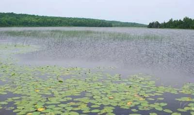
Photo by Thomas A. Meyer/DNR
Kangaroo Lake lies in a basin ½ mile from the Lake Michigan coast and contains a mosaic of communities including a shallow, marl-bottom lake, northern upland forest, northern wet-mesic forest and marsh. While marl lakes are relatively common throughout Door County, undeveloped ones such as Kangaroo Lake are exceptionally rare. The lake's source is the spring-fed Piel Creek, which originates from a series of small springs in an unusual marl fen 5 miles upstream. Piel Creek and the surrounding wetlands provide critical habitat for a rare dragonfly.
This is one of only two known reproducing populations in the country. Lowland forest of white cedar, black ash, tamarack, black spruce, and balsam fir surround the north end of the lake, which is ringed by floating sedge mats. Characteristic shrubs include speckled alder, willows, and meadowsweet. Canada yew, a declining Wisconsin species, is found along a peninsula of the north basin. Common herbs are three-leaved gold-thread, dewberry, naked miterwort, and American starflower. A dolomite plateau with numerous crevices and areas of exposed bedrock contains a forest dominated by sugar maple, beech, white birch, and red oak with a rich diversity of spring wildflowers. Numerous other rare and endangered species are present.
The marsh also provides important breeding and migratory habitats for black terns, sandhill cranes, and many species of waterfowl. A causeway built in the late 1800s separates Kangaroo Lake into two distinct parts - a highly developed southern portion and the northern end, which has almost completely escaped development due to the extensive wetlands. Kangaroo Lake is owned by The Nature Conservancy and the Door County Land Trust and was designated a State Natural Area in 2002.
Very few State Natural Areas have public facilities, but nearly all are open for a variety of recreational activities as indicated below. Generally, there are no picnic areas, restrooms, or other developments. Parking lots or designated parking areas are noted on individual SNA pages and maps. If a developed trail is present, it will usually be noted on the SNA map and/or under the Maps tab. A compass and topographic map or a GPS unit are useful tools for exploring larger, isolated SNAs.
The good majority of SNAs are isolated and have few or no facilities. Some SNAs have vehicle access lanes or parking lots, but their accessibility may vary depending on weather conditions. Parking lots and lanes are not plowed during winter. Hiking trails may be nonexistent or consist of undeveloped footpaths. A GPS unit or compass and a detailed topographic map are useful tools for exploring larger SNAs.
Non-DNR lands
Entrance fees: For non-DNR-owned SNAs, we are unaware of any vehicle or admission fees. However, please contact the landowner for more information.
Hunting and trapping
For hunting opportunities, visit The Nature Conservancy's deer management pages [exit DNR].
Other activities
Other allowable activities such as - but not limited to camping, geocaching and bicycling are determined by the landowner. Please contact them directly or visit their websites for details.
Location
Door County. T30N-R27E, Sections 24, 25. T30N-R28E, Sections 19, 30. 357 acres.
Driving directions
From the junction of Highways 57 and F in Baileys Harbor, go south on 57 for 1.4 miles, then west on County Highway E for 2.4 miles, then north on North Maple Road 100 feet to a parking area and trailhead on the east side of the road. The wetlands are best viewed by canoe. Put in at the west end of the Highway E causeway.
The DNR's state natural areas program comprises lands owned by the state, private conservation organizations, municipalities, other governmental agencies, educational institutions and private individuals. While the majority of SNAs are open to the public, access may vary according to individual ownership policies. Public use restrictions may apply due to public safety, or to protect endangered or threatened species or unique natural features. Lands may be temporarily closed due to specific management activities.
Users are encouraged to contact the landowner for more specific details. The data shown on these maps have been obtained from various sources, and are of varying age, reliability, and resolution. The data may contain errors or omissions and should not be interpreted as a legal representation of legal ownership boundaries. To create your custom map where you can zoom to a specific location, please use the DNR's Mapping Application.
Kangaroo Lake is owned by: The Nature Conservancy and Door County Land Trust