Kamrath Creek Forest and Fen
No. 679
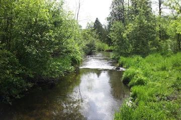
Photo by Jeff Smith
Kamrath Creek Forest and Fen feature small, but high-quality natural communities that are of regional importance. Southern dry-mesic forest occurs on the highest ground and is dominated by red oak and shagbark hickory. Of note is a significant patch of shooting stars about 1/4 acre in size. At the base of the forest slope, water seeps in springs and spring runs from the ground onto moderately sloped semi-open calcareous fen that is sedge-dominated with scattered tamarack and poison sumac.
Many calcium-loving plants (calciphiles) are present including swamp thistle, heart-leaved groundsel, grass-of-Parnassus, and elk sedge. The springs continue further down the slope where the forest canopy becomes more closed and they become forested seeps. The forest is dominated by sugar maple, yellow birch, and basswood with large areas of skunk cabbage, wild ginger, and species of both rich mesic forests and wetlands. Also present is a rich southern mesic forest with sugar maple, basswood, and American beech with a diverse ground layer that includes many spring ephemerals. Kamrath Creek Forest and Fen is owned by the DNR and was designated a State Natural Area in 2016.
Very few State Natural Areas have public facilities, but nearly all are open for a variety of recreational activities as indicated below. Generally, there are no picnic areas, restrooms, or other developments. Parking lots or designated parking areas are noted on individual SNA pages and maps. If a developed trail is present, it will usually be noted on the SNA map and/or under the Maps tab. A compass and topographic map or a GPS unit are useful tools for exploring larger, isolated SNAs.
The good majority of SNAs are isolated and have few or no facilities. Some SNAs have vehicle access lanes or parking lots, but their accessibility may vary depending on weather conditions. Parking lots and lanes are not plowed during winter. Hiking trails may be nonexistent or consist of undeveloped footpaths. A GPS unit or compass and a detailed topographic map are useful tools for exploring larger SNAs.
Entrance fees: Except for Parfrey's Glen, the Cambrian Outlook in the Dells of the Wisconsin River, SNAs within State Parks and some within State Forests, all other DNR-owned SNAs do not have any admission fees. For more information, see Wis. Admin. Code NR 45 [exit DNR]. For non-DNR-owned SNAs, we are unaware of any vehicle or admission fees. However, please contact the landowner for more information.
Allowable activities: DNR-owned land
The activities listed below are generally allowed on all DNR-owned SNA lands. Exceptions to this list of public uses, such as SNAs closed to hunting, are noted above and posted with signs on the property site.
- Hiking
- Fishing
- Cross country skiing
- Hunting
- Trapping
- Scientific research (permit required [PDF])
- Outdoor education
- Wild edibles (What is this?)
- Pets (Rules)
- Wildlife viewing
Prohibited activities: all SNAs
Although some sites allow activities like primitive camping (e.g. Lower Chippewa River on sand bars) or horseback riding (e.g. S. Kettle Moraine), the activities listed below are generally prohibited on DNR-owned SNAs.
- Camping and campfires
- Collecting of animals (other than legally harvested species), non-edible fungi, rocks, minerals, fossils, archaeological artifacts, soil, downed wood, or any other natural material, alive or dead.
- Collecting for scientific research requires a permit issued by the DNR
- Collecting of plants including seeds, roots or other non-edible parts of herbaceous plants such as wildflowers or grasses
- Drones: Flying-related activities, including the use of drones, hang-gliders and model airplanes, are prohibited. Permission may be issued by the SNA Program for the use of drones for educational or research purposes
- Geocaching
- Horseback riding
- Rock climbing
- Vehicles, including bicycles, ATVs, aircraft, and snowmobiles except on trails and roadways designated for their use.
For rules governing state-owned SNAs and other state lands, please consult Chapter NR 45 Wis. Admin. Code [exit DNR].
Location
Within the Onion River Stream Bank Protection Area, Sheboygan County. T15N-R21E, Sections 31, 31. 60 acres.
Driving directions
From the intersection of State Highway 67 and County PP south of Plymouth, go west on 67 for 2.7 miles, then north on ZZ for 0.5 miles to a DNR parking area west of the road.
The DNR's state natural areas program comprises lands owned by the state, private conservation organizations, municipalities, other governmental agencies, educational institutions and private individuals. While the majority of SNAs are open to the public, access may vary according to individual ownership policies. Public use restrictions may apply due to public safety, or to protect endangered or threatened species or unique natural features. Lands may be temporarily closed due to specific management activities.
Users are encouraged to contact the landowner for more specific details. The data shown on these maps have been obtained from various sources, and are of varying age, reliability, and resolution. The data may contain errors or omissions and should not be interpreted as a legal representation of legal ownership boundaries. To create your custom map where you can zoom to a specific location, please use the DNR's Mapping Application.
Kamrath Creek Forest and Fen is owned by: Wisconsin DNR
Management objectives and prescriptions
- Read the Northern Kettle Moraine Region Master Plan for details.