Jump River Woods
No. 552
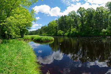
Photo by Josh Mayer
Situated along the Jump River is a floodplain forest of black ash and American elm with yellow birch, basswood, ironwood, and bur oak. This area is frequently disturbed by the scouring of the quickly rising and falling Jump River. The understory contains many prairie species including prairie cordgrass, fowl manna grass, prairie alumroot, and tall meadowrue. Bur oak dominates on the terraces above the floodplain with red maple and basswood. The understory is a combination of very rich northern hardwood forest and oak savanna species, a combination that is unknown elsewhere in Wisconsin.
Plants include blue cohosh, nodding trillium, bloodroot, Canada mayflower, bottlebrush grass, wild sarsaparilla, zig-zag goldenrod, and wood thistle. Also, the present is a small patch of sugar maple, yellow birch, and basswood forest with abundant hemlock and scattered super canopy white pines. This stand is important in that it is at the threshold for attaining old-growth characteristics. The characteristic ground flora includes wild sarsaparilla, mountain wood-sorrel, yellow blue bead lily, red baneberry, shinleaf, Canada bunchberry, and three-leaved goldthread Jump River Woods is owned by Price County and was designated a State Natural Area in 2007.
Very few State Natural Areas have public facilities, but nearly all are open for a variety of recreational activities as indicated below. Generally, there are no picnic areas, restrooms, or other developments. Parking lots or designated parking areas are noted on individual SNA pages and maps. If a developed trail is present, it will usually be noted on the SNA map and/or under the Maps tab. A compass and topographic map or a GPS unit are useful tools for exploring larger, isolated SNAs.
The good majority of SNAs are isolated and have few or no facilities. Some SNAs have vehicle access lanes or parking lots, but their accessibility may vary depending on weather conditions. Parking lots and lanes are not plowed during winter. Hiking trails may be nonexistent or consist of undeveloped footpaths. A GPS unit or compass and a detailed topographic map are useful tools for exploring larger SNAs.
Non-DNR lands
Entrance fees: For non-DNR-owned SNAs, we are unaware of any vehicle or admission fees. However, please contact the landowner for more information.
Hunting and trapping
Other activities
Other allowable activities such as - but not limited to camping, geocaching and bicycling are determined by the landowner. Please contact them directly or visit their websites for details.
Location
Within the Price County Forest, Price County. T34N-R2W, Sections 19, 20, 29, 30. 221 acres.
Driving directions
From the intersection of Highway 73 and D in Jump River, go east on County D for 6.5 miles, then north on Forest Road 1523 for 2.2 miles, then continue north on Wolf Creek Road for 3.3 miles. Go northwest on an access road of 1.2 miles. Walk northwest toward the site toward the river.
The DNR's state natural areas comprise lands owned by the state, private conservation organizations, municipalities, other governmental agencies, educational institutions and private individuals. While the majority of SNAs are open to the public, access may vary according to individual ownership policies. Public use restrictions may apply due to public safety, or to protect endangered or threatened species or unique natural features. Lands may be temporarily closed due to specific management activities.
Users are encouraged to contact the landowner for more specific details. The data shown on these maps have been obtained from various sources, and are of varying age, reliability, and resolution. The data may contain errors or omissions and should not be interpreted as a legal representation of legal ownership boundaries. To create your custom map where you can zoom to a specific location, please use the DNR's Mapping Application.
Jump River Woods is owned by: Price County