Johnson Lake Barrens and Springs
No. 107
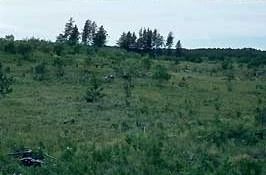
Photo by E. Epstein
Johnson Lake Barrens and Springs contains open communities of pine barrens and bracken grassland perched on the sandy glacial outwash plain that gently slopes toward the lake. Dominant trees are scattered, open-grown jack pine, Hill's oak, red pine and choke cherry. The ground layer is dominated by sweet fern, blueberry, barren strawberry, rice grass, poverty oat grass, hawkweed and arrow-leaved aster. The moister west and north slopes have a large number of aspen and openings nearly covered with bracken fern. Water resources include Johnson Lake, a soft-water spring complex, and three cold, hard water streams that meander through the site: Garland, Siphon, and Johnson Creeks. The 24-acre Johnson Lake is a soft-water drainage lake fed by Garland Creek. Abundant submerged aquatics are present including white water lily, spatterdock, big-leaf pondweed, floating pondweed, flat-stem pondweed and common water-weed. A northern sedge meadow dominated by wire-leaved sedges surrounds the lake and seepage areas at the base of the terrace contain black spruce and tamarack. Formed in pitted outwash and moraine at the Manitowish River headwaters is the Siphon Springs complex, which includes Goodyear Springs, a 3-acre spring pond with a maximum depth of 8 feet. Water is neutral in pH, 52 ppm total alkalinity, and supports brook trout, white sucker, common minnow species, and sparse growth of aquatic plants including water shield, chara, wild celery and waterweed. The spring and outlet are filled partially with silt but retain deep pockets of exposed sand and gravel. The area has a wide range of animal life including hermit thrush, Connecticut warbler, common yellow-throat, swamp sparrow, Lincoln's sparrow, spruce grouse and bobcat. Restoration management activities have included prescribed burning and the cutting of aspen and small jack pine, which has opened up the area. Johnson Lake Barrens and Springs is owned by the DNR and was designated a State Natural Area in 1973. The boundary was expanded in 2007 to include the spring pond complex.
Very few State Natural Areas have public facilities, but nearly all are open for a variety of recreational activities as indicated below. Generally, there are no picnic areas, restrooms, or other developments. Parking lots or designated parking areas are noted on individual SNA pages and maps. If a developed trail is present, it will usually be noted on the SNA map and/or under the Maps tab. A compass and topographic map or a GPS unit are useful tools for exploring larger, isolated SNAs.
The good majority of SNAs are isolated and have few or no facilities. Some SNAs have vehicle access lanes or parking lots, but their accessibility may vary depending on weather conditions. Parking lots and lanes are not plowed during winter. Hiking trails may be nonexistent or consist of undeveloped footpaths. A GPS unit or compass and a detailed topographic map are useful tools for exploring larger SNAs.
Entrance fees: Except for Parfrey's Glen, the Cambrian Outlook in the Dells of the Wisconsin River, SNAs within State Parks and some within State Forests, all other DNR-owned SNAs do not have any admission fees. For more information, see Wis. Admin. Code NR 45 [exit DNR]. For non-DNR-owned SNAs, we are unaware of any vehicle or admission fees. However, please contact the landowner for more information.
Allowable activities: DNR-owned land
The activities listed below are generally allowed on all DNR-owned SNA lands. Exceptions to this list of public uses, such as SNAs closed to hunting, are noted above and posted with signs on the property site.
- Hiking
- Fishing
- Cross country skiing
- Hunting
- Trapping
- Scientific research (permit required [PDF])
- Outdoor education
- Wild edibles (What is this?)
- Pets (Rules)
- Wildlife viewing
Prohibited activities: all SNAs
Although some sites allow activities like primitive camping (e.g. Lower Chippewa River on sand bars) or horseback riding (e.g. S. Kettle Moraine), the activities listed below are generally prohibited on DNR-owned SNAs.
- Camping and campfires
- Collecting of animals (other than legally harvested species), non-edible fungi, rocks, minerals, fossils, archaeological artifacts, soil, downed wood, or any other natural material, alive or dead.
- Collecting for scientific research requires a permit issued by the DNR
- Collecting of plants including seeds, roots or other non-edible parts of herbaceous plants such as wildflowers or grasses
- Drones: Flying-related activities, including the use of drones, hang-gliders and model airplanes, are prohibited. Permission may be issued by the SNA Program for the use of drones for educational or research purposes
- Geocaching
- Horseback riding
- Rock climbing
- Vehicles, including bicycles, ATVs, aircraft, and snowmobiles except on trails and roadways designated for their use.
For rules governing state-owned SNAs and other state lands, please consult Chapter NR 45 Wis. Admin. Code [exit DNR].
Location
Within the Northern Highland-American Legion State Forest, Vilas County. T42N-R8E, Sections 2, 3, 4, 8-11, 13-16. 1,130 acres.
Driving directions
From the intersection of County Highways B and M (Cut-off Road) north of Boulder Junction, go east on County B for 4.5 miles, then south on Old B for 1.9 miles, then west on Jute Lake Road for 1.4 miles, then south on logging roads to the natural area.
The DNR's state natural areas program comprises lands owned by the state, private conservation organizations, municipalities, other governmental agencies, educational institutions and private individuals. While the majority of SNAs are open to the public, access may vary according to individual ownership policies. Public use restrictions may apply due to public safety, or to protect endangered or threatened species or unique natural features. Lands may be temporarily closed due to specific management activities.
Users are encouraged to contact the landowner for more specific details. The data shown on these maps have been obtained from various sources, and are of varying age, reliability, and resolution. The data may contain errors or omissions and should not be interpreted as a legal representation of legal ownership boundaries. To create your custom map where you can zoom to a specific location, please use the DNR's Mapping Application.
Johnson Lake Barrens and Springs is owned by: Wisconsin DNR