Johnson Falls
No. 557
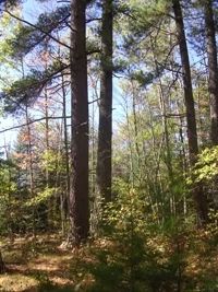
Photo by Patrick Robinson
Located on sandy outwash, Johnson Falls is located along both sides of a 1.5-mile section of the Peshtigo River. Here the river flows through a narrow, rocky to sandy-bottomed valley with steep slopes and gently rolling sandy plains above the valley. Below the Johnson Falls Dam are mature forests situated on steep, sandy slopes and old river terraces. Mature dry-mesic pine and oak forest and a white cedar-dominated wet-mesic forest are the dominant features. The wet-mesic forest contains some cedars exceeding 15 inches in diameter.
Common canopy associates are balsam fir, and black spruce with paper birch, white spruce, basswood, white pine, black ash, hemlock, and red maple. The ground layer is diverse and contains species such as three-leaved goldthread, orange jewelweed, naked miterwort, dwarf red raspberry, wild sarsaparilla, American spurred-gentian, and various sedges. Sphagnum mosses form an extensive carpet in some parts of the stands. Seeps and spring runs occur at the slope base and these areas support dense masses of bulblet bladder fern, golden ragwort, cinnamon fern, and common oak fern. The sandy uplands contain some areas of high-quality white and red pine forests and more open areas support a rare plant that is found in pine forests on sterile sand and gravel outwash plains.
Also present is a granitic bedrock outcrop with a relatively undisturbed glade and dry cliff community on the slopes and uplands on the northeast side of the river. Hill's oak, with red maple, white oaks, white pine and jack pine are the primary trees present. The sparse shrub layer is comprised of hazelnut and early low blueberry while the ground flora contains poverty oat grass, Pennsylvania sedge, big bluestem, and little bluestem. Lichens and mosses are common on exposed bedrock and thin soil. Johnson Falls is owned by the DNR and was designated a State Natural Area in 2007.
Very few State Natural Areas have public facilities, but nearly all are open for a variety of recreational activities as indicated below. Generally, there are no picnic areas, restrooms, or other developments. Parking lots or designated parking areas are noted on individual SNA pages and maps. If a developed trail is present, it will usually be noted on the SNA map and/or under the Maps tab. A compass and topographic map or a GPS unit are useful tools for exploring larger, isolated SNAs.
The good majority of SNAs are isolated and have few or no facilities. Some SNAs have vehicle access lanes or parking lots, but their accessibility may vary depending on weather conditions. Parking lots and lanes are not plowed during winter. Hiking trails may be nonexistent or consist of undeveloped footpaths. A GPS unit or compass and a detailed topographic map are useful tools for exploring larger SNAs.
Entrance fees: Except for Parfrey's Glen, the Cambrian Outlook in the Dells of the Wisconsin River, SNAs within State Parks and some within State Forests, all other DNR-owned SNAs do not have any admission fees. For more information, see Wis. Admin. Code NR 45 [exit DNR]. For non-DNR-owned SNAs, we are unaware of any vehicle or admission fees. However, please contact the landowner for more information.
Allowable activities: DNR-owned land
The activities listed below are generally allowed on all DNR-owned SNA lands. Exceptions to this list of public uses, such as SNAs closed to hunting, are noted above and posted with signs on the property site.
- Hiking
- Fishing
- Cross country skiing
- Hunting
- Trapping
- Scientific research (permit required [PDF])
- Outdoor education
- Wild edibles (What is this?)
- Pets (Rules)
- Wildlife viewing
Prohibited activities: all SNAs
Although some sites allow activities like primitive camping (e.g. Lower Chippewa River on sand bars) or horseback riding (e.g. S. Kettle Moraine), the activities listed below are generally prohibited on DNR-owned SNAs.
- Camping and campfires
- Collecting of animals (other than legally harvested species), non-edible fungi, rocks, minerals, fossils, archaeological artifacts, soil, downed wood, or any other natural material, alive or dead.
- Collecting for scientific research requires a permit issued by the DNR
- Collecting of plants including seeds, roots or other non-edible parts of herbaceous plants such as wildflowers or grasses
- Drones: Flying-related activities, including the use of drones, hang-gliders and model airplanes, are prohibited. Permission may be issued by the SNA Program for the use of drones for educational or research purposes
- Geocaching
- Horseback riding
- Rock climbing
- Vehicles, including bicycles, ATVs, aircraft, and snowmobiles except on trails and roadways designated for their use.
For rules governing state-owned SNAs and other state lands, please consult Chapter NR 45 Wis. Admin. Code [exit DNR].
Location
Within the Peshtigo River State Forest, Marinette County. T32N-R19E, Sections 4, 5. T33N-R19E, Sections 33, 34. 210 acres.
Driving directions
From the intersection of County Highway A and W in Crivitz, go north and west on County A for 6.1 miles, then east and north on Newton Lake Road for 1.8 miles, then west on High Falls Road for 1.9 miles. The site is located on both sides of a 1.5-mile section of the Peshtigo River below the Johnson Falls Dam.
The DNR's state natural areas program comprises lands owned by the state, private conservation organizations, municipalities, other governmental agencies, educational institutions and private individuals. While the majority of SNAs are open to the public, access may vary according to individual ownership policies. Public use restrictions may apply due to public safety, or to protect endangered or threatened species or unique natural features. Lands may be temporarily closed due to specific management activities.
Users are encouraged to contact the landowner for more specific details. The data shown on these maps have been obtained from various sources, and are of varying age, reliability, and resolution. The data may contain errors or omissions and should not be interpreted as a legal representation of legal ownership boundaries. To create your custom map where you can zoom to a specific location, please use the DNR's Mapping Application.
Johnson Falls is owned by: Wisconsin DNR