Island Lake Hemlocks
No. 595
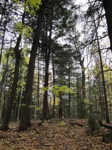
Photo by Wisconsin DNR
Island Lake Hemlocks features one of the oldest and most intact old-growth hemlock-hardwood stands in northern Wisconsin. They are extremely rare in today's landscape. This site still contains many large trees including a 10-acre upland island of undisturbed, old-growth hemlock and yellow birch with some trees reaching 30 inches in diameter. The "island" is situated within an extensive conifer-shrub swamp. Hemlock dominates the canopy with yellow birch and white cedar as the major canopy associates. Scattered throughout the site are kettle depressions containing small stands of swamp hardwood and mixed conifer swamp.
Hemlock regeneration is notable along the edges of some of these wetter areas. Balsam fir is common in canopy gaps as saplings and small trees, but mixed thickets of hemlock-fir saplings occur on the western and southern edges. An open bog/muskeg is present within the site's interior and small ephemeral ponds are found in areas with a perched water table. Resident bird species include the blackburnian warbler, black-throated green warbler, chimney swift, pileated woodpecker, and golden-crowned kinglet. Island Lake Hemlocks and the surrounding area is also critical habitat for a state-endangered species that have a breeding population in the central part of Iron County. This animal prefers older aged mixed hardwoods and hemlock/pine.
This site, with its 250-plus-year-old hemlock, provides some of the best habitats in the area. Protection of this site and other core habitat parcels throughout this area is critical for the continued existence of this population. Island Lake Hemlocks is owned by the DNR and was designated a State Natural Area in 2009.
Very few State Natural Areas have public facilities, but nearly all are open for a variety of recreational activities as indicated below. Generally, there are no picnic areas, restrooms, or other developments. Parking lots or designated parking areas are noted on individual SNA pages and maps. If a developed trail is present, it will normally be noted on the SNA map and/or under the Maps tab. A compass and topographic map or a GPS unit are useful tools for exploring larger, isolated SNAs.
The good majority of SNAs are isolated and have few or no facilities. Some SNAs have vehicle access lanes or parking lots, but their accessibility may vary depending on weather conditions. Parking lots and lanes are not plowed during winter. Hiking trails may be nonexistent or consist of undeveloped footpaths. A GPS unit or compass and a detailed topographic map are useful tools for exploring larger SNAs.
Entrance fees: Except for Parfrey's Glen, the Cambrian Outlook in the Dells of the Wisconsin River, SNAs within State Parks and some within State Forests, all other DNR-owned SNAs do not have any admission fees. For more information, see Wis. Admin. Code NR 45 [exit DNR]. For non-DNR-owned SNAs, we are unaware of any vehicle or admission fees. However, please contact the landowner for more information.
Allowable activities: DNR-owned land
The activities listed below are generally allowed on all DNR-owned SNA lands. Exceptions to this list of public uses, such as SNAs closed to hunting, are noted above and posted with signs on the property site.
- Hiking
- Fishing
- Cross country skiing
- Hunting
- Trapping
- Scientific research (permit required [PDF])
- Outdoor education
- Wild edibles (What is this?)
- Pets (Rules)
- Wildlife viewing
Prohibited activities: all SNAs
Although a handful of sites allow activities like primitive camping (e.g. Lower Chippewa River on sand bars) or horseback riding (e.g. S. Kettle Moraine), the activities listed below are generally prohibited on DNR-owned SNAs.
- Camping and campfires
- Collecting of animals (other than legally harvested species), non-edible fungi, rocks, minerals, fossils, archaeological artifacts, soil, downed wood, or any other natural material, alive or dead.
- Collecting for scientific research requires a permit issued by the DNR
- Collecting of plants including seeds, roots or other non-edible parts of herbaceous plants such as wildflowers or grasses
- Drones: Flying-related activities, including the use of drones, hang-gliders and model airplanes, are prohibited. Permission may be issued by the SNA Program for the use of drones for educational or research purposes
- Geocaching
- Horseback riding
- Rock climbing
- Vehicles, including bicycles, ATVs, aircraft, and snowmobiles except on trails and roadways designated for their use.
For rules governing state-owned SNAs and other state lands, please consult Chapter NR 45 Wis. Admin. Code [exit DNR].
Location
Iron County. T44N-R1E, Sections 13, 24. 120 acres.
Driving directions
From the intersection of County J and Highway 51 in Mercer, go north on 51 for 8.5 miles, then follow Island Lake Road west and north about 12 miles to a forest logging road. Go east 0.12 miles and take the right fork to its end. Walk south into the natural area. The best hemlocks are found in the northeast corner of the site.
The DNR's state natural areas program is comprised of lands owned by the state, private conservation organizations, municipalities, other governmental agencies, educational institutions and private individuals. While the majority of SNAs are open to the public, access may vary according to individual ownership policies. Public use restrictions may apply due to public safety, or to protect endangered or threatened species or unique natural features. Lands may be temporarily closed due to specific management activities.
Users are encouraged to contact the landowner for more specific details. The data shown on these maps have been obtained from various sources, and are of varying age, reliability, and resolution. The data may contain errors or omissions and should not be interpreted as a legal representation of legal ownership boundaries. To create your custom map where you can zoom to a specific location, please use the DNR's Mapping Application.
Island Lake Hemlocks is owned by: Wisconsin DNR