Inch Lake
No. 499
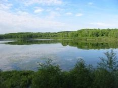
Photo by Mark Martin
Inch Lake SNA features two undeveloped lakes surrounded by wetlands and rolling upland forests. The property abuts the Chequamegon-Nicolet National Forest to the south. Inch Lake is a 31-acre undeveloped, soft-water seepage lake containing largemouth bass, yellow perch, and panfish. The 41-foot deep lake is classified as a "wild lake", an increasingly uncommon feature as development pressure intensifies in northern Wisconsin. No motors are allowed and only artificial lures may be used.
These special regulations will provide important research opportunities related to fishing. Surrounding the southern portion of Inch Lake is a diverse northern mesic forest dominated by red pine, red oak, and aspen. Canopy associates include white spruce, white pine, and paper birch. The shrub layer contains abundant American hazelnut and sugar maple saplings. Understory species include Indian pipe, sweet fern, interrupted fern, and blueberries. North of the lake is a northern dry-mesic forest dominated by large red pine and red oak with a diverse ground flora. Species include bracken fern, wood betony, big-leaved aster, thimbleberry, American starflower, and wild sarsaparilla.
The site also features scattered wetland depressions vegetated with wool grass, leather leaf, and sphagnum moss. Hildur Lake is a 66-acre hard-water drainage lake on the lower end of the Pike Lake chain. The lake and associated spring pond are the headwaters of the White River. The lake bottom is primarily gravel with a few scattered areas of sand and muck. Fish include northern pike, largemouth bass, muskie, yellow perch, bluegill, and crappie. Surrounding the lake is a narrow band of leatherleaf and alder with uplands comprised of mixed northern hardwoods. Rolling topography to the east supports a northern dry-mesic forest dominated by red pine with red oak and sugar maple.
In addition, this area contains a diversity of other natural community types including a small wetland that supports nesting common loons. Bald eagles also occur here. Inch Lake was donated to the DNR by Jill and Jerry Martin – their second donated State Natural Area property. In 2007, the adjacent Hildur Lake parcel was acquired by Landmark Conservancy and later donated to the DNR for incorporation into the State Natural Area Program. The acquisition was assisted by a partial donation from the Harris family. Inch Lake was designated a State Natural Area in 2006.
Very few State Natural Areas have public facilities, but nearly all are open for a variety of recreational activities as indicated below. Generally, there are no picnic areas, restrooms, or other developments. Parking lots or designated parking areas are noted on individual SNA pages and maps. If a developed trail is present, it will normally be noted on the SNA map and/or under the Maps tab. A compass and topographic map or a GPS unit are useful tools for exploring larger, isolated SNAs.
The good majority of SNAs are isolated and have few or no facilities. Some SNAs have vehicle access lanes or parking lots, but their accessibility may vary depending on weather conditions. Parking lots and lanes are not plowed during winter. Hiking trails may be nonexistent or consist of undeveloped footpaths. A GPS unit or compass and a detailed topographic map are useful tools for exploring larger SNAs.
Entrance fees: Except for Parfrey's Glen, the Cambrian Outlook in the Dells of the Wisconsin River, SNAs within State Parks and some within State Forests, all other DNR-owned SNAs do not have any admission fees. For more information, see Wis. Admin. Code NR 45 [exit DNR]. For non-DNR-owned SNAs, we are unaware of any vehicle or admission fees. However, please contact the landowner for more information.
Special Regulations apply to Inch Lake: Inch Lake is catch-and-release only. No use of live bait is permitted. Motors, including electric, are not permitted.
Allowable activities: DNR-owned land
The activities listed below are generally allowed on all DNR-owned SNA lands. Exceptions to this list of public uses, such as SNAs closed to hunting, are noted above and posted with signs on the property site.
- Hiking
- Fishing
- Cross country skiing
- Hunting
- Trapping
- Scientific research (permit required [PDF])
- Outdoor education
- Wild edibles (What is this?)
- Pets (Rules)
- Wildlife viewing
Prohibited activities: all SNAs
Although a handful of sites allow activities like primitive camping (e.g. Lower Chippewa River on sand bars) or horseback riding (e.g. S. Kettle Moraine), the activities listed below are generally prohibited on DNR-owned SNAs.
- Camping and campfires
- Collecting of animals (other than legally harvested species), non-edible fungi, rocks, minerals, fossils, archaeological artifacts, soil, downed wood, or any other natural material, alive or dead.
- Collecting for scientific research requires a permit issued by the DNR
- Collecting of plants including seeds, roots or other non-edible parts of herbaceous plants such as wildflowers or grasses
- Drones: Flying-related activities, including the use of drones, hang-gliders and model airplanes, are prohibited. Permission may be issued by the SNA Program for the use of drones for educational or research purposes
- Geocaching
- Horseback riding
- Rock climbing
- Vehicles, including bicycles, ATVs, aircraft, and snowmobiles except on trails and roadways designated for their use.
For rules governing state-owned SNAs and other state lands, please consult Chapter NR 45 Wis. Admin. Code [exit DNR].
Location
Bayfield County. T46N-R8W, 2, 3, 11; T47N-R8W, Sections 34, 35. 626 acres.
Driving directions
From the intersection of US Highway 2 and County H in Iron River, go south on H 6.6 miles to Scenic Drive, then south 0.9 miles to a parking area east of the road. A lane leads northeast to the lake and affords carry-in canoe/kayak access. Another small parking area is located 0.5 miles southeast of Scenic Drive off County H.
The DNR's state natural areas program is comprised of lands owned by the state, private conservation organizations, municipalities, other governmental agencies, educational institutions and private individuals. While the majority of SNAs are open to the public, access may vary according to individual ownership policies. Public use restrictions may apply due to public safety, or to protect endangered or threatened species or unique natural features. Lands may be temporarily closed due to specific management activities.
Users are encouraged to contact the landowner for more specific details. The data shown on these maps have been obtained from various sources, and are of varying age, reliability, and resolution. The data may contain errors or omissions and should not be interpreted as a legal representation of legal ownership boundaries. To create your custom map where you can zoom to a specific location, please use the DNR's Mapping Application.
Inch Lake is owned by: Wisconsin DNR