Hulburt Creek Woods
No. 371
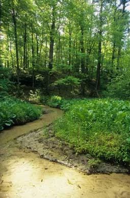
Photo by Thomas A. Meyer/DNR
Hulburt Creek Woods, comprised of three separate units, contains a rich and diverse complex of communities along a small Class I trout stream in the Driftless Area of Wisconsin. Hulbert Creek is a clear, cold, fast-flowing stream with numerous springs, many originating from under the sandstone outcrops. Impressive sandstone cliffs with northern and southern dry-mesic forest relics, bedrock exposures, and shaded cliffs are also present. The forest relicts, inaccessible due to their location on steep bluffs and valley slopes, were protected through time from development and logging.
The southern dry-mesic forest is dominated by black, white, and red oaks with associated trees of shagbark, bitternut hickory, jack pine, red maple, white birch, aspen, and black cherry. Blackberries dominate the shrub layer with sumac along the edges and openings. White pine dominates the northern dry-mesic forest; however, there are substantial quantities of red maple, red pine and red oak. Common understory plants include trailing arbutus, large-leaved aster, oak fern, American starflower, Canada mayflower, and small enchanter's nightshade. Impressive sandstone cliffs characteristic of the Driftless Area contains numerous seeps and cold air drainages where plants with more northern affinities occur. Species include the uncommon Sullivant's cool-wort, common polypody fern, fragile and bulblet fern, maidenhair fern, partridgeberry, prairie alumroot and many liverworts and mosses.
The cliffs also provide nesting habitat for many cliff swallows. Along the creek and its tributaries is a well-developed alder thicket. The cool water and shaded banks provide a habitat for some specialized cold water plants, including American golden saxifrage, marsh pennywort, water-starwort, and marsh purslane. Hulburt Creek Woods is owned by the DNR and was designated a State Natural Area in 2002.
Very few State Natural Areas have public facilities, but nearly all are open for a variety of recreational activities as indicated below. Generally, there are no picnic areas, restrooms, or other developments. Parking lots or designated parking areas are noted on individual SNA pages and maps. If a developed trail is present, it will normally be noted on the SNA map and/or under the Maps tab. A compass, topographic map, or GPS unit are useful tools for exploring larger, isolated SNAs.
The good majority of SNAs are isolated and have few or no facilities. Some SNAs have vehicle access lanes or parking lots, but their accessibility may vary depending on weather conditions. Parking lots and lanes are not plowed during winter. Hiking trails may be nonexistent or consist of undeveloped footpaths. A GPS unit or compass and a detailed topographic map are valuable for exploring larger SNAs.
Entrance fees: Except for Parfrey's Glen, the Cambrian Outlook in the Dells of the Wisconsin River, SNAs within State Parks and some within State Forests, all other DNR-owned SNAs do not have any admission fees. For more information, see Wis. Admin. Code NR 45 [exit DNR]. For non-DNR-owned SNAs, we are unaware of any vehicle or admission fees. However, please contact the landowner for more information.
Allowable activities: DNR-owned land
The activities listed below are generally allowed on all DNR-owned SNA lands. Exceptions to this list of public uses, such as SNAs closed to hunting, are noted above and posted with signs on the property site.
- Hiking
- Fishing
- Cross country skiing
- Hunting
- Trapping
- Scientific research (permit required [PDF])
- Outdoor education
- Wild edibles (What is this?)
- Pets (Rules)
- Wildlife viewing
Prohibited activities: all SNAs
Although a handful of sites allow activities like primitive camping (e.g. Lower Chippewa River on sand bars) or horseback riding (e.g. S. Kettle Moraine), the activities listed below are generally prohibited on DNR-owned SNAs.
- Camping and campfires
- Collecting of animals (other than legally harvested species), non-edible fungi, rocks, minerals, fossils, archaeological artifacts, soil, downed wood, or any other natural material, alive or dead.
- Collecting for scientific research requires a permit issued by the DNR
- Collecting of plants including seeds, roots or other non-edible parts of herbaceous plants such as wildflowers or grasses
- Drones: Flying-related activities, including the use of drones, hang-gliders and model airplanes, are prohibited. Permission may be issued by the SNA Program for the use of drones for educational or research purposes
- Geocaching
- Horseback riding
- Rock climbing
- Vehicles, including bicycles, ATVs, aircraft, and snowmobiles except on trails and roadways designated for their use.
For rules governing state-owned SNAs and other state lands, please consult Chapter NR 45 Wis. Admin. Code [exit DNR].
Location
Within Hulburt Creek Fishery Area, Sauk County. T13N-R5E, Section 1. T13N-R6E, Section 5, 6. 166 acres.
Driving directions
From the intersection of County H and Old Highway 12, just west of the I-90/Highway 13 exit, go northwest on Old Highway 12 for 1.2 miles, then continue west on Lage Road for approximately one mile and park. Follow the creek southeast into the natural area. Or continue west 0.4 miles and walk south into the natural area.
The DNR's state natural areas program is comprised of lands owned by the state, private conservation organizations, municipalities, other governmental agencies, educational institutions, and private individuals. While the majority of SNAs are open to the public, access may vary according to individual ownership policies. Public use restrictions may apply due to public safety, or to protect endangered or threatened species or unique natural features. Lands may be temporarily closed due to specific management activities.
Users are encouraged to contact the landowner for more specific details. The data shown on these maps have been obtained from various sources, and are of varying age, reliability, and resolution. The data may contain errors or omissions and should not be interpreted as a legal representation of legal ownership boundaries. To create your custom map where you can zoom to a specific location, please use the DNR's Mapping Application.
Hulburt Creek Woods is owned by: Wisconsin DNR