Hub City Bog
No. 80
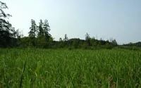
Photo by Craig Anderson
Hub City Bog features an unusual tamarack bog island and tall shrub community with pine/hemlock relicts and associated shaded cliffs also present. This uncommon Driftless Area bog was formed in an oxbow lake left by the meandering Pine River. To the east of the bog is Soules Creek which flows at the base of a 75-foot sandstone cliff. The north north-facing on UW property supports a northern forest of hemlock, white pine, and yellow birch with a ground cover of Labrador tea, trailing arbutus, bunchberry, wintergreen, and Sullivant's cool-wort.
The project area was expanded in 2007 to include more of the remaining unique pine/hemlock relics found in this area. Only a small portion of the relicts are currently protected by the DNR. The tamaracks in the bog have suffered nearly 70 percent mortality due to an infestation of larch bark beetle. However, some tamarack reproduction is taking place. Many springs are present in the tamarack swamp. Most typical bog plants are absent, although sphagnum moss and some very showy species are found. Hub City Bog is owned by the DNR and UW Board of Regents. It was designated a State Natural Area in 1970.
Very few State Natural Areas have public facilities, but nearly all are open for a variety of recreational activities as indicated below. Generally, there are no picnic areas, restrooms, or other developments. Parking lots or designated parking areas are noted on individual SNA pages and maps. If a developed trail is present, it will normally be noted on the SNA map and/or under the Maps tab. A compass, topographic map, or GPS unit are useful tools for exploring larger, isolated SNAs.
The good majority of SNAs are isolated and have few or no facilities. Some SNAs have vehicle access lanes or parking lots, but their accessibility may vary depending on weather conditions. Parking lots and lanes are not plowed during winter. Hiking trails may be nonexistent or consist of undeveloped footpaths. A GPS unit or compass and a detailed topographic map are valuable tools for exploring larger SNAs.
Hunting and trapping
Allowable activities: DNR-owned land
The activities listed below are generally allowed on all DNR-owned SNA lands. Exceptions to this list of public uses, such as SNAs closed to hunting, are noted above and posted with signs on the property site.
- Hiking
- Fishing
- Cross country skiing
- Hunting
- Trapping
- Scientific research (permit required [PDF])
- Outdoor education
- Wild edibles (What is this?)
- Pets (Rules)
- Wildlife viewing
Prohibited activities: all SNAs
- Camping and campfires
- Collecting of animals (other than legally harvested species), non-edible fungi, rocks, minerals, fossils, archaeological artifacts, soil, downed wood, or any other natural material, alive or dead.
- Collecting for scientific research requires a permit issued by the DNR
- Collecting of plants including seeds, roots or other non-edible parts of herbaceous plants such as wildflowers or grasses
- Geocaching
- Horseback riding
- Rock climbing
- Vehicles, including bicycles, ATVs, aircraft, and snowmobiles except on trails and roadways designated for their use.
For rules governing state-owned SNAs and other state lands, please consult Chapter NR 45 Wis. Admin. Code [exit DNR].
Location
Richland County. T11N-R1E, Section 3. T12N-R1E, Section 34. 107 acres.
Driving directions
To access the DNR-owned property: From Hub City, go south on Highway 80 for 0.5 miles, then east on County I for 0.25 miles. Please contact the University of Wisconsin-Madison Arboretum at 608-263-7344 for permission to access their property.
The DNR's state natural areas program is comprised of lands owned by the state, private conservation organizations, municipalities, other governmental agencies, educational institutions and private individuals. While the majority of SNAs are open to the public, access may vary according to individual ownership policies. Public use restrictions may apply due to public safety, or to protect endangered or threatened species or unique natural features. Lands may be temporarily closed due to specific management activities.
Users are encouraged to contact the landowner for more specific details. The data shown on these maps have been obtained from various sources, and are of varying age, reliability, and resolution. The data may contain errors or omissions and should not be interpreted as a legal representation of legal ownership boundaries. To create your custom map where you can zoom to a specific location, please use the DNR's Mapping Application.
Hub City Bog is owned by: The UW Board of Regents and the Wisconsin DNR