Hortonville Bog
No. 214
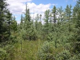
Photo by Andy Clark
Hortonville Bog is one of the best bogs in southern Wisconsin and contains an open ericaceous bog with a very deep sphagnum layer. Dominants are leather-leaf and Labrador-tea. Poison sumac is abundant throughout the site. Although there is no open water, the bog is very spongy. Surrounding the bog is an advancing ring of tamarack and black spruce in all age and size classes. To the south is a wet-mesic forest dominated by tamarack and white cedar. The bog contains several species of birds indicative of northern bog communities: winter wren, Canada warbler, Nashville warbler, white-throated sparrow, sharp-shinned hawk, northern waterthrush, and Lincoln's sparrow. Hortonville Bog is owned by the DNR and was designated a State Natural Area in 1987.
Very few State Natural Areas have public facilities, but nearly all are open for a variety of recreational activities as indicated below. Generally, there are no picnic areas, restrooms, or other developments. Parking lots or designated parking areas are noted on individual SNA pages and maps. If a developed trail is present, it will normally be noted on the SNA map and/or under the Maps tab. A compass, topographic map, or GPS unit are useful tools for exploring larger, isolated SNAs.
The good majority of SNAs are isolated and have few or no facilities. Some SNAs have vehicle access lanes or parking lots, but their accessibility may vary depending on weather conditions. Parking lots and lanes are not plowed during winter. Hiking trails may be nonexistent or consist of undeveloped footpaths. A GPS unit or compass and a detailed topographic map are valuable tools for exploring larger SNAs.
Hunting and trapping
Allowable activities: DNR-owned land
The activities listed below are generally allowed on all DNR-owned SNA lands. Exceptions to this list of public uses, such as SNAs closed to hunting, are noted above and posted with signs on the property site.
- Hiking
- Fishing
- Cross country skiing
- Hunting
- Trapping
- Scientific research (permit required [PDF])
- Outdoor education
- Wild edibles (What is this?)
- Pets (Rules)
- Wildlife viewing
Prohibited activities: all SNAs
- Camping and campfires
- Collecting of animals (other than legally harvested species), non-edible fungi, rocks, minerals, fossils, archaeological artifacts, soil, downed wood, or any other natural material, alive or dead.
- Collecting for scientific research requires a permit issued by the DNR
- Collecting of plants including seeds, roots or other non-edible parts of herbaceous plants such as wildflowers or grasses
- Geocaching
- Horseback riding
- Rock climbing
- Vehicles, including bicycles, ATVs, aircraft, and snowmobiles except on trails and roadways designated for their use.
For rules governing state-owned SNAs and other state lands, please consult Chapter NR 45 Wis. Admin. Code [exit DNR].
Location
Outagamie County. T22N-R15E, Sections 2, 3, 9, 10, 11. 1,299 acres.
Driving directions
From the intersection of County S and U.S. Highway 45 in New London, go east on S 2.65 miles, then north on Allcan Road 0.4 miles to the 90-degree turn and DNR parking area. walk northeast into the bog (0.15 miles).
The DNR's state natural areas program is comprised of lands owned by the state, private conservation organizations, municipalities, other governmental agencies, educational institutions and private individuals. While the majority of SNAs are open to the public, access may vary according to individual ownership policies. Public use restrictions may apply due to public safety, or to protect endangered or threatened species or unique natural features. Lands may be temporarily closed due to specific management activities.
Users are encouraged to contact the landowner for more specific details. The data shown on these maps have been obtained from various sources, and are of varying age, reliability, and resolution. The data may contain errors or omissions and should not be interpreted as a legal representation of legal ownership boundaries. To create your custom map where you can zoom to a specific location, please use the DNR's Mapping Application.
Hortonville Bog is owned by: Private and the Wisconsin DNR